PAGES Magazine articles
The Central Highlands of Kenya (CHK) sites offer a unique opportunity to investigate evolutionary history during the Plio-Pleistocene period. Preliminary data indicate stable vegetation cover with continued hominin occupation of the sites, especially during extreme climates.
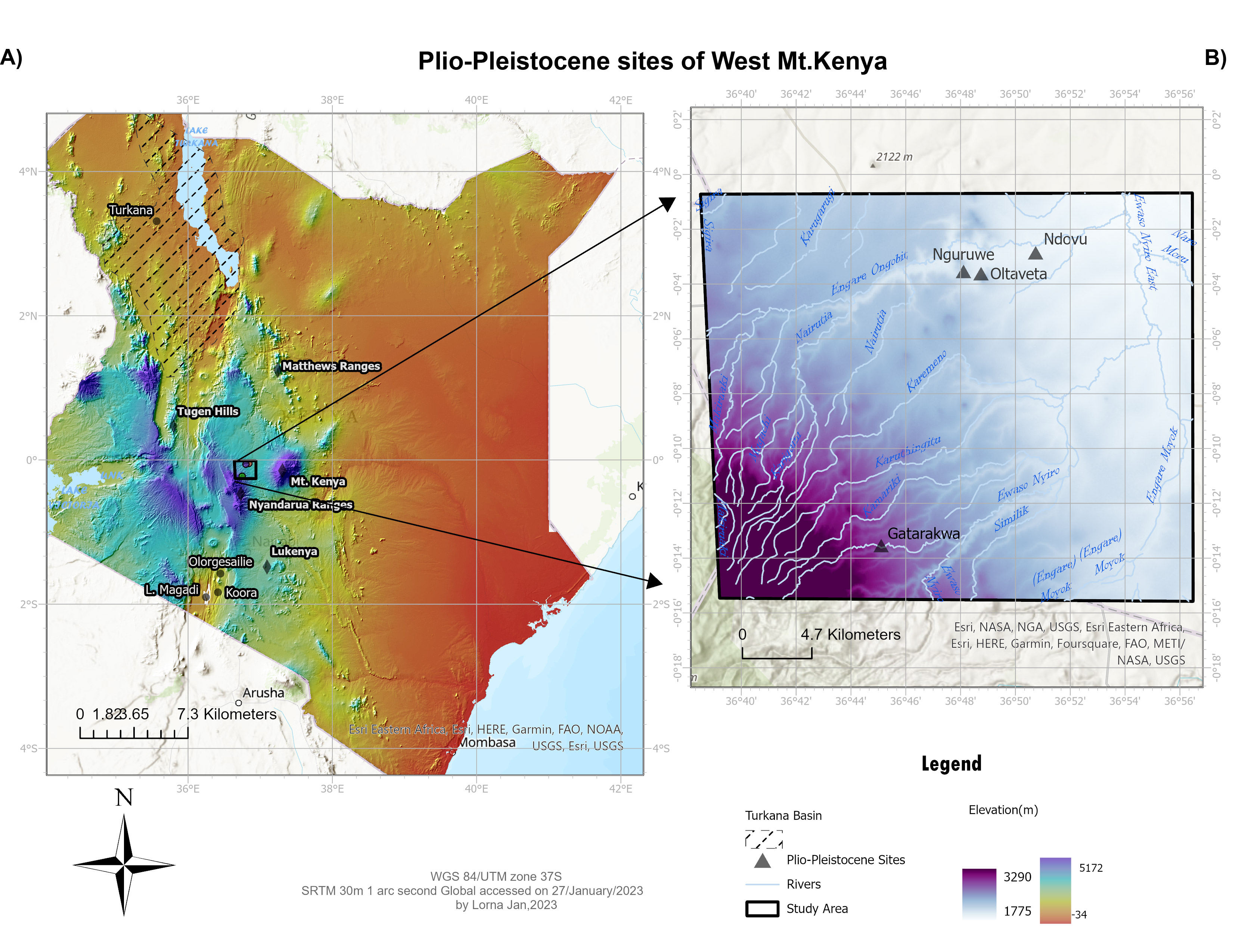
East Africa is renowned for its rich fossil and artefact record, especially on human evolutionary history, technological innovations, and advancement. Most East African prehistoric sites are found within, or in close association with, the East African Rift System (EARS). Here, we report on new fossil locality from the CHK that are unassociated with the EARS (Kirera et al. 2001; Malit et al. 2003). It is located at high elevation and surrounded by Mt. Kenya, the Aberdare Range, and the Mathews Range (Fig. 1). The mountain ranges influence local precipitation which differs from the country’s bimodal rainfall pattern (Nicholson 2017).
The CHK sites were discovered in 1999. Key fossil findings include remains of extinct megafauna; a fossilized tooth (lower p4) of a pig (Nyanzachoerus sp.); two kinds of extinct elephant (Deinotherium sp. and Anancus sp.); giant, long-horned wild cattle (Palerovis sp.); Carnivora; wild horses; small antelopes; and archaic Homo sapiens (Kirera et al. 2001; Malit et al. 2003). In addition, lithic technologies ranging from Early- to Late- Stone Age were also discovered. Based on the fossil evidence and the toolkits present, sites at the CHK span the last 5 Myr and may provide important information about a major extinction of African megafauna recorded at ca. 4.6 Myr BP (Faith et al. 2018).
To date, around 15 fossil-bearing sites have been identified at the CHK, providing a record that spans the earliest Pliocene through to the Holocene. Based on this fossil evidence and the transitional lithic technologies present, we conclude that the history of occupation at the sites is long, suggesting that CHK has been continuously resourceful and accessible to both fauna and humans for the Plio-Pleistocene (Kirera et al. 2001; Waweru, personal communication). Hence, CHK was occupied through periods of extreme climate variability recorded during the Pleistocene (Kaboth-Bahr et al. 2021). These attributes make CHK unique compared to other sites associated with the EARS, which more often represent intermittent occupation.
During the Plio-Pleistocene, as well as today, the CHK ecosystem was characterized by a habitat mosaic. The main goal of studying the past vegetation at the CHK is to understand the role played by the high-elevation sites of the CHK in the evolution of hominins and associated fauna and flora in East Africa during the Plio-Pleistocene. Specifically, this paper addresses the question of environmental dynamics attributed to variable wet–dry climates using palynological data.
Geological, paleontological and archaeological settings
CHK sites are located at high elevation associated with complex geological activities of the uplift and volcanism linked to the formation of Mt. Kenya to the east and the Aberdare Range to the west (Fig. 1). Radiometric dating (40Ar/39Ar) of volcanic tuffs from the CHK yielded ages of ca. 3 Myr BP, while biostratigraphic correlation indicates an age of ca. 5 Myr BP. Faunal fossils at the Nguruwe site include extinct pig Nyanzachoerus cf. kanamensis, which has been recorded in Pliocene sediments in the Turkana Basin and Tugen Hills (Bishop 2010; Hill et al. 1986). Remains of the extinct bovids Megalotragus spp. and Damaliscus spp. are also found at Ngobit and Oltaveta sites, and were previously recorded in Pleistocene deposits at the Lukenya sites (Faith et al. 2012; Potts and Deino 1995). Ngobit sites also preserve lithic technologies from Early-to Late Stone Age. One of the sediment layers at Ngobit was radiometrically dated, yielding ages between 614 kyr BP and 500 kyr BP, and containing hominin skull fragments, as well as Acheulean and transitional Acheulean to Middle Stone Age tools (Waweru, personal communication).
|
|
|
Figure 1: (A) Map of Kenya showing the Central Highland Kenya (CHK) locality, mountain ranges, and other comparable sites associated with the East Africa Rift System (Turkana Basin, Tugen Hills, Lukenya). (B) Map showing location of different CHK sites. |
Site significance
Highlands, among other zones such as coastal forests, lake margins and riparian habitats, are identified as potential tropical Quaternary refugia (Basell 2008; Joordens et al. 2019; Lahr and Foley 2016). Paleontological and archaeological evidence suggest that CHK sites were most likely refugia sites, being resourceful and habitable especially in events of extreme aridity in the East African region (Faith et al. 2012; Maslin et al. 2014). As the tropical African climate periodically shifted between humid and dry conditions, the CHK provided favorable and preferred habitats through orographic lift and topographic attenuation of orbitally forced climatic changes (Maslin et al. 2014). We hypothesize that the CHK biomes were resilient to remote climatic forces and, therefore, continuously habitable from the Pliocene to the Holocene period.
Vegetation data
This paper presents preliminary vegetation data inferred from phytolith analyses at several CHK sites. Phytoliths are silica plant cells’ casts formed in plants during growth. Upon plant decomposition, the cell casts are deposited in the soils and stay preserved for long periods of time. Their unique morphological features enable identification and classification of plant families (sedges, palms, and grasses) and taxa (woody, grasses, and herbaceous) (Piperno 2006). Phytoliths are reliable proxies to distinguish between C3 and C4 grasses, offering critical information on past temperature and precipitation (Fredlund and Tieszen 1997). C3 grasses are adapted to cool climates in tropical highlands, while in temperate regions they are even found at low elevations. C4 grasses constitute the highest proportion of low-elevation vegetation cover, with C4 tall grasses thriving best in warm and humid climates, while C4 short grasses are adapted to hot and dry climates (Piperno 2006). We processed and analyzed 20 samples collected from Pliocene and Pleistocene CHK sites to investigate if vegetation cover and structure differed between the two geological periods. We compared the vegetation data with the available faunal data to examine if both datasets reflect similar paleoenvironmental conditions at CHK
Significance of the vegetation data
Figure 2a shows the relative proportion of plants identified to family level (grasses, palms, and sedges) and taxa level (herbs, grasses, and woody taxa) using fossil phytolith, while Figure 2b are examples of the morphotypes identified. Phytolith data from the fossil samples reflect mixed wooded grasslands consisting of C3 and C4 grasses at CHK during the Pliocene and Pleistocene. However, the proportion of woody versus grass taxa varies across samples within the same age range. Some samples have a significant proportion of sedge and palm phytoliths, indicating that wetland habitats were dominant at CHK. Phytolith data from the modern soil samples (Fig. 2a) indicate mixed wooded grasslands, but with proportions varying across samples. This suggests vegetation cover has been stable and consistent on the CHK landscape since the Pliocene period. CHK sites, therefore, have been a suitable habitat for a variety of faunal species, including hominins.
 |
|
Figure 2: (A) Diagram showing relative morphotypes abundance and identified plant families using fossil phytoliths analyzed from CHK sites. Vertical axis shows the geological period brackets of the sites and the samples analyzed. The horizontal axis shows relative morphotypes abundance and the identified plants/taxa in different samples. (B) Microphotographs of some of the phytoliths identified (from top to bottom): bilobate from grass, globular ornate from woody taxa, and achene from sedges. |
While paleontological data at CHK sites indicates strong evidence of a megafaunal extinction at the Pliocene-Pleistocene boundary, stability of vegetation data shown here indicates that it is unlikely that changes in vegetation contributed to that extinction. Instead, the stable composition of the paleovegetation likely contributed to act as refugia hotspots which supported species survival long before the extinction. Ongoing research at the CHK is trying to refute this hypothesis. Paleoenvironmental information in the East African highland sites is currently lacking, or scarce. Therefore, more research is necessary to provide crucial information on faunal evolution history in this region.
affiliations
1Department of Archaeology, Max Planck Institute of Geoanthropology, Jena, Germany
2Department of Earth Sciences, National Museums of Kenya, Nairobi, Kenya
3Human Origins Program, Smithsonian National Museum of Natural History, Washington, USA
4Department of Anatomy, College of Graduate Studies, Midwestern University, Glendale, USA
5Department of Biomedical Sciences, Mercer University, Macon, USA
6Council on African Studies at the MacMillan Center for International and Area Studies, Yale University, USA
7Department of Anthropology, SUNY, Potsdam, USA
8Department of Geosciences and the Environment, Technical University of Kenya, Nairobi, Kenya
9Unaffiliated geologist, Nairobi, Kenya
10Department of Geosciences, Georgia State University, Atlanta, USA
11Unaffiliated naturalist, Nairobi, Kenya
contact
Rahab N. Kinyanjui: kinyanjui@shh.mpg.de
references
Basell LS (2008) Quat Sci Rev 27: 2484-2498
Bishop LC (2010) In: Lars W (Ed), Cenozoic Mammals of Africa. California Scholarship Online, 821-842
Faith JT et al. (2012) Palaeogeogr Palaeoclim Palaeoecol 361-362: 84-93
Faith JT et al. (2018) Science 362: 938-941
Fredlund GG, Tieszen L (1997) Palaeogeogr Palaeoclim Palaeoecol 136: 199-211
Joordens J et al. (2019) J Hum Evol 131: 176-202
Kaboth-Bahr S et al. (2021) Proc Natl Acad Sci 118(23): e2018277118
Kirera FM et al. (2001) J Hum Evol 40(3): A11-A12
Malit NR et al. (2003) Am J Phys Anthropol 120: 145
Maslin M et al. (2014) Quat Sci Rev 101: 1-17
We studied palynological and archaeological proxies to reconstruct the environmental and human–ecological history of the Okomu National Park in Nigeria. We observed distinct environmental phases characterized by the interplay between mangroves, freshwater forests and human influence.
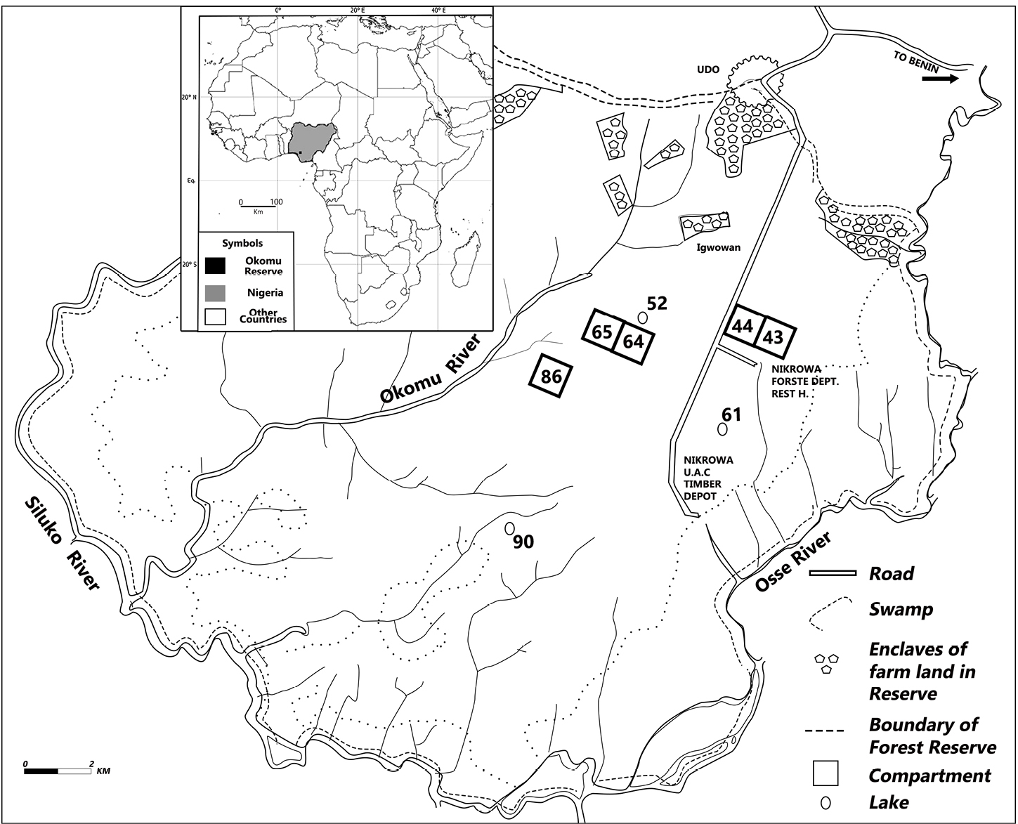
Here, we show the results of some environmental archaeological investigations carried out in the rainforests of Okomu National Park (ONP), located 60 km northwest of Benin City in southern Nigeria. The ONP is a small area within the Okomu Forest Reserve (OFR); a forest block of about 1238 km2 (White and Oates 1999; Fig. 1), and remains a fully protected park. Nowadays, the vegetation consists of Guinea–Congo lowland rainforest, including areas of mangrove swamp forest, freshwater swamp forest, high forest, secondary forest, and open scrub. Some of the most common trees are Bombax buonopozense, Celtis zenkeri, Triplochiton scleroxylon, Antiaris africana, Pycnanthus angolensis and Alstonia congensis.
 |
|
Figure 1: Map of Okomu National Park near Benin, southern Nigeria. |
Previous studies in the area (Jones 1955, 1956; White and Oates 1999) reported the occurrence of charcoal and pottery based on dugouts from several pits in compartments 43, 44, 65, and 86 in the park. According to the report, the pits showed three distinct layers. The deepest layer (100–50 cm) had only charcoal, the second layer (50–20 cm) had charcoal, charred palm kernels and pottery. The third and shallowest layer (20–0 cm) lacked any cultural, charred or microfossil remains, which was interpreted as an abandonment period. Based on these results, Jones (1956) and White and Oates (1999) stated that the landscape of the ONP was not always a rainforest, but must have been occupied by farmlands and villages in the past. Furthermore, charcoal samples collected from compartments 86 and 65 at depths of 20 cm and 28–20 cm yielded radiocarbon dates of 760 ±50 yr BP and 700 ±60 yr BP, respectively (White and Oates 1999). This indicated that ONP was abandoned about 760–700 years ago (12th–14th centuries CE) (White and Oates 1999). The question that arises is why these settlers left the area. The abandonment event has been attributed to at least three possible factors, namely (1) climate change; (2) epidemic; and/or (3) the war between the kingdom of Benin and Udo, a city-state on the northernmost part of the ONP (Jones 1956), which occurred during the late 13th century. However, these hypotheses remain untested. Therefore, this study was designed to reconstruct the environmental and human-occupation history of the ONP using palynological and archaeological data.
Palynological and archaeological investigations
For the palynological component, we collected sediment cores from Lakes 90, 61 and 52 in the ONP and analyzed the pollen, spores, diatoms and charcoal to reconstruct the park’s environmental history. A one-meter square test pit (60 cm in depth) archaeological excavation was also conducted on compartment 65 to understand the occurrence and distribution of the cultural material in that part of the ONP.
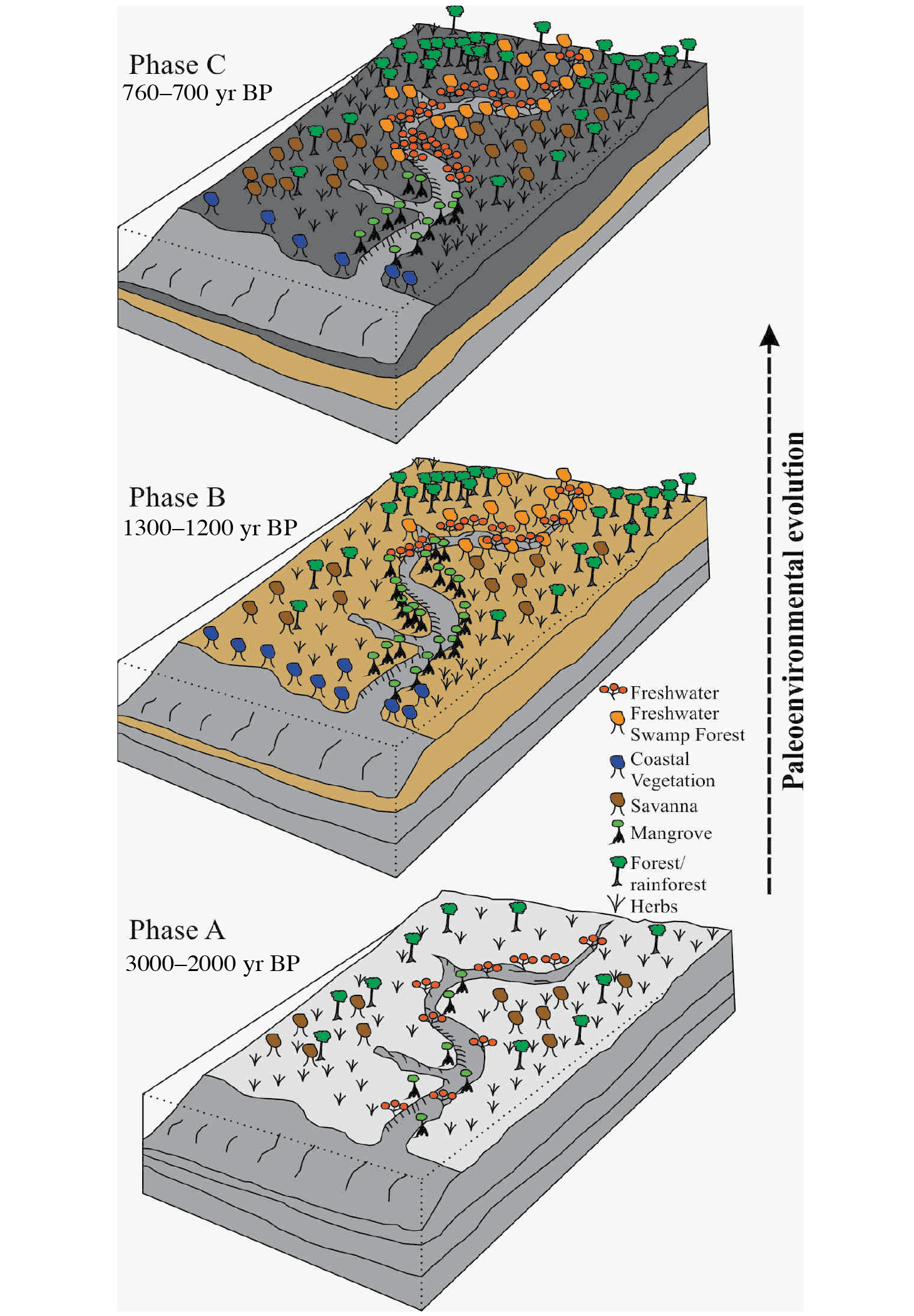
The analyses of samples for palynological content yielded pollen grains, pteridophyte and fungal spores, algae and the lacustrine diatom Aulacoseira sp., which were used to distinguish three environmental phases; A, B and C (Fig. 2). For ease of interpretation, the pollen and spores were grouped into six ecological classes, namely mangrove swamp forest, coastal vegetation, freshwater swamp forest, freshwater, lowland rainforest and savanna. The earliest phase (A), was identified only in Lake 90 and was characterized by the presence of mangrove swamp forest, some secondary forest and freshwater taxa. By comparing this pollen assemblage with data from other sites in southern Nigeria and West Africa (Sowunmi 2004; Tossou et al. 2008), we interpreted that Phase A must have occurred between 3000 yr BP and 2000 yr BP. The intermediate phase (B), characterized by mangroves, freshwater and swamp forests taxa, and present in all the studied lakes, was interpreted as the first development of the rainforests. This development likely occurred between 1300 yr BP and 1200 yr BP (Orijemie 2020). We recovered pollen remains typical of anthropogenic disturbance of natural vegetation (Asteraceae), and economic plants (Vernonia amygdalina, Zanthozylum cf. zanthoxyloides, Spondias mombin and Parkia biglobosa) at a depth of 0.9–0.8 m in sediments of Lake 90 which corresponded to the terminal period of Phase B. These findings were interpreted as indicative of the presence of humans in Okomu. During the third phase (C), which was identified in all the lakes, there is a decline of the mangroves and secondary forest plants (Elaeis guineensis and Alchornea sp.), while rainforest taxa showed an increase. This vegetation change represents a marked decrease in human activities, and, hence, a regeneration of the rainforest at ca. 760–700 yrs BP.
 |
|
Figure 2: The reconstructed environmental changes in the Okomu National Park, Nigeria. |
The excavations in the test pit revealed three distinct stratigraphic layers. The deepest layer (60–40 cm) was devoid of artefacts, although we found a relatively high amount of charcoal particles. The occurrence of charcoal could either be of anthropogenic or natural origin. The remains of potsherds, charred palm kernels (Elaeis guineensis) and the cranial bone of catfish (Clarias sp.) in the second layer (40–20 cm) suggest the presence of settlers who carried out some agricultural and fishing activities. The third stratigraphic layer (20–0 cm) did not have any palynological or archaeological remains. This last sediment horizon probably represents the period when the Okomu area was abandoned, allowing the forest to regenerate.
Human occupation of Okomu National Park
The archaeological data suggest the presence of humans in the ONP at least between the 12th and 14th centuries CE, which agrees with previous findings by Jones (1956), and White and Oates (1999) about human occupation in this area. Palynological evidence from the region also supports this chronology, as sediment cores from Okomu Lakes 90, 61 and 52 showed human presence at depth 90–80 cm of Lake 90, 50–0 cm of Lake 61, and 45–0 cm of Lake 52 sediment cores. This is the first time that pollen indicators of human disturbance and economic plants are documented in the ONP. Furthermore, the distribution of archaeological materials across a large area, stretching over 15 km, also provides unique evidence that the ONP was a "densely populated and intensively cultivated landscape" (White and Oates 1999) before the final abandonment during, or shortly after, the 14th century CE.
The Okomu abandonment event
As indicated earlier, the abandonment event has been attributed to at least three possible factors, namely (1) climate change; (2) epidemic; and/or (3) the war between Benin and Udo. There are reports of the occurrence of a dry climate in West Africa during the 14th–16th centuries CE (Lézine et al. 2019; Logan and Stahl 2017) that had significant demographic impact in the region. However, this dry phase has not been identified in palynological records from the Okomu sediment cores, which showed an increase in rainforest taxa during that time. The outbreak of an epidemic has been documented in the location of Iguowan, within the ONP, but 200–150 yrs ago (Jones 1956), after the abandonment of the Okomu region. Udo rivalled Benin for centuries, but it was destroyed twice by the forces of the ruler of Benin (called Oba); first by Oba Oguola at around 1285 CE (Egharevba 1960), and second by Oba Esigie at ca. 1520 CE (Jones 1956). The warfare in ca. 1285 CE would be contemporaneous with the period when the Okomu area was abandoned, and when the rainforest regenerated and became floristically diverse, as noted in the pollen record.
This work investigated the environmental and human–environment history of the Okomu National Park. We showed, using a combination of palynological evidence and archaeological data from diverse types of sediment records in the Okomu forest, that there were landscape changes due to a combination of natural and anthropogenic factors. More importantly, we observed clear evidence that the area was inhabited until the 14th century CE when it was abandoned, most likely because of the warfare between the kingdoms of Benin and Udo.
Acknowledgements
Appreciations go to Alhaji Ibrahim Musa Goni, the Conservator General of the Nigeria National Park Service, who provided approval for this research. We gratefully acknowledge the Conservator of Parks of the Okomu National Park, Mr. Adeniyi Tesleem Kareem, and members of staff who assisted our team during our visit to Okomu in 2019. Thanks are due to Prof. M. Adebisi Sowunmi who provided the sediment core samples from Lake 90.
affiliations
1Department of Archaeology and Anthropology, University of Ibadan, Nigeria2Department of Earth and Environmental Sciences, Columbia University, New York, USA
contact
Emuobosa A. Orijemie: orijemie17@gmail.com
references
Egharevba JU (1960) A Short History of Benin. Ibadan University Press, 101 pp
Jones EW (1955) J Ecol 43: 564-594
Jones EW (1956) J Ecol 44: 83-117
Lézine A-M et al. (2019) Rev Palaeobot Palynol 27(1): 1-7
Logan AL, Stahl AB (2017) J Archaeol Method Theory 24(4): 1356-1399
Human-made water bodies, called talavs, are common features of arid and semiarid regions of South Asia. Multi-disciplinary research into these talavs demonstrates untapped potential to investigate the long-term response of coupled human–environment systems to climate fluctuations in these regions.
Rain-fed watersheds in arid and semiarid regions of South Asia – home to millions, and host to major agricultural and urban centers – are some of the most vulnerable climate hotspots (regions that experience pronounced and well-documented impacts of anthropogenic climate change; Khan and Cundill 2019). Anthropogenic climate change, combined with rapid changes in land-use patterns (e.g. agriculture and urbanization), has degraded natural resources in these watersheds resulting in increased economic stress, social instability and escalating conflict (ASSAR 2018). In order to formulate better solutions to manage water resources in these hotspots, there is mounting demand from both scientists and policymakers for an improved understanding of the relationship between human communities and natural resources, especially under different climate scenarios.
The famous American poet Robert Penn Warren observed, "History cannot give us a program for the future, but it can give us a fuller understanding of ourselves, and of our common humanity, so that we can better face the future." Watersheds in arid and semiarid regions of South Asia, which have witnessed human settlement for millennia, represent a tight coupling of human–environment interactions that have evolved over the longue durée* in response to a complex interplay of climatological, environmental, cultural and historical events (Ray et al. 2021). However, studies documenting how human societies have responded to water bodies in these climatologically threatened watersheds over the longue durée are lacking. Here we explore a unique, but ubiquitous, type of surface water body – human-made surface water bodies called talavs – to understand the evolution of human responses to water resources in semiarid climate hotspots of western India during documented periods of climate fluctuations.
*Longue durée means "long duration" and is used to describe the effects of events that occur slowly enough to be imperceptible, and allows studies of human history to accommodate climatology, demography, geology, and oceanography (Braudel 2009).
What are talavs? Why and how do we study them?
In arid and semiarid regions of South Asia, a unique type of surface water body, created by damming tributaries and distributaries of seasonal rain-fed river channels, are ubiquitous. The dammed river channels, colloquially known as talavs, are mentioned in archaeological studies (Shanmugasundaram et al. 2017), historical texts and in contemporary policy literature (ASSAR 2018) in relation to water access for the purposes of sustenance, agriculture, communication and urbanization. Talavs typically have an area of ~2–5 km2 and catchment areas ~30–100 km2. Owing to their small size and continued presence over the longue durée, talavs can provide much-needed insights into the nature and causes of evolution of catchment level human–environment interactions under different climate scenarios that are important for policy and planning.
To capture human–environment interactions spanning the lifetime of these talavs, we combine a natural sciences approach with a social sciences perspective. The natural sciences approach involves understanding the state of the water bodies today (e.g. by using remote sensing, geophysical surveys, and biogeochemical analyses) and in the past (e.g. by studying similar downcore properties in sediment cores extracted from lake bottoms). The social lens, on the other hand, involves understanding the human use of these water bodies in the past (e.g. by extracting information related to the talavs from archived administrative colonial texts) and in contemporary times (e.g. by conducting in-depth interviews with stakeholders). We call this novel, mixed method of studying water bodies "the four-pronged approach".
Human–environment interactions in semiarid west Indian watersheds
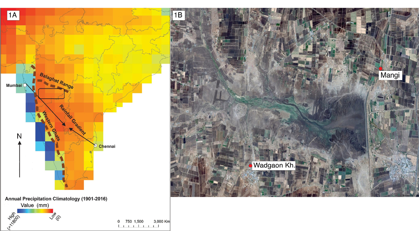
Semiarid regions of western India that overlie the Deccan Traps, and lie in the rain shadow of the Western Ghats (Sahyadri mountain range) running parallel to the western coast of India, is a well-known climate hotspot (ASSAR 2018, Fig. 1a). Talavs are ubiquitous in this region (Fig. 1b). We apply our novel "four-pronged approach" to investigate talavs in several catchment areas of our study area, the Bhima watershed (outlined in Fig. 1a). We list some of our observations below.
 |
|
Figure 1: (A) Study area outlined by the box. (B) Aerial (Google Earth) image of a dammed river in the study area that serves as a human-made talav. |
(a) Combining remote sensing, geophysical surveys and downcore analyses (grain size, X-ray fluorescence and radiometric dating), we found that talavs serve as sedimentary archives recording erosional patterns in the catchment. The erosional patterns are affected by the local environmental (e.g. vegetation) and geological (e.g. slope) factors within the catchment, and the type of structure (e.g. age, height, composition, rate of maintenance of the dams). However, we find that it is the catchment-level manifestation of the large-scale Indian monsoon system that has the strongest impact on the erosional patterns preserved in the sediments of the talavs. Furthermore, we found that drier catchments in the Bhima watershed are at elevated risk of floods caused by anomalous heavy rainfall events in these catchments. Floods cause loss of top soil that is detrimental to farmers, who are the main stakeholders in the area.
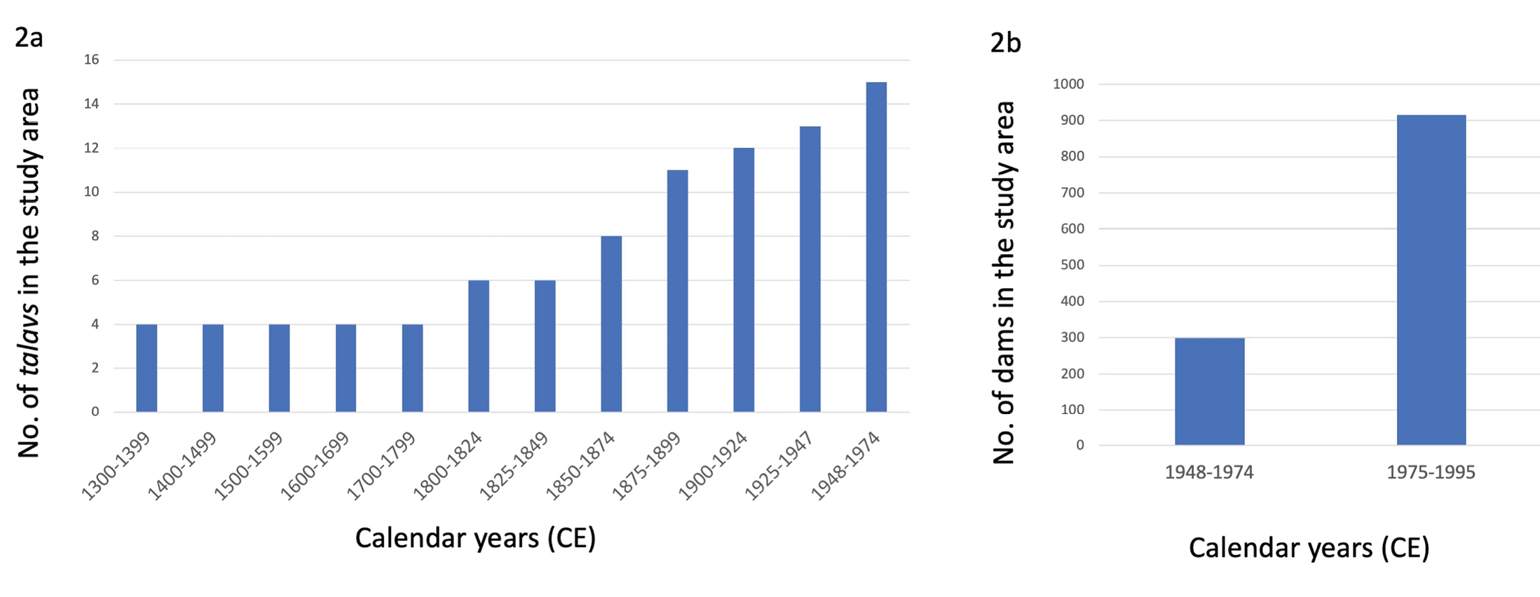
(b) Analysis of information extracted from colonial administrative texts demonstrates that the talavs were first built in this region by the Mughals (~1500 CE) to provide water to local populations during dry spells. Later, the British colonialists, taking advantage of the fertile soil, developed this region intensively during the 18th–20th centuries as a cash crop agricultural center (first cotton, and then sugarcane). They did so by commissioning talavs (Fig. 2a) in response to famines (extreme food shortages associated with low rainfall; Ray et al. 2021) to serve two purposes, namely water conservation for agricultural purposes and to provide non-farm (alternate) sources of employment for local populations during famine years (Ray et al. 2021). After India gained independence in 1947, the government of India undertook a massive construction effort to build large (>15 m high) and small (<10 m high) dams to further increase water-intensive cash crop production (sugarcane) and generate hydroelectricity (Fig. 2b). The construction of talavs was key to preventing food shortages caused by rainfall variability in these semiarid regions and, eventually, turning the region into a major urban center and port.
(c) However, in-depth interviews with stakeholders conducted recently, especially with farmers, revealed that the presence of talavs has changed the nature of climate risks upstream and downstream of these water bodies. Farmers in the upstream region are more vulnerable to rainfall fluctuations than farmers in the downstream region, even though they are only 5 km apart. Downstream farmers continue to grow water-intensive crops like sugarcane and fruits (grapes, bananas), while upstream agriculture comprises less water-thirsty crops, such as millets. This differential access to water has resulted in unequal wealth distribution in the catchment area. In fact, newspaper reports suggest that in recent decades, hoarding of water in these talavs by powerful farmers may have escalated conflict and exacerbated existing inequalities, as demand for water has increased with growing reliance on water-intensive cash crops (Fig. 2b).
 |
|
Figure 2: The proliferation of talavs in the study area. (A) Historical (1300–1974) proliferation of talavs in the study area. Source: Maharashtra State Gazetteers, India, gazetteers.maharashtra.gov.in. (B) Increase in the number of dams during the second half of the 20th century (1948–1995), most of which were constructed in the same way as the historical talavs. Source: Govt. of Maharashtra, India, maharashtra.gov.in. |
Implications for policy and climate research
Talavs provide catchment-level information on parameters such as the rate of loss of top soil, flood risk, etc. that are critical for informing policy and drawing management plans. Climate information preserved in sediments collected from the talavs also helps ground truthing downscaled climate models, critical for local climate prediction purposes. But most importantly, talavs provide invaluable insights into how human communities, based on their socioeconomic and cultural realities, respond to climatic changes. These insights address relevant climate–society questions such as human migration and conflict. Scientific exploration of small water bodies (Jacob et al. 2020; Penny et al. 2007) require multi-disciplinary and creative approaches, which can be logistically challenging and cost prohibitive to undertake. However, considering the value these explorations provide in understanding climate–society linkages, more studies should be undertaken. Finally, engaging with local populations, who use such resources to sustain their communities in a reciprocal manner, offers an opportunity for a more community-engaged approach to paleoscience.
Acknowledgements
We thank the Maharashtra Forest and Irrigation Department, the Unique Group and Amey Datye (IITM-Pune) for assisting in the fieldwork.
affiliations
1CIRES and Center for Asian Studies, University of Colorado, Boulder, USA2Indian Institute for Human Settlements (IIHS), Bengaluru, India
3Indraprastha Institute of Information Technology (IIIT), New Delhi, India
4Ohio State University, Newark, USA
5Indian Institute of Science Education and Research (IISER), Pune, India
6Indian Institute of Science Education and Research (IISER), Mohali, India
7State University of New York Maritime College, USA
8Indian Institute of Tropical Meteorology, Ministry of Earth Sciences (MoES-IITM), Pune, India
9Pune University, India
10Deccan College-Deemed University, Pune, India
11University of British Columbia, Vancouver, Canada
12Indian Institute of Technology (IIT), Kharagpur, India
contact
A. Bhattacharya: atreyee.bhattacharya@colorado.edu
references
ASSAR (2018) Adaptation at Scale in Semi-Arid Region. Report on Maharashtra, accessed on 5 April 2023, www.assar.uct.ac.za/assars-work-maharashtra
Braudel F (2009) Review (Fernand Braudel Center) 32(2): 171-203
Jacob R et al. (2020) Anthropocene 68(3): 100238
Khan AS, Cundill G (2019) Ambio 48: 639-648
Penny D et al. (2007) Nucl Instrum Methods Phys Res B 259: 388-394
How climate change influenced societies in the past is a key issue facing ongoing and future climate change. Past human society–environment relationships in northern Chile provide evidence of different ways to cope with climate change in extreme environments.
Either naturally or anthropogenically driven, climate changes could lead to large environmental changes and, hence, affect socio–economic activities at different temporal scales. Nowadays, as in the past, the world is facing these effects as climate changes occur, impacting human societies in different ways and forcing them to adapt, resist, or migrate.
Currently, in Chile, this situation is critical because of the scarcity of water following the decreasing precipitation trend. Its effects are quite clear, including the drying of high Andean wetlands and lakes, the lowest historical stands of water reserves, loss of vegetation cover, and the abandonment of productive land. However, northern Chile has experienced a series of climatic changes at millennial to centennial timescales. How did human societies cope with these past changes? Did some of them make adjustments in response to climatic changes? If yes, were those responses synchronous with the climatic changes? These and other questions can be answered through interdisciplinary research using geosciences and archaeology across sites in northern Chile.
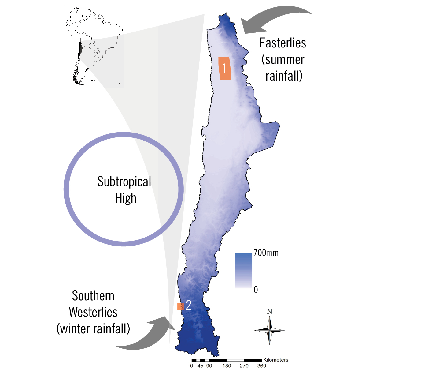
In this article, we focus on two main regions (Fig. 1): Pampa del Tamarugal, in the center of the Atacama Desert (21°S), which reveals a fascinating Late Holocene development of agricultural societies in the driest desert of the globe; and Los Vilos, located in the semiarid coast of subtropical Chile (32°S), which was a region inhabited by hunter-gatherers specialized in exploiting marine resources throughout the Holocene.
Climatic setting
The Pampa del Tamarugal records near zero precipitation throughout the year, and surface runoff is only associated with extreme rainfall events in the highlands. Precipitation sourced from the east and associated with the South American summer monsoon falls in the Andean highlands (Altiplano) (Fig. 1) and infiltrates the land, becoming subterranean discharge. Once in the lowlands, the subterranean water table reaches the surface.
In contrast, on the semiarid coast of Chile (32°S), precipitation is around 200 mm/yr and represents a marked seasonality, with winter-centered rainfall controlled by the Southern Hemisphere Westerlies (SHW) (Fig. 1). River discharge shows a fluvio-nival pattern with increasing amounts in winter and spring.
 |
|
Figure 1: Map of the study area showing annual precipitation and the main climatic features of northern Chile. The orange rectangles show the study sites of Pampa del Tamarugal (1) and Los Vilos (2). |
Farmers in the arid Atacama Desert
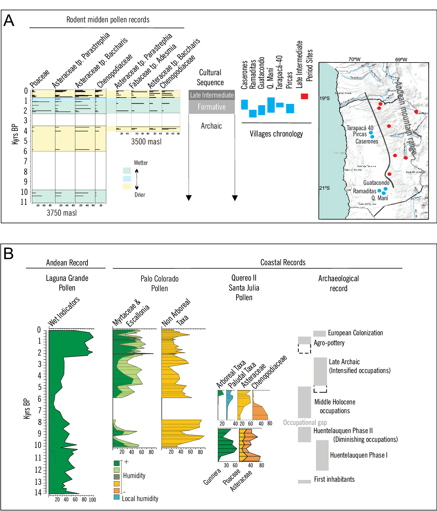
The archaeological record of Pampa del Tamarugal shows abundant evidence of hunter-gatherer societies since 11 kyr BP (Fig. 2a). These groups settled along active springs, canyons, and wetlands in the center of the desert until 9.5 kyr BP, when conditions became so dry that only a few sites were occupied during the Mid-Holocene (Santoro et al. 2017). It was not until the Late Holocene (after 3 kyr BP) that these areas were again occupied, though showing quite different characteristics. A marked transitional period from exclusively hunter-gatherer societies to the development of agriculture, a sedentary lifestyle, and a high degree of social complexity occurred in the Pampa del Tamarugal at around ~2.5–1 kyr BP (the Formative Period; Fig. 2a). A vast array of diverse archaeological evidence recorded over hundreds of kilometers reveals the development of a network of multiscale settlements. These include villages with monumental public areas and intensive and extensive agriculture as shown not just by the cultivation plots, but by sophisticated technologies to manage surface water (Adán et al. 2013; Urbina et al. 2018; Fig. 2a). The development of such complex societies in the core of the desert (2000–1000 masl) cannot be explained unless this happened under completely different climatic conditions than those of today.
Pollen records from rodent middens collected at 3500 and 3750 masl at 21°S were used to reconstruct past environmental condition changes (Fig. 2a; Maldonado and Uribe 2015). The rodent midden pollen record at 3500 masl reflect drier conditions than present at around 3.7 kyr BP, and after 700 yr BP, while wetter conditions occurred between 2 kyr BP and 700 yr BP. On the other hand, the rodent midden pollen record at 3750 masl shows wetter than present conditions at around 10 kyr BP and 2.2–1 kyr BP, drier than present conditions at around 3.5 kyr BP and after 700 yr BP, and a transitional wet-to-dry phase between 1 kyr BP and 700 yr BP.
As for the archaeological record, central villages of the Formative Period started at around 2.3 kyr BP and were occupied until at least 1 kyr BP. By that time, villages of the Late Intermediate Period started growing in higher altitude canyons to the north, following the precipitation gradient. Thus, when integrating the environmental and archaeological evidence of Tarapacá, where water is extremely scarce and critical for survival, there is synchronicity between the occurrence of wetter-than-present conditions and the intensification of settlement and cultivation plots, accompanied by more social complexity during the Formative Period (Uribe et al. 2020). Besides, the development of villages at higher and more northern canyons occurred when conditions became transitional towards drier than present, during the Late Intermediate Period.
Coastal hunter-gatherers of semiarid Chile
In semiarid coastal Chile, the environment–human relationships are rather different to those in the Atacama Desert, and the key environmental archives for tracing past environmental and climate changes are sedimentary records in coastal swamp forests. Coastal swamps form diverse and densely vegetated hygrophilous small forests in a matrix of semidesert shrublands, and grow in areas where the water-table level reaches the surface. The coastal water-table level is recharged by precipitation falling above 2000 masl that infiltrates and moves underground.
 |
|
Figure 2: Comparison of paleoclimatic records and archaeological sequences in (A) the Pampa del Tamarugal (blue dots and rectangles correspond to Formative Period sites and red to Late Intermediate Period sites); and (B) Los Vilos areas. |
The swamp-forest pollen records show the occurrence of the two most contrasting periods corresponding to the driest interval between ~8–5 kyr BP, and the wettest period starting at 2 kyr BP (Fig. 2b; Maldonado et al. 2010; Maldonado and Villagrán 2006; Méndez et al. 2015). On the other hand, the archaeological record including more than 200 sites (mostly coastal and corresponding to shell middens) reveals an almost continuous presence of humans in the area for the last 13 kyr (Fig. 2b; Méndez and Nuevo-Delaunay 2021).
When integrating the environmental and anthropogenic trends (based on the sum of probabilities of radiocarbon dates, Méndez et al. 2018), both synchronous and asynchronous events are recorded. While people lived along the coast regardless of the environmental conditions, likely due to the permanent supply of marine resources, inland sites show a marked occupation only since 3 kyr BP, when the climate shifted towards wetter conditions, as shown by the pollen records of Laguna Grande (Fig. 2b). The archaeological evidence suggests different mobility and occupation patterns of the coast over time. The initial human presence in the area was coeval with extinct megafauna under slightly wetter conditions than present. The first coastal adaptations at ca. 12 kyr BP reveal an almost permanent presence of settlers, with occasional incursions into the interior, under relatively humid but variable environmental conditions. During the Early Holocene (Huentelauquén Phase II) (Fig. 2), as the environment became drier, the once coastal hunter-gatherers turned their attention to ravine resources, and inland incursions increased. Interestingly, the driest spell of the sequence is associated with a decrease, and almost abandonment of, the coastal settlements between 8.3 and 7.6 kyr BP (Méndez and Nuevo-Delaunay 2021). After this extremely arid phase, settlements were again located along the coast. With the gradual return to wetter conditions, occupation density reached their maximum at 3 kyr BP, either in coastal or inland archaeological records. Finally, with the development of horticulture and pottery at 2 kyr BP (Early Ceramic Period), coastal occupations became less prominent, and groups increasingly occupied the inland under wetter than present conditions, at the expense of the use of coastal landscapes and their resources.
Final words
The case studies of human society–environment relationships in northern Chile show that people coped with past climate change at centennial timescales by either technological developments to manage the water, or by occupying sites where resources were independent of the environmental/climatic scenarios. The occupation of alternative sites (inland) or migration (highlands) occurred under the establishment of extremely wetter or drier conditions, respectively.
affiliations
1Centro de Estudios Avanzados en Zonas Áridas (CEAZA), La Serena, Chile2Centro de Investigación en Ecosistemas de la Patagonia (CIEP), Coyhaique, Chile
3Departamento de Antropología, Universidad de Chile, Santiago, Chile
contact
Antonio Maldonado: antonio.maldonado@ceaza.cl
references
Adán L et al. (2013) Est Atacameños 45: 75-94
Maldonado A et al. (2010) J Quat Sci 25: 985-988
Maldonado A, Villagrán C (2006) Quat Res 66: 246-258
Méndez C et al. (2015) Quat Int 21: 15-26
Santoro CM et al. (2017) J Anthropol Archaeol 46: 28-39
Over the millennia, complex and elaborate cultures have emerged in the Lake Titicaca region. Recent archaeological evidence and new environmental reconstructions spanning the last ~4500 years have enabled us to explore the interactions between cultural developments of past societies and the changing environment.
The history of societies is influenced by interactions between humans and their environment. This is particularly the case for communities of the high tropical Andes, who repeatedly experienced large amplitude changes in climate and the surrounding landscape.
Here we present recent underwater archaeological evidence and paleoenvironmental reconstructions compatible with archaeological timescales. We then focus on identifying and exploring the relation between major environmental changes and cultural innovations in the Lake Titicaca region to decipher potential relationships.
Lake Titicaca sediment: An archive of past climate change and human activities
Lake Titicaca’s sediment record preserves both natural variability and cultural-related signals (Guédron et al. 2021). Multiple studies have reconstructed water-level variability from diverse proxies (e.g. sedimentology, geochemistry, microfossils) and inferred fluctuations in moisture balance at the regional scale (Baker et al. 2001). In general, the temporal resolution of existing paleoenvironmental studies in Lake Titicaca was not high enough to be compared with archaeological studies.
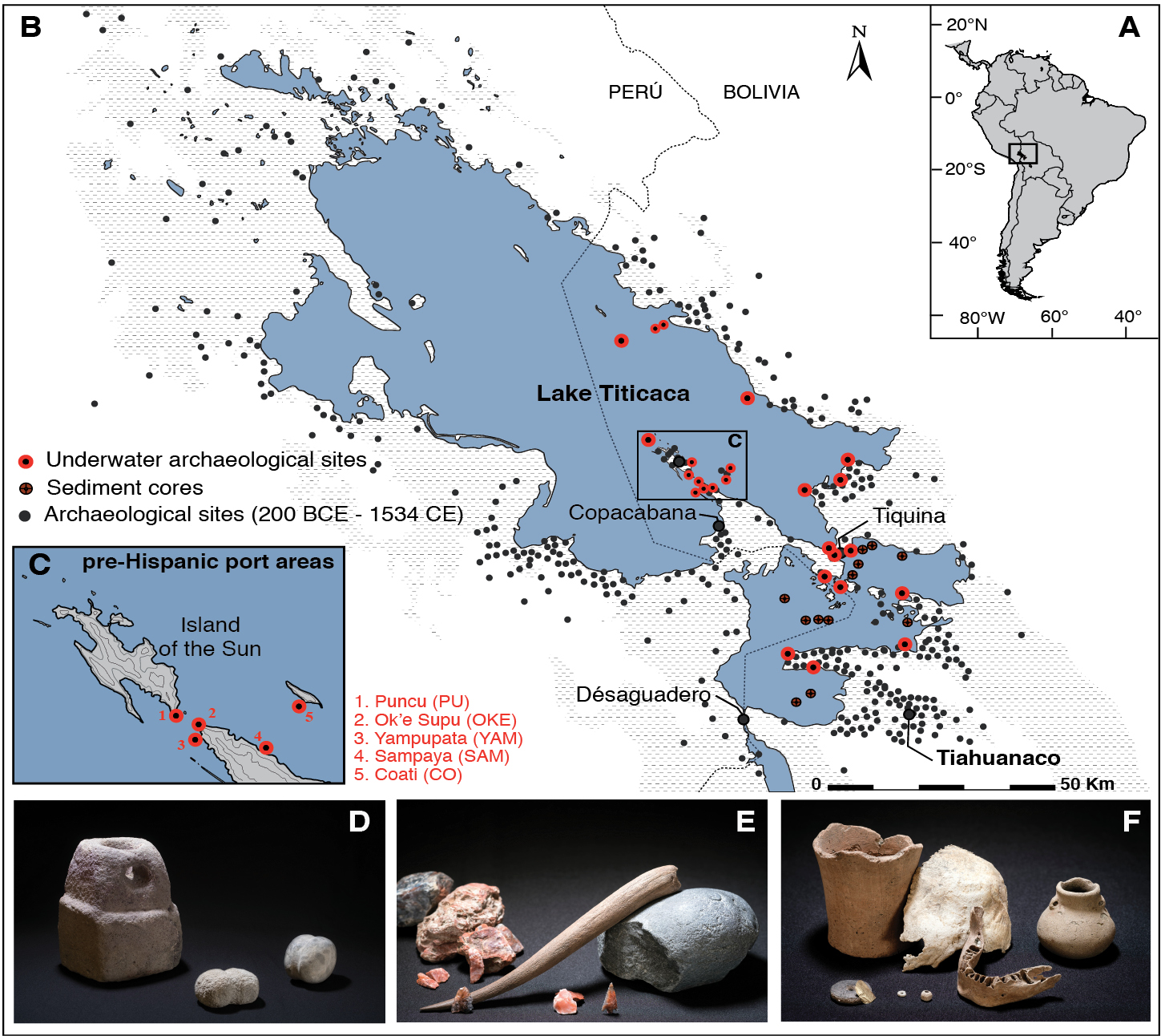
A relatively novel approach in the last decade has been underwater archaeological studies which enabled the refinement of the dating of sediment layers at the archaeological timescale by the analysis of ceramic remains found buried in the sediment. For the first time, underwater archaeological remains and artefacts in Lake Titicaca’s sediment have shed light on the impact of water-level variation on human occupation of the land, and revealed the presence of an unknown, and now flooded, cultural landscape (Delaere 2017; Delaere 2020; Delaere and Guédron 2022) (Fig. 1a–b). Extensive underwater excavations integrating paleoenvironmental approaches have disclosed the presence of pre-Hispanic port areas (Fig. 1c–d), coastal workshop sites dedicated to manufacturing activities (e.g. leather, stone, and wool) (Fig. 1e), and pastoral and human areas that are currently submerged (Fig. 1f). Ritual offerings have also been identified underwater (Delaere et al. 2019; Delaere and Capriles 2020). These cultural artefacts differ, however, from other remains as they are intentional tributes, and not linked to environmental alteration events. Today, more than 25 underwater archaeological sites, mainly submerged coastal settlements, have been explored in Lake Titicaca (Fig. 1b) using underwater geoarchaeological tools (underwater excavations and sediment cores) to better understand the historical interactions between humans (e.g. settlement dynamics), and their changing environment (i.e. transgression and regression of the lake). Remnants of both the anthropogenic and natural ecosystems are perfectly interconnected and preserved in the lake sediments.
 |
|
Figure 1: (A) Location of Lake Titicaca (16°S, 69°W) in the tropical Andes. (B) General map of Lake Titicaca with the location of the archaeological sites surveyed since 1950 (black circles), the underwater archaeological sites surveyed between 2012 and 2022 (red circles), and the sediment cores sampled between 2014 and 2017 (dark orange circles). The coastline is defined as the average modern lake level (3810 masl). The civic-ceremonial center of Tiahuanaco is located in the southern part of the basin. (C) Location of five pre-Hispanic ports discovered between Copacabana Peninsula and the Islands of the Sun and the Moon. (D) Pre-Hispanic navigation artefacts (anchor and ballast stones) discovered underwater at Puncu (PU). (E) Remains of tools belonging to a Tiwanaku stonecutter's workshop discovered underwater in Ok’e Supu (OKE). (F) Remains of a pre-Tiwanaku tomb discovered underwater at Puncu (PU) (Photo credit images D–F: T. Seguin). |
Environmental changes and cultural responses at Lake Titicaca
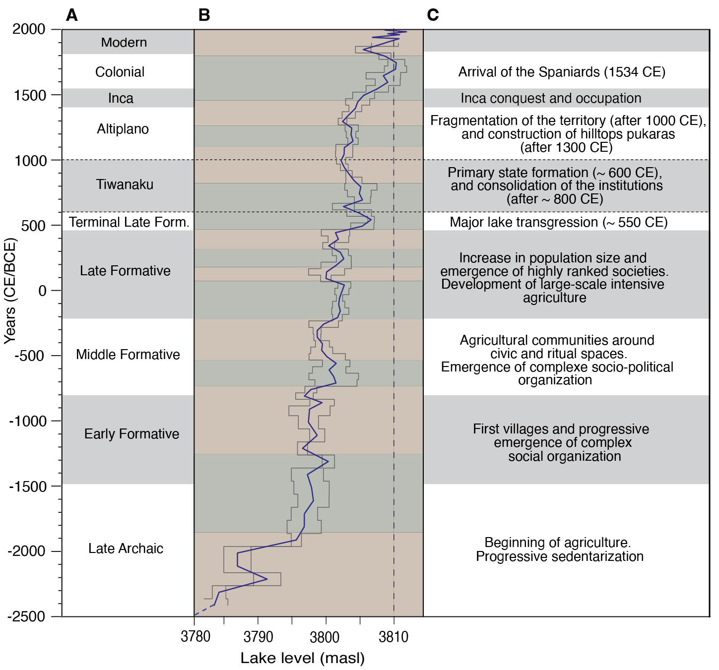
The combination of geological and archaeological methods has enabled the development of a new model of Lake Titicaca’s lake level variations at a resolution compatible with archaeological timescales (Fig. 2) (Guédron et al. 2023). Due to the gentle slopes of the southern Lake Titicaca basin, variation in lake-level of a few meters results in substantial changes in the exposure of surrounding land. Hence, over the past four millennia, human communities have witnessed multiple transgressions and regressions (up to ~5 m) of Lake Titicaca that have submerged, or opened areas for settlement and agriculture (Fig. 2b) (Delaere and Guédron 2022). Yet, ancient native populations in the lake basin undoubtedly had a well-developed knowledge of the local ecosystem and diversified the exploitation of resources in response to climate variability. In the case of agriculture, the succession of dry and wet periods induced long-term cultural responses that illustrate the great resilience of human communities (Bruno et al. 2021).
Increased precipitation led to the gradual rise in lake level from 2400 BCE onward (Fig. 2b). This climatic and environmental shift induced cultural changes and innovations within Lake Titicaca’s human communities. Some of them coincided with significant increases in lake-water level, such as the development of agriculture ca. 2000 BCE (Bruno 2014), farming communities organized around civic-ceremonial centers ca. 800 BCE (Hastorf 2003), or the first "fortified" cities, named pukaras, at the top of the slopes of the drainage basin ca. 1300 CE (Arkush 2008) (Fig. 2).
The emergence or disappearance of components of the Andean cultures were complex responses to diverse types of change. Some natural events promoted cultural responses in the short term, but cultural development was ultimately influenced by a multifactorial relationship that included both natural and societal criteria. At Lake Titicaca, the progressive rise in the lake level over the last ~4500 years was accompanied by cultural changes observed in the archaeological evidence (sedentarization, population expansion, emergence of social complexity, etc.). This is the case for the rapid rise of the lake during the Terminal Late Formative period (ca. 550 CE; Fig. 2b), which flooded large areas of arable land, and probably forced populations to abandon land near the shore, and take refuge in higher elevated regions (Guédron et al. 2023). These environmental changes had consequences for local societies. The emergence of the Tiwanaku culture (600 CE) that succeeded this natural event (550 CE) is the product of several factors (e.g. Marsh et al. 2019). At that time, the civic-ceremonial center of Tiahuanaco, a small center of local power south east of Lake Titicaca (Fig. 1b), had reached sufficient social, economic, and political maturity to take advantage of environmental and demographic changes, and establish a position of regional power over the entire lake basin in less than half a century. Later, around 800 CE, the destruction and reconstruction of part of the civic-ceremonial core of Tiahuanaco (Couture and Sampeck 2003) was a new, decisive turning point that promoted the "emergence of an elite class and the crystallization of a rigidly defined social hierarchy in Tiwanaku" (Janusek 2004). At the same time, the level of Lake Titicaca began to decline, which continued until the end of the Tiwanaku period (Fig. 2). Although these last two events were synchronous, the progressive decrease in the water level of the lake did not have irreversible consequences between 800 and 1000 CE due to the persistence of the Tiwanaku culture.
 |
|
Figure 2: (A) Major cultural periods (in gray and white) defined by archaeology. (B) Lake Tititcaca’s average lake level with cumulative error (gray envelope) of the model (Guédron et al. 2023). Shaded green (beige) background lines represent intervals of high (low) lake level from the averaged modeled lake-level curve. (C) Cultural challenges or innovations typical to each cultural period. |
Human–environment interactions across a spectrum of environmental scenarios
The interaction between past societies and climate change has been the focus of research in the Andes for decades. The reevaluation of Lake Titicaca’s society and ecosystem allows us, with a new combination of approaches, to explore the nuances of human–environment interactions across a spectrum of environmental scenarios (high and low lake level). Prolonged drought, due to natural climate change, can lead to technological innovations in agricultural land management (e.g. irrigation, canalization, and raised fields), whereas lake transgressions (environmental alterations during highstand phases) involving the loss of large agricultural areas may induce cultural shifts (social and economic structure), which also affect land use and management. The time factor is important in the study of the relationship between natural and cultural signals. We can perceive, for the first time, the nuance between the short-term cultural responses (e.g. the exodus of a population that must abandon the flooding of a territory) and long-term cultural responses (reorganization of political, economic and religious institutions). The new chronological resolution allows us to identify different crisis situations in land management (natural action vs cultural reaction), in particular that of 550 CE, but the effective cultural response, whether positive (resilience) or negative (collapse), is calculated over time. Major regional cultural changes (Fig. 2c) coincided with significant rises in Titicaca’s lake level (Fig. 2b, green shading) but with an apparent delay of 50 to 200 years. This delay reflects the cultural long-term response to environmental alterations.
affiliation
1Centre de Recherches en Archéologie et Patrimoine, Université libre de Bruxelles (ULB), Brussels, Belgium2Université Grenoble Alpes, Université Savoie Mont Blanc, CNRS, IRD, IFSTTAR, ISTerre, Grenoble, France
3Department of Earth and Atmospheric Sciences, University of Nebraska, Lincoln, USA
contact
Christophe Delaere: delaerechristophe@gmail.com
references
Arkush E (2008) Lat Am Antiq 19: 339-373
Baker PA et al. (2001) Science 291: 640-643
Bruno MC (2014) Am Anthropol 116: 130-145
Bruno MC et al. (2021) Hum Ecol 49: 131-145
Delaere C (2017) J Marit Archaeol 12: 223-238
Delaere C, Capriles JM (2020) Antiquity 94 (376): 1030-1041
Delaere C, Guédron S (2022) World Archaeol 54: 67-83
Delaere C et al. (2019) Proc Natl Acad Sci 116: 8233-8238
Guédron S et al. (2021) Anthropocene 34: 100288
Guédron S et al. (2023) Proc Natl Acad Sci 120: e2215882120
Here, I present a case where large extensions of seasonal wetlands in the Bolivian Amazon are being transformed into monoculture deserts. Yet, farmers can argue that their practices do not differ from pre-Columbian landscape transformations around 1000 years ago.
One of the reasons for studying the past is that we can learn from it. Learning about past human–environment interactions can guide and inspire us towards adopting more sustainable practices in the face of anthropogenic global warming and environmental change (Boivin and Crowther 2021). However, past models of huma–environmental interactions cannot always be transferred into our modern societies, as environment, technological and cultural contexts change across time and space.
The Monumental Mounds Region
The Monumental Mounds Region (MMR), in the center of the Llanos de Moxos in the Bolivian Amazon, hosts hundreds of monumental mounds built by the Casarabe culture between roughly 2000 and 500 years ago (Lombardo and Prümers 2010; Prümers et al. 2022). These mounds are human–made architectural structures that can reach up to 20 meters in elevation and cover up to 20 hectares. They are the remains of the only example of agrarian-based, low-density urbanism in pre-Hispanic Amazonia (Prümers et al. 2022). Monumental mounds have a hierarchical organization and are connected by hundreds of kilometers of canals and causeways. This level of social complexity would not have been possible without a very productive agricultural system. Pollen records from San José Lake (Whitney et al. 2013) and microbotanical remains from pottery (Dickau et al. 2012) suggest that maize was an important element of the diet at that time.
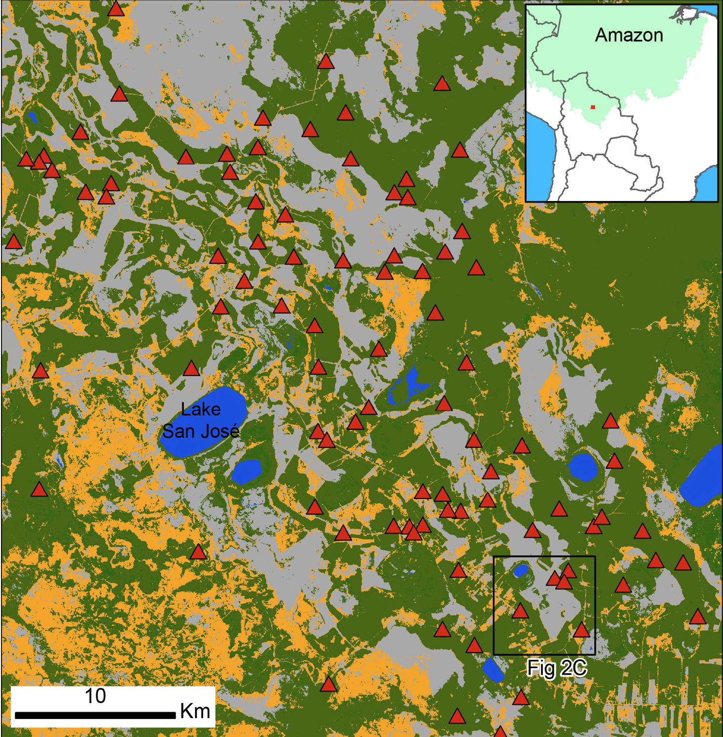
Nowadays, this region is at the forefront of the expansion of the agriculture frontier (Ormachea 2021), witnessing a sharp transition from cattle ranching to soy and rice production. This transition is having a large impact on the savanna, as land use is shifting from grazing to intensive, mechanized agriculture. Figure 1 shows the current land cover (based on Copernicus Sentinell-2 data, retrieved from Scientific Data Hub, Level-2A processed by ESA) of the central part of the MMR, with almost half of the savanna formerly used for cattle grazing now being cultivated. While slash and burn agriculture has been a common practice by Indigenous peoples in the forested areas, it is the first time since the collapse of the Casarabe culture that these savannas are being cultivated (Killeen et al. 2008).
Pre-Columbian agriculture in the MMR
When compared with the rest of the Amazon basin, the MMR has high agricultural potential because it is established on relatively recent fluvial sediments. Thousands of years ago, the Río Grande, a large river that today flows into the Mamoré River from east to west, followed a different course: it went from south to north, passing across the very area where the MMR is located. Due either to a change in climate conditions (Mayle et al. 2000) or a tectonic uplift (Lombardo 2014) the Río Grande started to repeatedly change its course, creating a delta-like environment at around 4 kyr BP. During this period of avulsions (i.e. rivers changing course because of floods outpacing natural margins or fluvial levees), the Río Grande deposited a huge amount of Andean sediments in what is now the MMR. Here, the Río Grande created two types of relief; a lens of sediments up to four meters thick over an area of approximately 2600 km2 that formed a sedimentary lobe, and a number of fluvial levees (Lombardo et al. 2012). The modern land cover of the MMR is the result of these geomorphological processes. Most of the sedimentary lobe is now covered by seasonally flooded savanna established over backswamp deposits, while the paleo-levees, which remain above the water level almost the whole year, are forested (Fig. 1).
 |
|
Figure 1: Land-cover classification of the central part of the Monumental Mound Region. The orange areas are covered with grass, and mostly represent open and dry savanna under cattle-ranching and deforested areas. The green is evergreen vegetation; mostly forest growing over the fluvial levees. The gray is bare soil; mostly recently plugged savannas for agriculture. Red triangles are monumental mounds. |
Modern agriculture in the MMR
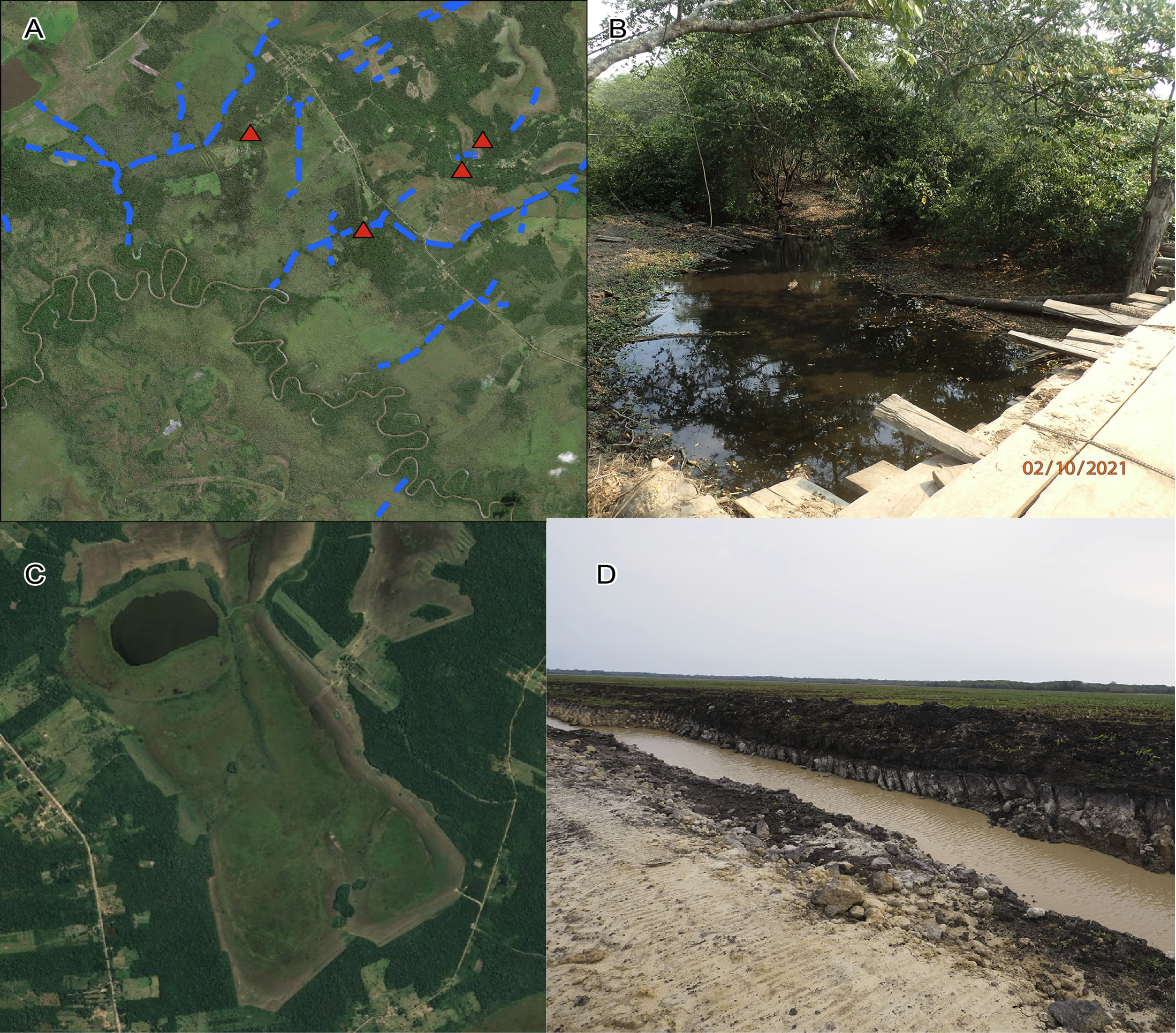
Even though most of the pre-Columbian drainage canals have been partially infilled with sediments, the overall network still plays an important role in speeding up drainage at the end of the rainy season. Figure 2b shows a picture of an active pre-Columbian drainage canal. Over the past years, this partially functioning drainage system has allowed farmers to cultivate the outer part of the savannas, along the border with the forest where the elevation is higher, while the inner part of the savanna has been left intact (Fig. 2c). By doing this, modern farmers have taken advantage of a pre-Columbian legacy.
 |
|
Figure 2: Land-use change in the Monumental Mound Region. (A) Pre-Columbian drainage canals (blue) take water from the savanna to the Ibare River (Lombardo et al. 2012). (B) Photo of a still functioning pre-Columbian drainage canal. The canal is six meters wide and three meters deep. (C) Satellite image taken in 2021. The brownish/gray areas along the forest shows savanna being cultivated. In 2022 (see Fig. 1), the whole savanna was plugged and planted with soybeans. (D) Modern drainage canal excavated in 2022, draining the savanna in (C). Note that the modern canal is cutting through a pre-Columbian one, visible as the black profile along the right margin of the canal. |
More recently, however, farmers have started to cultivate the whole savanna. By excavating new drainage canals (Fig. 2d), farmers are now draining the deeper part of the savanna. The peat accumulated over the last few centuries is now drying, and it will be later burnt with the consequential release of tons of CO2 into the atmosphere. What in pre-Columbian times was a collective effort of landscape transformation and management that probably took decades to implement, is now a large-scale, land-use change that only requires a few months of intensive tractor use. Yet, objectives and results are basically the same: draining the wetlands to make space for agriculture.
affiliations
1Institut de Ciència i Tecnologia Ambientals (ICTA-UAB), Universitat Autònoma de Barcelona, Spain2Department of Prehistory, Universitat Autònoma de Barcelona, Spain
contact
Umberto Lombardo: umberto.lombardo@uab.cat
references
Boivin N, Crowther A (2021) Nat Ecol Evol 5: 273-284
Dickau R et al. (2012) J Archaeol Sci 39: 357-370
Killeen TJ et al. (2008) Ecol Soc 13: 36
Lombardo U (2014) Earth Surf Dynam 2: 493-511
Lombardo U et al. (2012) The Holocene 22: 1035-1045
Lombardo U et al. (2013) Quat Int 312: 109-119
Lombardo U, Prümers H (2010) J Archaeol Sci 37: 1875-1885
Mayle FE et al. (2000) Science 290: 2291-2294
Fire–climate–human relationships in Australian tropical savannas are poorly understood in pre-industrial periods, particularly at centennial to millennial time-scales. Stalagmites from a cave in the Kimberley region hold the potential for high-resolution paleofire reconstruction from pyrogenic organic compounds spanning these timescales.
A need for novel, high-resolution paleofire records in Australian tropical savannas
The history of human management of fire in Australia dates to at least 50 kyr BP (Wurster et al. 2021). However, existing paleofire reconstructions are sparse, both temporally and spatially heterogeneous, and often poorly resolved. This limits our ability to assess the relative impacts of climate and Aboriginal land and fire management on ecological change. Nonetheless, long-term human influences on vegetation and fire frequency are widely demonstrated (Vigilante et al. 2009). At the end of the 18th century, European settlers in southeastern Australia modified interactions between natural drivers of fire and Indigenous management. This led to changes in patterns of fire regimes, which likely contributed to the decline of land mammals and fire-sensitive plants observed throughout the country (e.g. Bowman et al. 2022; Woinarski et al. 2015).
In the fire-prone tropical savannas of northwestern Australia, the lack of long-term, high-resolution paleofire reconstructions is particularly acute. This is due to a scarcity of permanent water bodies and other undisturbed depositional environments suitable for the preservation of biomarkers or paleoecological proxies, such as charcoal and pollen (Wurster et al. 2021). For this reason, exploring the potential of novel, highly resolved, and stable archives is of increasing interest.
Stalagmites from limestone caves are a widely used paleoclimate archive, given that they can grow continuously for thousands of years, resist alteration, enable the use of precise dating methods, and provide high-resolution paleoenvironmental information through different proxies. Stable isotopes of oxygen and carbon, along with trace elements (e.g. Mg, Sr, U), are the main geochemical proxies used in speleothems for paleoclimate reconstruction, most notably paleomonsoon reconstruction (Denniston et al. 2016). The study of organic compounds (e.g. lipids, phenols, and aromatic hydrocarbons) in speleothems is less well developed, despite their potential to preserve paleoenvironmental signals unattainable by inorganic compounds (Blyth et al. 2016).
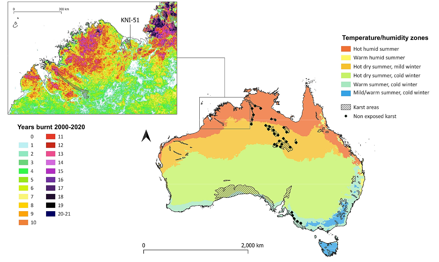
Caves exist across many parts of Australia, including the tropical areas. An extended, exposed limestone area (Fig. 1) is present in the Kimberley region of northwestern Australia, where the richness in rock art sites documents early human settlement, with some of the oldest paintings dating back to 40 kyr BP. Here, aboriginal management based on localized small-scale burning is believed to have allowed fire regulation and the conservation of fire-sensitive flora and fauna, in contrast with European practices promoting further burning and ecological losses (Yibarbuk et al. 2001). Our research aims to extract records of paleofire activity from Kimberley stalagmites, at near annual resolution, to shed light on complex fire–climate–human relationships in the last millennium, when this abrupt shift in the fire-ecology equilibrium occurred.
Fire proxies in speleothems
Paleofire reconstruction from stalagmites is currently taking its first steps, and is rapidly accelerating, as demonstrated by recent studies where Holocene fire activity in different regions worldwide was investigated through inorganic and organic geochemical proxies. For instance, McDonough et al. (2022) associated peaks in P, Al, Zn, and Cu in a southwest Australian stalagmite to known fire events and prescribed burns, while Homann et al. (2022) related traces of the organic compound levoglucosan in a stalagmite from California to hydroclimate and fuel availability that promoted changes in early Holocene fire activity.
Previous work by Argiriadis et al. (2019) presented a method for the analysis of trace polycyclic aromatic hydrocarbons (PAHs) and n-alkanes in stalagmites. These organic compounds reflect biogeochemical processes occurring at the land surface, in the soil, and in the cave. PAHs are primarily related to combustion of biomass, while n-alkanes, with their potential for vegetation reconstruction, provide information on fuel availability and composition. These target organic molecules are carried into the underlying cave by infiltrating water, and finally incorporated into speleothems; thereby, creating the potential for speleothems to serve as novel paleofire archives.
PAHs are organic molecules composed of two or more fused aromatic rings and result from incomplete combustion of organic materials. According to fuel and combustion conditions, a wide range of PAHs are associated with biomass burning. Immediately after fires of moderate intensity (200–400°C), abundance of light and medium molecular weight (LMW and MMW, respectively) compounds are elevated in burnt soils, while high molecular weight PAHs (HMW) are rare to absent (Rey-Salgueiro et al. 2018). HMW PAHs are generally only produced at temperatures higher than ~500˚C and are, thus, associated with fossil fuel combustion or very intense fires of woody material (Wang et al. 2017). PAHs are highly persistent in the environment but have generally low concentrations in natural waters due to their low solubility, while soil PAHs are, for the most part, adsorbed onto organic matter-specific sites.
To date, the only known attempt to use PAHs for stalagmite fire reconstruction was performed by Perrette et al. (2008), although the study faced some difficulties due to the complex nature of thick soils and depth of the cave, and, thus, did not yield conclusive paleoenvironmental information. In contrast, cave KNI-51, located in the Kimberley region (tropical northwestern Australia) (Fig. 1), appears to be an ideal setting for the rapid transportation of organic compounds from the land surface to the underlying cave, given that it is a shallow location, covered by thin soil, and permeable and fractured limestone. Stalagmites at cave KNI-51 are also well-suited for this work, as they show high growth rates (1–2 mm yr-1) and yield extremely high precision 230Th dates (2 SD errors = ±1 year over most of the last century), which together offer high (1–3 yr) temporal resolution for PAH measurements.
 |
|
Figure 1: Australian climate zones (source: Australian Government Bureau of Meteorology, bom.gov.au) with karst areas distribution (source: World Karst Aquifer Map, whymap.org). Kimberley region with fire frequency and cave KNI-51 location (source: NAFI, North Australia & Rangelands Fire Information, firenorth.org.au). |
We analyzed PAHs in three aragonite stalagmites from cave KNI-51. The stalagmites grew during different intervals of the last millennium, and include one that spans most of the period between 1750–2009 CE (KNI-51–11). This time interval encompasses the arrival of European pastoralists in the Kimberley region in the late 19th century.
Comparison with satellite data
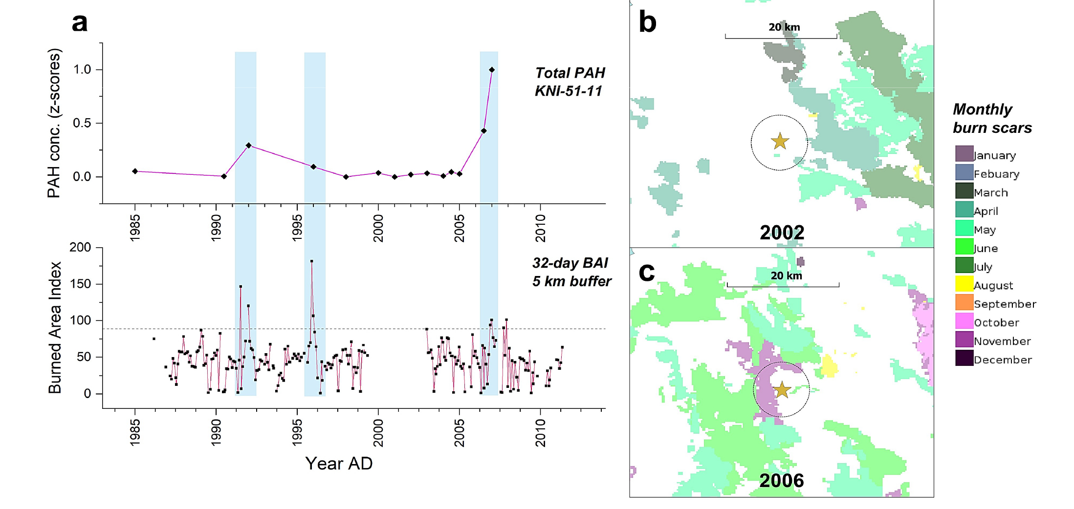
PAH concentrations in the interval between 1984 and 2007 were compared with the Burned Area Index (BAI), a satellite-derived spectral index obtained from near-infrared reflectance (Chuvieco et al. 2010), computed through Google Earth Engine (GEE) using Landsat 5 Collection 1 Tier 1 images. High normalized PAH concentrations in stalagmite KNI-51–11 coincide with values in the 32-day BAI composite within a 5 km radius around the cave ≥89, which corresponds to the threshold identified by Martin et al. (2005) as indicative of burned areas (Fig. 2). Although differences in resolution between the BAI and PAH records must be considered (BAI composite is given here with a 32-day frequency, while average PAH resolution, although remarkable for a stalagmite record, is 1.6 yr), together with dating uncertainties, the stalagmite PAH record shows potential to capture the signal from bushfires occurring close to the cave, especially in the late dry season (September–November), as shown in high resolution fire–scar maps (Fig. 2). Although preliminary, this finding is a first indication of the validity of our method for long-term fire reconstruction.
 |
|
Figure 2: (A) Total PAH concentrations (z-scores) from stalagmite KNI-51-11 (top), and 32-days composite of the Burned Area Index within a 5 km radius around the cave (bottom). (B) Monthly fire scars (areas of blackened land surface following vegetation fires identified through MODIS 250m satellite imagery) in the cave area in year 2002, and (C) in 2006 (source: NAFI, North Australia & Rangelands Fire Information, firenorth.org.au). |
Future work
As the use of speleothems as a paleofire proxy is in its infancy, several important tests are underway. First, we continued to analyze coeval stalagmites from the same cave to assess the degree of replication in PAH values and trends. Second, during cave floods events, stalagmite caps are coated with sediment, some of which is incorporated into the stalagmite when flood waters recede and stalagmite growth resumes, thus possibly acting as an additional source of organic compounds to the cave. Defining contributions of flood sediment to measured PAH abundances and distributions is critical to define the paleofire signal. Third, the transport of PAHs from the land surface to the cave is not well understood, so a prescribed burn and irrigation experiment will soon be performed to address this and related questions. Finally, contributions of organic compounds from regional oil fields, while extremely unlikely, will be examined as a potential source of contamination through analysis of benzene polycarboxylic acids (BPCA).
affiliations
1CNR-ISP, Institute of Polar Sciences, National Research Council of Italy, Venice, Italy2Department of Environmental Sciences, Informatics and Statistics, University of Venice, Italy
3Department of Geology, Cornell College, Mount Vernon, USA
4School of Natural Sciences, University of Tasmania, Sandy Bay, Australia
contact
Elena Argiriadis: elena.argiriadis@cnr.it
references
Argiriadis E et al. (2019) Anal Chem 91: 7007-7011
Bowman DMJS et al. (2022) Sci Rep 12: 9081
Chuvieco E et al. (2010) Int J Remote Sens 23: 5103-5110
Denniston RF et al. (2016) Sci Rep 6: 34485
Homann J et al. (2022) Nat Commun 13: 7175
McDonough LK et al. (2022) Geochim Cosmochim Acta 325: 258-277
Perrette Y et al. (2008) Chem Geol 251: 67-76
Rey-Salgueiro L et al. (2018) L Degrad Dev 29: 2112-2123
Vigilante T et al. (2009) In: Cochrane MA (Ed) Tropical Fire Ecology. Springer, 143-167
Wang C et al. (2017) Org Geochem 114: 1-11
Woinarski JCZ et al. (2015) Proc Natl Acad Sci 112: 4531-4540
Landscape transformation by Maya civilization represents one of the most significant anthropogenic environmental changes in the pre-colonial Americas. Using lake sediments, we address how the evolution of a karstic lake has been affected by human–environment interactions over the last 8300 years.
The Maya civilization developed and thrived in the region of the Yucatan Peninsula (México, Guatemala, and Belize) from ~4000–500 yr BP (before present). The Puuc region, located at the northwest of the peninsula, was a key area for human settlements, as it harbors some of the most productive soils in the Maya lowlands (Fig. 1).
 |
|
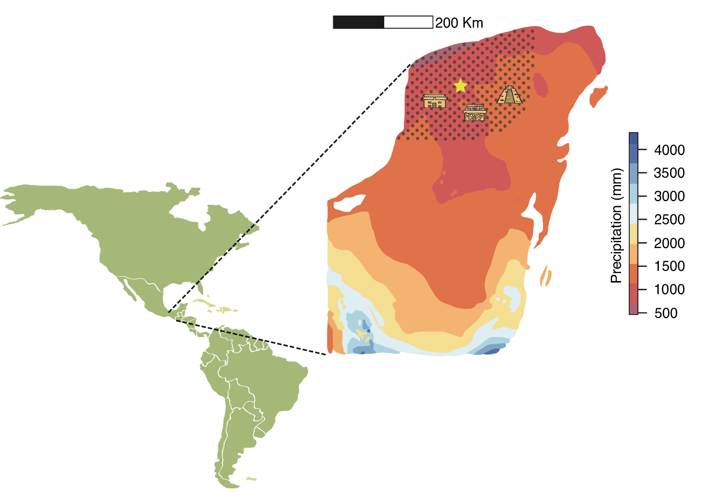
Figure 1: Location of the Yucatan Peninsula showing the modern mean annual rainfall distribution (Fick and Hijmans 2017). The Puuc region (marked dotted area) and Lake Yalahau (yellow star). Buildings symbolize main archaeological sites from the Puuc region, from left to right: Oxkintok, Uxmal, and Chichén Itzá (Illustrations by Ariadna Valenzuela-Zuñiga). |
We recovered a 560-cm-long sedimentary sequence from the deepest part of Lake Yalahau using a modified Livingstone piston corer. Here, we used elemental concentrations and geochemical analysis of organic matter to explore mechanisms of underlying changes in lake evolution. A principal component analysis (PCA) was applied to elemental and geochemical proxy data to summarize environmental variability through time in Yalahau. This technique summarizes the geochemical signals in principal components (PC) that are interpreted as representing climatic and/or environmental drivers, and can be used to infer the environmental evolution of the lake throughout the different cultural stages of the Maya civilization. Major geochemical trends of Lake Yalahau were described in terms of changes in erosion in the catchment (PC1) and lake productivity (PC2) (Fig. 2). Detrital elements (iron and rubidium) were located along negative PC1 values, while authigenic elements (calcium and strontium) were located along positive PC1 values.
 |
|
Figure 2: Paleoenvironmental synthesis of Lake Yalahau over the last 8300 years based on changes in productivity (PC2 scores) and erosion (PC1 scores). The Maya chronology is shown on the left side (Illustrations by Ariadna Valenzuela-Zuñiga). |
Maya Archaic (8300–4000 yr BP)
The infilling of Lake Yalahau and other lakes in the northern Yucatan Peninsula started at around 8000 yr BP. This process was probably related to regional sea-level rise and a higher moisture availability during the early Holocene in the Northern Hemisphere (Haug et al. 2001; Milliken et al. 2008). PC2 positive scores suggest low productivity conditions in Lake Yalahau (Fig. 2). Humid conditions prevailed at the end of the early Holocene, enabling the establishment of deciduous forests in the northwest of the Yucatan Peninsula (Leyden 2002). This vegetation cover probably protected the soil from erosive agents, explaining the low erosion rates observed in Yalahau from 7000–4000 yr BP through soil stabilization (Koinig et al. 2003). Archaeological remains indicate the presence of hunter-gatherers in the Maya Lowlands during the Archaic period (Hoggarth et al. 2016). However, pollen records show relatively pristine vegetation during this period, implying anthropogenic effects on the environment would have been minimal or limited in their spatial extent (Leyden 2002).
Maya Preclassic (4000–1700 yr BP)
Evidence of the first permanent settlements in the Puuc region dates to the Middle Preclassic (Hoggarth et al. 2016). In Lake Yalahau, decreasing PC1 scores indicate increasing erosion probably associated with land-use changes (Fig. 2). The input of allochthonous nutrients, in turn, resulted in increased lake productivity reflected in changes in PC2 scores. The evidence suggests that deforestation and agriculture were extensive practices throughout the Yucatan Peninsula during the Preclassic (Anselmetti et al. 2007; Leyden 2002; Wahl et al. 2006). Also, lake sediments recorded several pronounced regional droughts (Hodell et al. 2001) that coincide with changes in vegetation cover in Yalahau during the middle to late Preclassic.
Maya Classic (1700–1000 yr BP)
During the Classic period, increased erosion in the basin and eutrophication of Lake Yalahau are indicated by both negative PC1 and PC2 scores. These findings coincide with the development of "classic" Puuc architecture in city-states near the lake (i.e. Uxmal), corresponding to a large-scale human occupation of the region (Dunning et al. 2013). Regional paleoclimate records from speleothems and lake sediments show successive droughts during the Terminal Classic that coincide with societal collapse of some city-states in the southern Maya Lowlands (Hodell et al. 2001; Medina-Elizalde et al. 2010). However, archaeological evidence shows an apogee of Puuc sites during the Terminal Classic period. Puuc settlements developed urban reservoirs (aguadas) and underground cisterns (chultunob) for water storage. These water management strategies may have allowed the Puuc populations to deal with droughts better than in other areas of the Maya Lowlands (Dunning et al. 2013; Hoggarth et al. 2016).
Maya Postclassic (1000–400 yr BP)
Regional paleoclimate records indicate a severe drought during the early Postclassic that coincides with the decline of construction of monuments and hieroglyphic inscriptions at the Puuc urban centers (Dunning et al. 2013; Hodell et al. 2001; Medina-Elizalde et al. 2010). Hoggarth et al. (2016) suggest a shift in occupation to sites along the coast and nearby freshwater ecosystems such as lakes and rivers during the Postclassic period. The access to perennial water resources, such as those provided by Lake Yalahau, could favor settlements around the lake. During this interval, productivity and erosion rates increased, reaching their maximum throughout the Yalahau record. Also, an increase in tropical hurricanes in this interval would explain enhanced soil erosion and allochthonous sediment input into the lake (Schmitt et al. 2020).
Colonial (400 yr BP–Present)
Our record indicates that the last 400 years have been characterized by high erosion rates and a substantial decrease in productivity in Lake Yalahau. These patterns have been associated with increased regional moisture availability and high cyclonic activity (Medina-Elizalde et al. 2010; Schmitt et al. 2020). Environmental degradation associated with human activities coupled with droughts and hurricane effects could explain a decline in the population throughout the Puuc region at the end of the Postclassic period and during Colonial times (Dunning et al. 2013; Schmitt et al. 2020).
Our study illustrates the importance of studying the evolution of these karstic lakes to understand long-term environmental changes in the Maya Lowlands. The sedimentary record of Lake Yalahau shows that anthropogenic environmental degradation may have been one of the main drivers of ecological change since the Preclassic period in the Puuc region. Further archaeological and paleolimnological studies, focused on the human–impact proxies (i.e. pollen and charcoal) and responses of karstic lakes to anthropogenic degradation, will contribute to a better understanding of human–environment interactions in the Maya Lowlands.
Acknowledgements
This research was funded by project DGAPA-UNAM IG100722 "Una aproximación multi-indicador y multi-registro a la variabilidad ambiental de la Península de Yucatán a través del Holoceno".
affiliations
1Posgrado en Ciencias del Mar y Limnología, Universidad Nacional Autónoma de México, Ciudad de México, México2Department of Earth Sciences, Indiana University-Purdue University, Indianapolis, USA
3Centro de Geociencias, Universidad Nacional Autónoma de México, Queretaro, México
contact
Alejandra Rodriguez-Abaunza: glarodri@iu.edu
references
Anselmetti FS et al. (2007) Geology 35: 915-918
Dean WE (1999) J Paleolimnol 21: 375-393
Dunning N et al. (2013) Diálogo Andino 41: 171-183
Fick SE, Hijmans RJ (2017) Int J Climatol 37: 4302-4315
Haug GH et al. (2001) Science 293: 1304-1308
Hodell DA et al. (2001) Science 292: 1367-1370
Hoggarth JA et al. (2016) Glob Planet Change 138: 25-42
Koinig KA et al. (2003) J Paleolimnol 30: 307-320
Leyden B (2002) Anc Mesoam 13: 85-101
Medina-Elizalde M et al. (2010) Earth Planet Sci Lett 298: 255-262
Past societies have much to teach us about ways of dealing with environmental change. New techniques in landscape reconstruction and ancient DNA are shining a light into the past and revealing how people and environments shaped each other.
Real understanding of past societies can only come with a holistic view of their place in the world. Today’s societies rely so heavily on technology and human-modified environments that we sometimes imagine we act separately from the ecosystems that support us. We need only to look at the economic and health impacts of recent extreme weather, fires, and floods to see how wrong this view can be. The environment shapes how we understand ourselves as humans. In fact, it is humanity’s lived experience of past environments that has led to today’s environmental knowledge.
Why situate past societies in their environments?
The link between past experience and present knowledge is what makes the study of past societies and environments so important. Although each day brings new situations, we can all benefit from the experience handed down to us, regardless of whether it was from yesterday or thousands of years ago. Today’s technology-saturated societies might imagine that the further we go back into the past, the more direct the relationship between people and their environment. But delving into that relationship is not a straightforward task and becomes more difficult the deeper in time we go. The scientific evidence is often indirect, fragmented and murky.
Archaeologists study this fragmented evidence to understand past societies, and paleoecologists delve into mud to understand past ecosystems. By talking to each other, we can work towards a shared understanding. Bringing these two fields together presents a number of challenges, however. Reconciling issues of different spatial scale, different timescales and different scholarly mindsets can frustrate attempts to investigate past socio–environmental systems.
Insights from land-cover modeling
New techniques promise to relieve some of these frustrations. One particularly promising field is land-cover modeling, which turns pollen sequences into realistic estimates of vegetation cover and composition. Land-cover modeling can reveal the extent of past modification of ecosystems by humans, rewriting the history of human activity on the Earth’s surface. This can be achieved on various scales, from continental to local, depending on the human–environment interactions of interest. Researchers interested in the major turning points in human history, such as migrations and the emergence of agriculture, might require information about past vegetation on a continental scale. An example of this is a land-cover reconstruction from Europe, which tracks the shifting distribution of Holocene forests, and the rapid expansion of agricultural land across the continent (Githumbi et al. 2022). Reconstructions on this scale provide data that can be compared to archaeological evidence and climatic shifts reconstructed from various paleo-proxy data.
On a regional scale, land-cover modeling can show how ancient cultural practices, like deliberate burning, modified the vegetation. In Australia, for instance, there are few suitable trees for fire-scar studies, meaning there is little information about past fire regimes. Using land-cover modeling, researchers were able to reconstruct past vegetation, showing that Indigenous people created forest environments that were grassier than they are today (Mariani et al. 2022). This information can be useful in managing Australia’s wildfire problem. In Czechia, land-cover modeling showed how generations of scientists have made the mistake of thinking spruce forests are recent introductions, rather than the ancient forest ecosystems new evidence shows them to be (Abraham et al. 2016). How we manage these forests depends very much on what we know about their history.
At the local scale, researchers can use land-cover modeling to distinguish between local human activities around archaeological sites, and environmental change occurring across the broader region. In Norway, researchers found that trees covered only 5–10% of the landscape near settlements during periods when the area was densely populated, compared to around 50% tree cover across the landscape as a whole (Hjelle et al. 2022). Tree cover expanded after settlements were abandoned (Fig. 1). This level of detail allows us to begin to imagine how our ancestors interacted with their surroundings, adopting different attitudes and practices in near and distant zones.
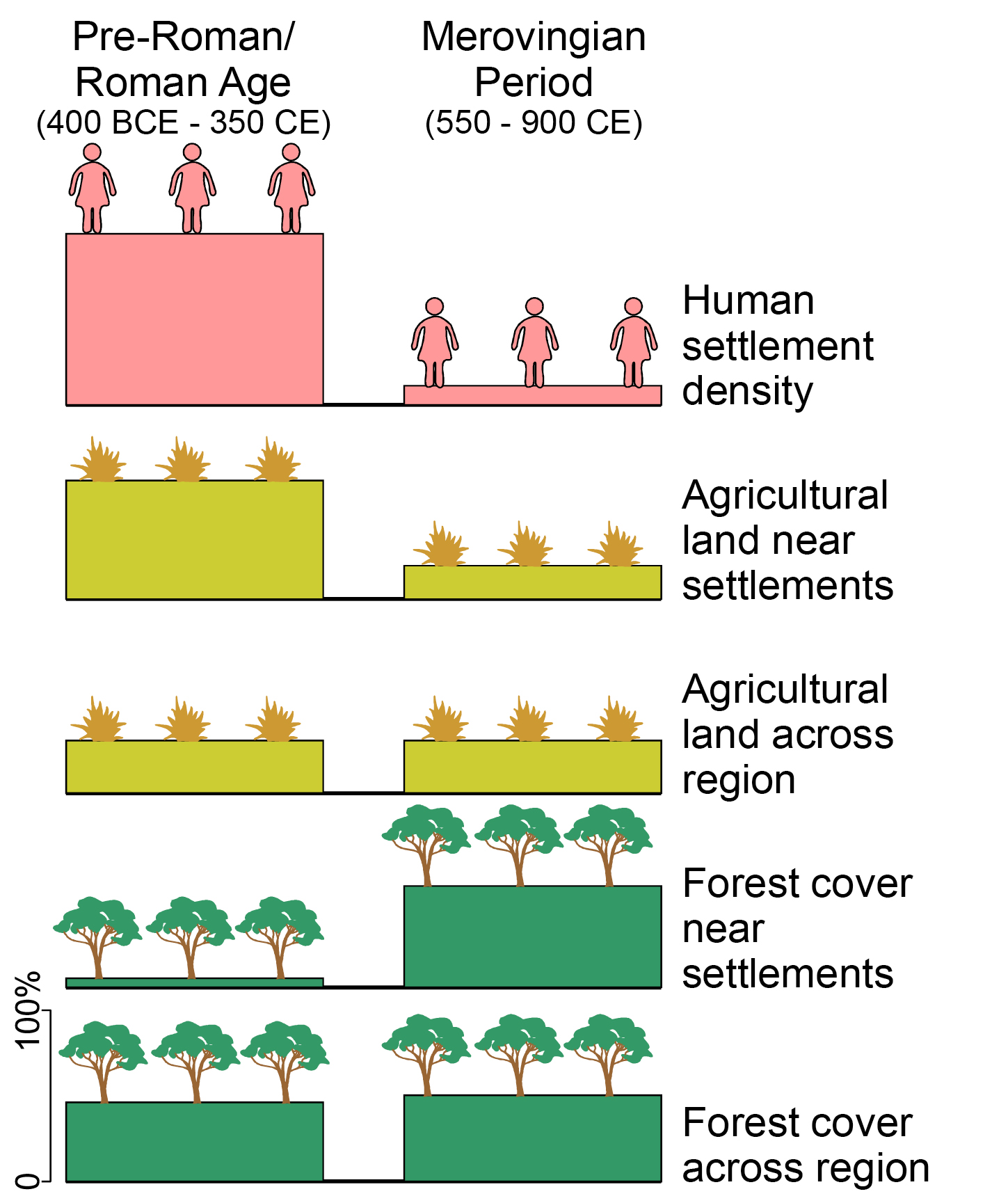 |
|
Figure 1: Changes in human settlement, agricultural land and forest cover in Central Norway, showing how land-cover modeling can be used to reconstruct past vegetation at local and regional scales. Modified from Hjelle et al. (2022). |
Ancient DNA
Ancient DNA is another approach with enormous potential for situating past societies in their environment. Despite its ability to uncover past biological diversity in unprecedented detail, ancient sedimentary DNA (sedaDNA) is subject to biases (e.g. preservation) that can make its interpretation difficult (Edwards 2020). For this reason, it is preferable to use sedaDNA alongside other proxies, including traditional indicators like pollen, but, also emerging proxies like lipid biomarkers, as unequivocal human traces.
An example is a study of a medieval archaeological site in Ireland, where researchers were able to use sedaDNA, novel biomarkers, and other proxies in lake sediments to investigate how people used plants and animals in the past (Brown et al. 2021). Unexpected details of animal husbandry and butchering were revealed from multiple lines of evidence, as well as clear signs of deforestation and the cultivation of plants that are rarely, or imprecisely, identified from fossil pollen. Importantly, their approach had no impact on the archaeological site itself, and, unlike an excavation, it tells us what happened at the site prior to site formation and after site abandonment. In this way, we can begin to understand why people established a settlement, and why they eventually left.
Another example of the use of sedaDNA comes from the Swiss Alps, where researchers discovered that pastoral activity had been a key driver of alpine plant diversity for thousands of years (Garcés-Pastor et al. 2022). Unlike some pollen grains that can spread long distances in the air, sedaDNA most likely comes from the catchment area, and it provides additional information on animal occupation. This makes sedaDNA a very useful indicator of local change in vegetation. The researchers found evidence for changing pastoral practices against a background of vegetation change. People shifted from a reliance on wild fauna to domesticated sheep, goats and cattle through a succession of archaeological periods (Fig. 2). This kind of research shows how different societies in the past were able to balance agriculture, pastoralism, forest resources, and habitat diversity to create unique subsistence patterns in space and time, allowing them to adapt to a dynamic environment.
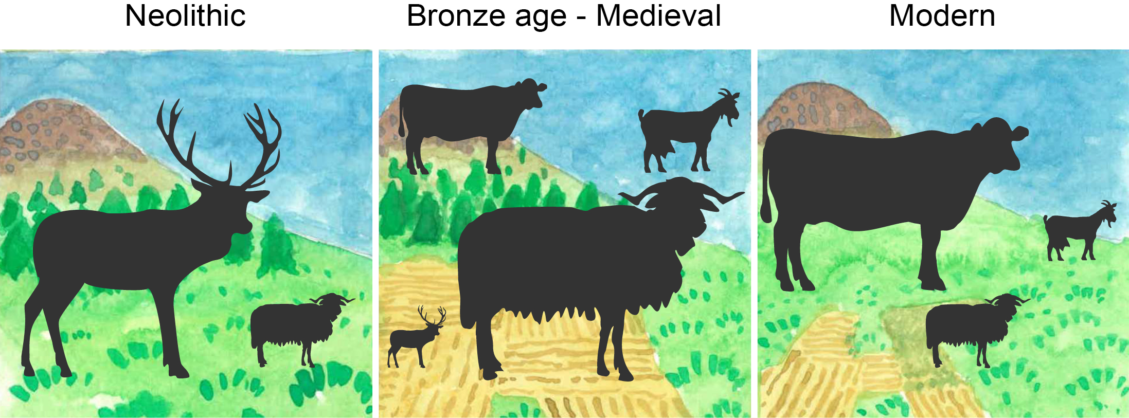 |
|
Figure 2: Grazing animals at different periods in the Swiss Alps, from the ancient DNA of red deer, sheep, cows and goats found in lake sediments. The size of each animal symbol represents its contribution to overall DNA, and the background symbolizes vegetation changes. Modified from Garcés-Pastor et al. (2022). |
Suitable archaeological contexts can also yield ancient DNA. In an example from Greenland, researchers used DNA analysis of small bone fragments to find out what Inuit and Norse populations were eating (Seersholm et al. 2022). This research revealed a rich diversity of prey, including many species from the land and sea that are rarely, if ever, preserved or found in archaeological sites. This gives researchers new tools for understanding how people interacted with other species, hinting at the human intelligence that must have been needed to understand, capture and prepare so many different species from their environment.
The examples above come from relatively cool, wet environments, but sedaDNA also has potential in semiarid environments with much longer histories of human occupation, such as the African savanna (Tabares et al. 2020). Along with other new proxies, ancient DNA seems to set the stage for a renewal in how we conceptualize the past.
Better research
Like any new tool, there are important limitations and ethical issues that come into play, especially when dealing with the cultural and genetic heritage of Indigenous peoples. Scientists can often be blind to the deep and intangible cultural associations that belong to certain places and things. There are various frameworks that can guide a more considerate approach to research (de Freitas et al. 2022). It could involve taking a different perspective – seeing landscapes and sites as biocultural heritage (Ekblom et al. 2019) and acknowledging that all environments, despite their apparent "wilderness", are places humans have modified to varying degrees (Fletcher et al. 2021). Or it could involve taking a truly collaborative and ethical approach – one that requires researchers to adopt research practices developed with, and by, Indigenous communities, or to co-design research directly with the communities themselves (AIATSIS 2020; Copes-Gerbitz et al. 2022; de Freitas et al. 2022).
As researchers, we need to remain mindful of the people who created and maintained complex socio–environmental systems over millennia. While new technology and techniques hold much promise, a truly holistic view requires us to consider multiple sources of evidence, and to learn from the descendants of the societies and environments we are trying to study.
affiliation
School of Culture, History and Language, Australian National University, Canberra, Australiacontact
Simon Connor: simon.connor@anu.edu.au
references
Abraham V et al. (2016) Preslia 88: 409-434
Brown A et al. (2021) Sci Rep 11: 11807
Copes-Gerbitz K et al. (2022) PAGES Mag 30(1): 48-49
de Freitas KM et al. (2022) PAGES Mag 30(1): 50-51
Edwards ME (2020) Quat Res 96: 39-47
Ekblom A et al. (2019) Land 8: 5
Fletcher M-S et al. (2021) Proc Nat Acad Sci 118: e2022218118
Garcés-Pastor S et al. (2022) Nat Commun 13: 6559
Githumbi E et al. (2022) Front Ecol Evol 10: 795794
Hjelle K et al. (2022) Front Ecol Evol 10: 911780
Mariani M et al. (2022) Front Ecol Environ 20: 292-300
Co-developing paleoscience research questions is associated with effective collaboration challenges. We discuss a framework that brings together past socio–environmental processes and proxies to foster future interdisciplinary collaborations.
Quaternary records of environmental change
The multivariate nature of environmental changes recorded in Quaternary records informs and enhances our knowledge of past interrelated human and climatic systems. This knowledge is usually inferred from natural archives of paleoenvironmental change (e.g. lake sediments, peat, speleothems, tree rings) which contain evidence in the form of biological, chemical, and physical remains or proxies. Proxies can reconstruct different biotic or abiotic variables (e.g. temperature, precipitation, etc.), which may also be controlled by anthropogenic (e.g. agriculture, land use, deforestation) and non-anthropogenic (e.g. climatic variability, volcanic eruptions, etc.) drivers. The distinction between natural and anthropogenic drivers can be partially disentangled by analyzing paleo proxies, along with archaeological evidence, which provides insights into how, when, and where humans occupied, utilized, and influenced their environment. Yet their interpretation is complex due to their intricate multivariate nature, which often leads to conclusions drawn by simplistic approaches, generating intense debates in the science community (Rull 2018).
Some Quaternary studies have claimed that past environmental events, inferred from proxy data, drive identifiable changes in the archaeological and historical records; so-called correlation means causation. While environmental determinism – societal trajectories being predisposed by physical environment change – is defended by some paleoclimatologists, the criticism comes mostly from the social side of paleoscience (archaeologists, historians) (Coombes and Barber 2005). This type of simplistic determinism survives because of the difficulty of co-developing research questions from different disciplinary backgrounds that are rooted in disparate theoretical perspectives (e.g. humanistic and scientific), methodologies (e.g. theory-driven and data-driven), and multiscale processes (long-short temporal scales) (Silva et al. 2022). The most important challenge in synthesizing paleoecological, paleoclimatological, and archaeological research is to interpret multiple types of data while integrating them in a comparable framework that considers their different temporal and spatial coverage.
In this article, we present a framework to help researchers integrate proxies at the nexus of coupled human–environmental systems (Fig. 1).
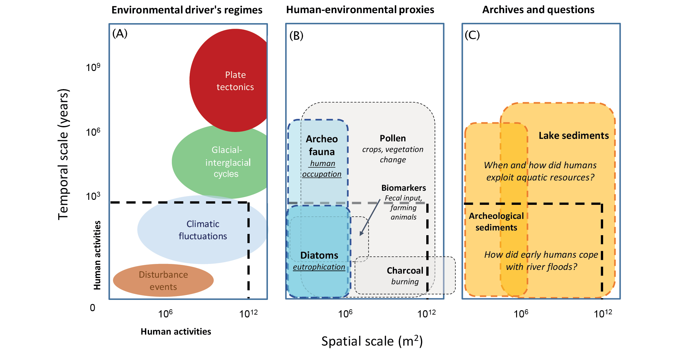 |
|
Figure 1: Framework to integrate proxies at the nexus of coupled human–environmental systems. Integration of (A) environmental driver’s regimes, (B) human–environmental proxies to address them, and (C) archives and questions used in the text. The spatiotemporal scale for each environmental regime, including the scale of human disturbance (dashed black rectangles), and the archives and proxies discussed in the text, reflect the resolution required to study it. Adapted from Delcourt and Delcourt (1983). Note: 106 m2 is equivalent to local scale (e.g. the size of a lake), and 1012 m2 is equivalent to a regional scale (e.g. the size of a continent). |
Diatoms, paleoecology, and archaeology in the high Andes
Diatoms – unicellular siliceous algae – have been widely used in aquatic ecosystems to infer past changes in climate, land use, and/or water quality that are relevant to archaeological investigations (Smol and Stoermer 2010). A possible application of diatoms in archaeological research is to study aquatic-terrestrial relationships under the influence of humans. Diatoms react sensitively to changes in water nutrients, which are often a direct function of the surrounding landscape via biochemical fluxes of detrital sediments and organic matter. Human practices, by means of terracing, can modify those aquatic-terrestrial relationships. Lake Llaviucu (Fig. 2) is located in the tropical Andes, where an important trade route connecting the highlands of Ecuador with the Amazon lowlands was operated by pre-Inca (3700–471 yr BP) and Inca societies (480–420 yr BP).
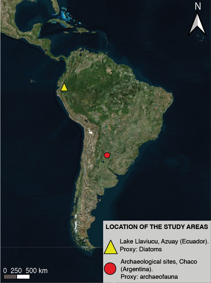 |
|
Figure 2: Geographical location of the two study cases presented in the main text. The yellow triangle indicates Lake Llaviucu. The red dot indicates the distribution area of the archaeological sites of the Argentina Gran Chaco. |
Archaeofauna as a paleoproxy in the Argentinian Gran Chaco
Recently, the use of novel zooarchaeological analysis has begun to shed light on the pre-Hispanic human occupation of the Gran Chaco region in Argentina, and its paleoenvironmental evolution, which historically had been inferred using evidence from other areas. The sites of the Argentinian Gran Chaco (Fig. 2) have sequences of human occupation throughout the late Holocene, from 1800 to 600 yr BP (Lamenza et al. 2019). The site "El Cachapé Potrero IV B", studied by Zarza et al. (2019), shows evidence of more than one diachronic human occupation. The temporal frequencies of the archaeofauna record indicate a reduction in the consumption of deer and an increase in fish consumption between 1700 yr BP and 900 yr BP. This, added to other lines of evidence (distribution of sites and ceramic variability) suggest a reduction in areas of resource procurement since 1000 yr BP.
Morphometric analysis of fish remains (Zarza et al. 2022) shows an increasing trend in size over time. This variation can be interpreted as a gradual improvement in favorable environmental conditions for fish communities, such as small variations in lake levels, high dissolved oxygen, food availability, larger size of water bodies and/or smaller fish populations. Zarza et al. (2023) also demonstrated that variability in fish pectoral spines from the species Hoplosternum littorale can be used as an indicator of seasonal resource exploitation by humans. Rainy seasons favor the development of a particular morphotype of pectoral spine of H. littorale (Hostache and Mol 1998). Thus, its presence in the archaeological record could indicate that the Chaco people were hunting fish during the rainy season (between October and April). These results highlight the importance of ichtio-archaeological studies to infer both past environmental conditions and the use of aquatic resources (Santini 2009; Zarza et al. 2019).
The importance of scale when integrating paleoecology and archaeological proxies
Humans, climate, and the environment are inextricably linked. The case studies presented here emphasize various spatial and temporal scales recorded by different proxies (diatoms and archaeofauna; Fig. 1b), and archives (lake sediments and archaeological sedimentary matrix; Fig. 1c) (Holdaway and Wandsnider 2008). For example, high-elevation lakes in the tropical Andes are naturally fishless. Under this context, a study of fish skeletal remains from nearby archaeological deposits may indicate resource transportation and human movements. Changes in diatom assemblages from archaeofaunal deposits may also help to identify the provenance of fish (e.g. active dispersers) and their local habitat (riverine or lacustrine), providing new insights into aquatic resource strategies. For the case of Lake Llaviucu as explained above, its land-use history needs to be compared with independent proxies of human occupation (e.g. fecal biomarkers and charcoal) to evaluate the hypothesis of terracing and aquatic fauna exploitation in the valley, considering that these processes act at different spatiotemporal scales (Fig. 1b).
Human settlements in the Chaco are located in dynamic riverine regions. Thus, lacustrine sediment cores have the potential to improve our understanding of the intrinsic relationship between aquatic and terrestrial environments, and past human societies. The potential contribution of diatom analyses to this case study can provide nuanced climatic and environmental contexts under which Chaco’s Late Holocene societies lived and adapted. The presence of riverine diatom taxa, for example, would indicate wet conditions, which if compared with regional archaeological excavations and nearby pollen records, would provide information on human practices in the event of major river floods. Increasing the number of radiocarbon dates from the Chaco region and adding higher-resolution paleoclimatic proxies (e.g. sub-decadal) may also help to further elucidate relationships between the use of aquatic resources and human–environment dynamics.
As a conclusion, we highlight the need to complement any multi-proxy study with a comprehensive understanding of the possible processes that shape past socio–environmental systems within the scale of available evidence. Beyond these, data synthesis efforts are a necessary step to develop interdisciplinary research questions and generate comparative data on human–environment interactions (Fig. 1c).
affiliations
1Anthropology Division, Museum of Natural Sciences of La Plata, Argentina2Marine and Continental Waters Programme, Institute of Agrifood Technology and Research, IRTA, La Ràpita, Spain
3Center of Advanced Studies in Arid Zones (CEAZA), La Serena, Chile
4School of Archaeology, Universidad Austral de Chile, Puerto Montt, Chile
5ANID – Millennium Science Initiative Program- UPWELL NCN19_153
6Department of Architecture and Planning, National Institute of Technology, Patna, India
7Department of Archaeology, Max Planck Institute of Geoanthropology, Jena, Germany
contact
Macarena M. Zarza: macarena_zarza@hotmail.com
REFERENCES
Benito X et al. (2022) Sci Total Environ 826: 154115
Coombes P, Barber K (2005) Area 37: 303-311
Delcourt PA, Delcourt HR (1983) Quat Res 19: 265-271
Hostache G, Mol JH (1998) Aquat Living Resour 11: 173-185
Lamenza G et al. (2019) Revista Mus La Plata 2: 481-510
Rull V (2018) Quaternary 1: 10
Silva F et al. (2022) Sustainability 14: 10234
Zarza MM et al. (2019) Come 23: 37-58