PAGES Magazine articles
During the three years leading up to the PASES 2022 workshop (pastglobalchanges.org/calendar/26972), the organizers gained valuable knowledge in workshop organization and want to share this with future early-career researcher (ECR) workshop organizers.
1. Bottom-up approach
The initiative should derive from ECRs themselves, who wish to bring people together with similar research interests, visions for collaboration, and career-stage concerns. Associations like INQUA and PAGES may provide funding and guidance.
2. A diverse and strong team
Our experience shows that diversity in culture, research background, and career stage contribute to creative and well thought out decisions. Success requires that everyone listens carefully to all voices and opinions, and that decisions are made in a democratic and pragmatic way. Once issues are discussed in-depth, decisions are often much easier to make, and defend.
3. Community surveys
Before launching a workshop, a short survey asking for information on, for instance, career stage, research interests, and potential contribution and expectations of the workshop can be used to evaluate the interest to participate in the workshop.
4. Organization logistics
The costs of the workshop (including lunch and coffee breaks, excursion, formal dinner, accommodation, travel costs, small items, and consumables) should be estimated carefully and with a 10–15% buffer. The venue should be chosen considering practical issues, like space, and technical facilities that allow for hybrid events. Pre-recorded talks reduce technical issues and complications due to time-zone differences and travel restrictions. Visa applications should be initiated as early as possible, and one should be prepared for (last-minute) cancellations.
 |
|
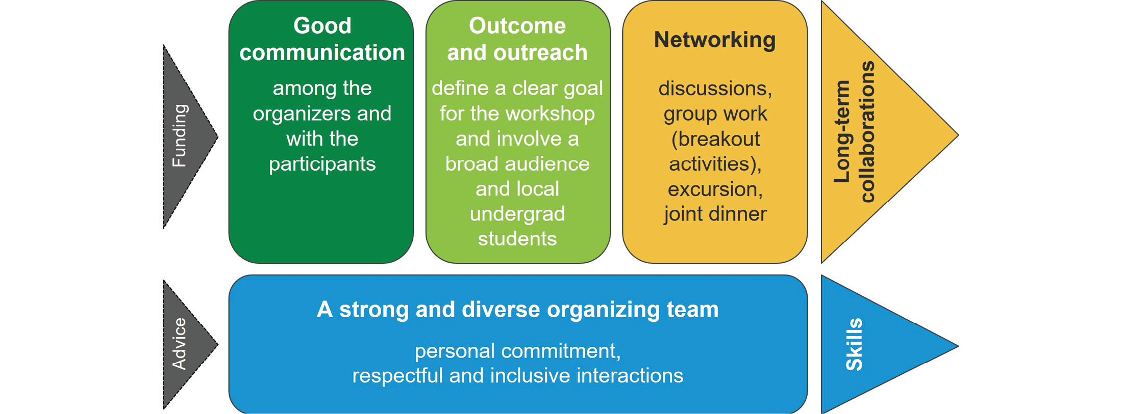
Figure 1: Schematic overview about important aspects needed to organize an ECR workshop. Note, ideally one gets more out of (triangles on the right) than one puts into (triangles on the left) an ECR workshop. |
5. Dedication
Event organization entails great personal commitment and is time consuming, e.g. frequent meetings over long time periods, selecting and keeping in contact with participants, and creating an interesting, meaningful, and diverse program.
6. Communication
Communication between organizers and with the participants is crucial. Here, frequent meetings with a written record on decisions made, and platforms for document sharing that can easily be accessed by everyone, are essential. Further, clear and timely communication about the workshop’s topic, target group, format, outcome, registration/application/selection procedures (e.g. definition of ECR), and deadlines is important.
7. Selection of participants
A system on how to rank applications in a balanced (including geographic and gender distribution), independent, and efficient way should be developed beforehand. Further, a structure in which each abstract is graded, based on criteria such as fit of topic, novelty, and research quality, can be helpful. Financial support is essential to facilitate participation of ECRs from low-income countries.
8. Networking
Interaction and networking are key elements of a workshop, and sufficient time should be allocated. Breakout activities are an established method to foster fruitful discussions. Here, it is important to communicate the goal clearly so that all participants know their role. Not only scientific, but also more general topics (e.g. "the challenges of being an ECR") provide a good basis for discussions. Other ways to combine knowledge growth and communication between participants, and create time to relax, are social gatherings and field excursions.
9. Involve locals
Involving local undergrad students will give them the chance to get closer insights into research, join a scientific community, take responsibility, and show engagement. They can be key for solving problems on site by overcoming language barriers. Further, cultural and scientific exchange with local students is an added value for both participants and organizers.
10. Outreach talks
Outreach talks can be organized to give a broad audience the chance to be involved in scientific activities. They are a good exercise for ECRs to present and receive feedback from people outside their research area.
11. Wrapping up, and the end?
At the end, certificates need to be handed out, finances consolidated, the event reported on, the results from breakout activities summarized, and then the workshop is over. But is it really over? Ideally, the established network becomes a base for long-term research collaborations, including the organization of further conference sessions or workshops.
affiliations
1Department of Biology, University of Southern Denmark, Odense, Denmark
2Faculty of Geography, Yunnan Normal University, Kunming, China
3CENAC-PNNH-CONICET, San Carlos de Bariloche, Argentina
4Department of Archaeology & Anthropology, University of Ibadan, Nigeria
5Department of Science and High Technology, University of Insubria, Como, Italy
6Department of Surface Waters - Research and Management, EAWAG, Dübendorf, Switzerland
7Department of Earth Science, ETH Zürich, Switzerland
8Institute for Modelling Socio-Environmental Transitions (IMSET), Bournemouth University, UK
9Department of History and Geography, University of Tarapacá, Arica, Chile
10School of Geography, University of Nottingham, UK
11Birbal Sahni Institute of Palaeosciences, Lucknow, India
12National University of Mar del Plata, Argentina
13Continental and Marine Waters Programme, Institute of Agrifood Technology and Research, IRTA, La Ràpita, Spain
Anna-Marie Klamt: amklamt outlook.de
In times of environmental crisis, effectively communicating scientific results to the wider public is of paramount importance (Fischhoff and Scheufele 2014). The ability of early-career researchers (ECRs) to make research accessible to different interest groups can increase opportunities for career development (Wright and Vanderford 2017).
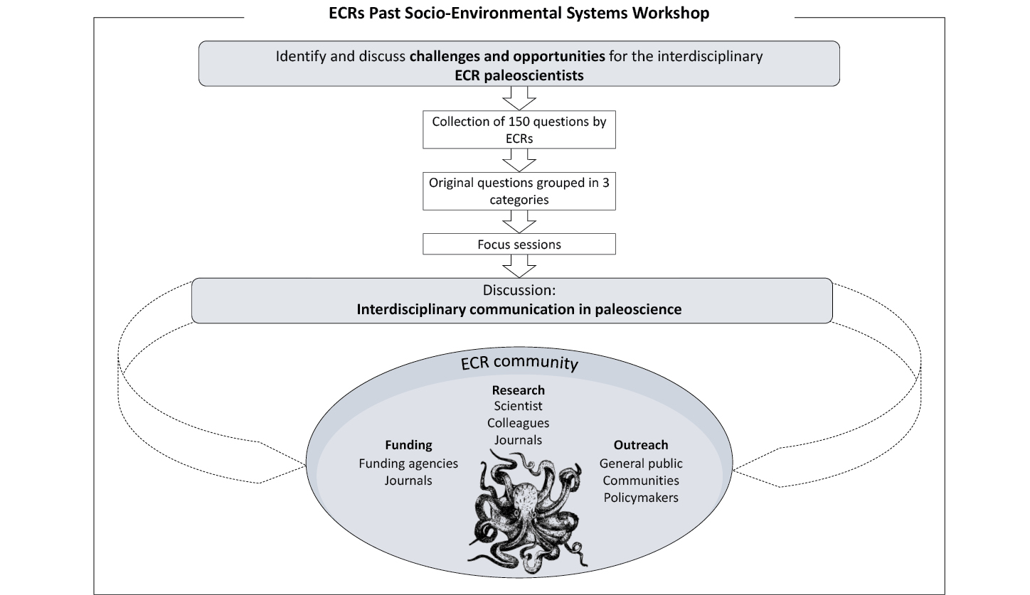
Challenges and opportunities of communication are amplified in interdisciplinary projects, such as those addressing past socio–environmental systems (PASES) (Benito et al. 2021). Here, we compare experiences among participants of the PAGES-INQUA ECR PASES workshop, to address the overarching question: does an ECR need to be an octopus to communicate interdisciplinary paleoscience? To answer this question, we focused on three topics: research, funding, and outreach (Fig. 1).
 |
|
Figure 1: Methodological framework and discussion outcomes (symbol attribution CC0 1.0 svgsilh.com/image/1296937.html) |
Research
Paleoscience spans a wide range of different domains, and scholars often work interdisciplinarily. Publishing pressure is particularly high for ECRs (van Dijk et al. 2014). Working interdisciplinarily requires additional time investments to keep up with new literature, while the few interdisciplinary journals available challenge research sharing, and can hinder career advancement.
Communication in research is key for the success of interdisciplinary projects. However, researchers working interdisciplinarily have to overcome semantic differences encountered in the specialized language of each domain. In this context, it can be challenging to communicate interdisciplinarily at field-specific conferences, but workshops organized by ECRs for ECRs (see the workshop report by Benito et al. on p. 48 of this issue) can be a perfect setting to exchange ideas and set the initial stage to develop collaborative projects.
Funding
ECRs are caught in a loop between funding agencies and journals, where successful grant applications depend on the quality of publications, which in turn require funding to produce data. Stakes are high for ECRs who are usually under non-permanent contracts. Proposal writing challenges are common across fields, requiring an equilibrium between details and the broader picture. Interdisciplinary proposals should highlight how each discipline is crucial to answering the research questions and demonstrate the impact of research on broader issues.
Although interdisciplinary proposals allow researchers to access funding schemes that are not available to single-discipline research projects, ECRs working in low- and middle-income countries, where institutions might lack grant advice offices, can face difficulties in accessing funding schemes (e.g. ERC grants). Being part of an ECR network (e.g. PAGES Early-Career Network) can be an advantage, as members can share information and experiences, and sometimes online resources are available (e.g. webinars, see PAGES ECN YouTube channel: youtube.com/PAGESECN).
Outreach
Communication to the public is a transferable skill increasingly valued by institutes, funding agencies, and journals. Plain language abstracts in scientific journals exemplify the different communication styles required to engage with a broader audience: scientifically accurate without excessive technical detail. Storytelling helps to raise interest in complex research topics, but it is not something scientists are trained for.
Paleoscience can deal with strong barriers in outreach (e.g. climate-change deniers), but topics related to PASES can be less challenging to communicate compared to other interdisciplinary topics. They can capture the attention of the audience by highlighting how paleoscientific research connects with pressing environmental issues (Razanatsoa et al. 2017). Furthermore, most ECRs might be at ease sharing their findings on social media platforms. Nevertheless, it may become overwhelming to keep up with different social media platforms. The ECR community can help, e.g. sharing publication posts to specific working networks that reach a larger audience (e.g. @PAGES_ECN).
Conclusions and recommendations
In the three domains of science communication that concern ECRs working on interdisciplinary subjects, challenges outnumber opportunities.
Our discussion is not new to ECRs in paleoscience (e.g. Plumpton et al. 2017, Roop and Dietze 2013) and is not meant to provide solutions. We highlighted aspects that emerged during our focus session, realizing that despite our different backgrounds, we shared common challenges.
Pressure on ECRs is high, mental health is at stake, work-life balance is often precarious, and time is limited. It is not required to master each of these communication aspects, but rather acknowledge their existence and focus on the opportunities. ECRs do not have to be octopuses; they can rely on a community to complement each other.
affiliations
1Department of Earth Science, ETH Zürich, Switzerland2Department of Surface Waters, Research & Management, Eawag, Dübendorf, Switzerland
3Institute of Archaeological Sciences (IAW), University of Bern, Switzerland
4Department of History and Geography, University of Tarapacá, Arica, Chile
5Faculty of Archaeology, Leiden University, Netherlands
6Climate Change Ecology Research Unit, Adam Mickiewicz University, Poznań, Poland
7Ecology Department, Pontificia Universidad Católica de Chile, Santiago, Chile
contact
Giorgia Camperio: show mail address
REFERENCES
Benito X et al. (2021) PAGES Mag 29(1): 58
Fischhoff B, Scheufele DA (2014) Proc Natl Acad Sci 111: 13583-13584
Plumpton H et al. (2017) PAGES Mag 25(2): 100
Razanatsoa E et al. (2017) PAGES Mag 25(2): 105
Roop H, Dietze E (2013) PAGES Mag 21(2): 95
Bolivian engineer Mónica Vicente visited the dendrochronology laboratory at IANIGLA-CONICET in Mendoza , Argentina, as part of the PAGES-IAI International Mobility Research Fellowship Program. During her stay from March to May 2022 she worked with tree rings and performed growth measurements in relation to the climate of the sampling zone.
Bolivia has the largest proportion of tropical dry forests in South America. However, there is strong pressure on forest areas due to anthropogenic activity. The highest deforestation rates are concentrated in the lowlands where most of the tropical dry forests are located. Therefore, it is essential to use paleoproxies to understand climatic variation over the last centuries in this region.
Dendrochronology is one of the most common tools used to generate information and reconstruct past climatic variations. In this sense, tree-growth rings, besides providing paleoclimate information, also allow us to understand the growth ecology of new species of great value, such as Platymiscium ulei.
The objective of this project was to study the potential of P. ulei in dendrochronology in tropical dry forests of Bolivia. Samples of P. ulei were taken in the Mercedes Forest management area, in the municipality of Concepción, department of Santa Cruz, Bolivia. The area has a mean annual temperature of 25.4°C and 1150 mm of annual precipitation with marked seasonal droughts throughout the year.
After cross-sections, samples of tree trunks were processed, and the growth rings were dated and measured following standard methods in dendrochronology. The manual dating was performed with the COFECHA program to verify the individual quality of each measurement by detecting and correcting possible dating errors (Holmes 1983). Thereafter, all the samples were standardized with the ARSTAN program (Cook and Holmes 1999).
Chronology
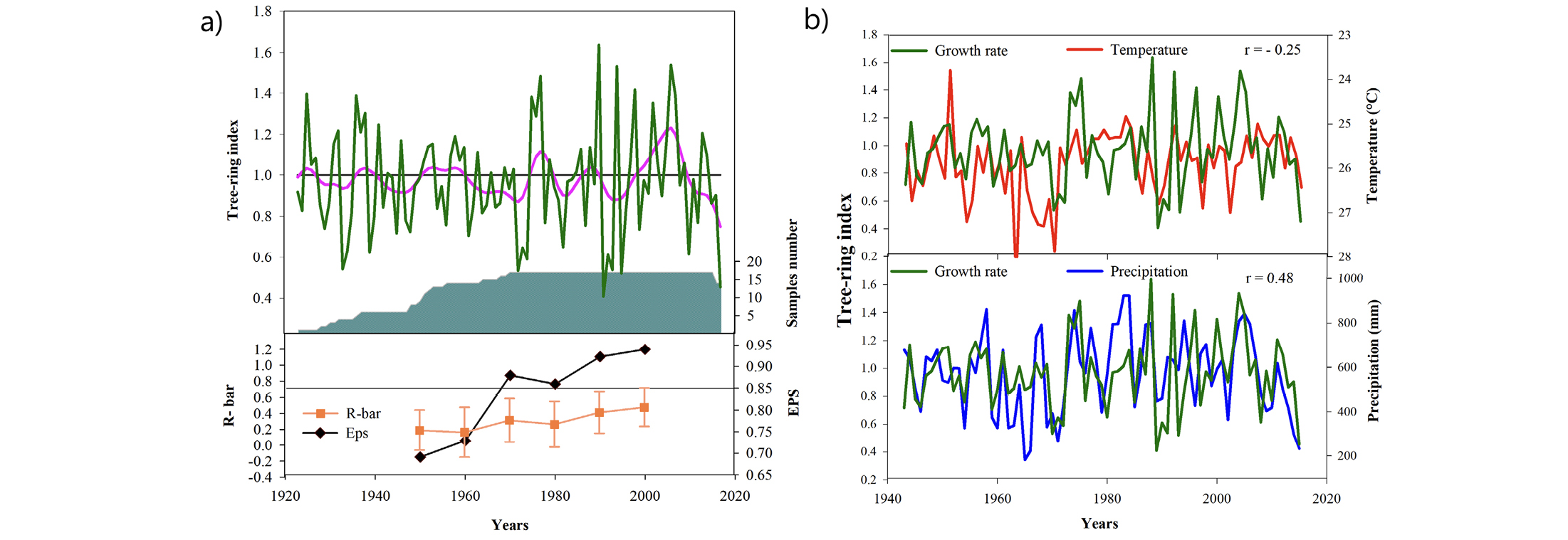
The tree-ring chronology corresponds to the period 1923–2015 CE (17 samples). The chronology is replicated by more than 10 trees from 1950 CE, and in 65 years has an autocorrelation of 0.50 indicating a common sign of growth and a mean sensitivity of 0.41, indicating the interannual variability in the width of the rings. Likewise, the chronology has an R-bar (running series of average correlations) of 0.30, which indicates the common growth signal over a period of time, and an EPS (expressed population signal) of 0.85 (Fig. 1a).
 |
|
Figure 1: (A) Standard chronology (top) 1923–2015 CE and number of P. ulei trees analyzed (middle). Statistics assessing the quality of the chronology using the values of EPS and R-bar over time (bottom). (B) Comparison between tree-ring growth rate and interannual variations of temperature (top) and precipitation (bottom) for the period 1943–2015 CE. |
EPS is an indicator of the population signal between a given chronology and a hypothetical chronology that has been replicated infinitely for a common time interval, and increases with more trees being incorporated (Wigley et al. 1984). Theoretically, EPS values equal to or greater than 0.85 indicate that the number of samples in the timeline is adequate, and capture an adequate percentage of the signal (Briffa 1999).
Climate-growth relationship
The tree-ring chronology starts at 1923 CE and climatological data are only available from 1943 CE onwards. The correlation of growth of P. ulei trees with precipitation during the wet season (October–March) is positive (r= 0.48; p<0.005) from 1943–2015 CE (Fig. 1b). The mean annual temperature for the same period has an inverse, but significant, correlation with growth rate (r=-0.25; p<0.005). The latter is explained by the higher temperatures that increase evapotranspiration, intensifying water deficit, and reducing radial growth (López and Villalba 2016).
The presence of growth rings in trees with annual periodicity is imperative for dendrochronological studies in tropical regions. In this sense, P. ulei trees in the Mercedes Forest present distinguishable rings with a similar growth pattern. Therefore, dendrochronological analysis can contribute to a better understanding of regional climate variability and its impact on the fragile ecosystems from which this species originates. The trees of this species capture a significant variation in the dominant climatic conditions of the area, which constitutes a premise for studies with dendroclimatic applications and, in turn, answers paleoclimatological and paleoecological questions prioritized by the paleoscientific community.
affiliation
Faculty of Agricultural Sciences, Gabriel René Moreno Autonomous University, Santa Cruz de la Sierra, Boliviacontact
Mónica Vicente: show mail address
references
Briffa KR (1999) In: von Storch H, Navarra, A (Eds) Analysis of Climate Variability. Springer, 77-94
Holmes RL (1983) Tree-Ring Bull 43: 69-78
López L, Villalba R (2016) Dendrochronologia 40: 85-92
Wigley TML et al. (1984) J Appl Meteorol Climatol 23: 201-213
Dr. Szejner was granted a PAGES–IAI Fellowship and worked at the Universidad Autónoma de México from July to August 2022. His goal was to establish and strengthen a collaborative network between tree-ring research groups from México and Chile, and to analyze stable isotopes in tree rings.
The fog-dependent forest on the southern edge of the Atacama Desert is one of the most fantastic and enigmatic woodlands one will ever see. This ecosystem is formed by patches of temperate rainforest located within a semiarid matrix at the southern edge of the Atacama Desert.
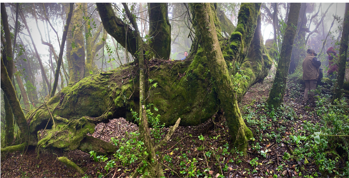
The Fray Jorge National Park is at the top of the coastal mountain range, facing the Pacific Ocean. These forests are relict formations from a past continuous distribution in the Pleistocene (Villagrán et al. 2004). This unique biogeographical landmark has been preserved due to exceptional orographic conditions, allowing for fog formation from the clouds from the Pacific Ocean. The fog is collected by an intricate vegetation structure consisting of the crowns of trees, vines, lianas, ferns, mosses, and fungi (Fig. 1). The condensed and trapped water drops into the soil, allowing the forest to thrive for millennia.
 |
|
Figure 1: Fog-dependent forests at the southern edge of the Atacama Desert in the Fray Jorge National Park. This olivillo tree (Aextoxicon punctatum) has been growing for hundreds of years, falling, sprawling, and re-rooting several times along the way, producing several trunks. |
Trees often reach more than one meter in diameter and can be as old as 250 years (Gutiérrez et al. 2008). These forests experience natural changes as part of their inherent development processes, with constant canopy gap formation contributing to their unique structure and composition (del-Val et al. 2006; Gutiérrez et al. 2008). There are two central species dominating this enigmatic forest: the most abundant, olivillo (Aextoxicon punctatum), followed by canelo (Drimys winteri). These are two dominant species from the evergreen temperate rainforests typically found around 1000 km south of this site.
Thanks to the support from this fellowship, we investigated how the ongoing regional megadrought (MD) in Central Chile (Garreaud et al. 2020) affects the Fray Jorge forests. This interest arises from the generalized concern in the region about the environmental, social, and economic impact of the current drought occurring in Central Chile, which is seen as a forecast of the climatic conditions that will prevail under current climate change scenarios (Cook et al. 2022; Garreaud et al. 2020). Increasingly, dry conditions and rising temperatures threaten forested ecosystems. Therefore, we need a better understanding of how trees respond to the recent regional aridity trends and the local oceanic fog dynamics.
Our objective in this study was to address questions on the effects of the current MD on fog variability and water availability on the forest response in this unique fog-dependent ecosystem. For this, we used conventional tree-ring techniques and stable isotopes (Belmecheri et al. 2022). We conducted our fieldwork in July 2022. We collected tree-ring samples of olivillo to generate new long-term records of tree-ring width chronologies, along with their oxygen (δ18O) and carbon (δ13C) isotopes.
In addition, we organized a workshop at Universidad Austral de Chile to discuss the applications and best practices for interpreting stable isotopes in tree rings. We also organized a series of lectures at the Fray Jorge National Park (La Serena, Chile) for the park rangers and staff to share some past findings, aiming to increase awareness about the effects of climate change on this unique ecosystem.
The outcomes of this fellowship will provide insights into the impact of the current MD on these forests, and reconstruct the tree responses of these unique forests in Chile. This effort will help to interpret changes in intrinsic water-use efficiency, vapor-pressure deficit changes, and potential changes in water sources that these fog-dependent forests have been experiencing over the last few decades. Additionally, our collaborative project will strengthen the academic relationship between Mexican and Chilean research centers and universities, promoting studies about climate change and its effects on the biogeochemical cycles recorded in the stable isotopes fixed in wood for centuries. Finally, this project will help initiate a Pan-American research program of stable isotope analyses in tree rings across Latin America.
ACKNOWLEDGEMENTS
PAGES-IAI International Mobility Research Fellowship Program for Latin American and Caribbean early-career scientists on past global changes. FONDECYT N°1201411, FONDAP-ANID 1522A0001. UNAM-PAPIIT IA201621. Grant ANID PIA/BASAL FB210006.
affiliations
1Instituto de Geología, Universidad Nacional Autónoma de México, Mexico City, México2Bioeconomy and Environment Unit, Natural Resources Institute Finland, Helsinki, Finland
3Laboratorio de Dendrocronología y Cambio Global, Instituto de Conservación Biodiversidad y Territorio, Universidad Austral de Chile, Valdivia, Chile
4Center for Climate and Resilience Research (CR) 2, Santiago, Chile
5Departamento de Ciencias Ambientales y Recursos Naturales Renovables, Universidad de Chile, Santiago, Chile
6Instituto de Ecología y Biodiversidad, Santiago, Chile.
contact
Paul Szejner: show mail address
references
Cook BI et al. (2022) Nat Rev Earth Environ 3: 741-757
del-Val E et al. (2006) Ecosystems 9: 598-608
Garreaud RD et al. (2020) Int J Climatol 40: 421-439
Collaboration between Dr. Echeverría and Dr. Moguel was carried out with the support of the PAGES-IAI International Mobility Research Fellowship Program during August and September 2022. This project allowed Dr. Echeverría to explore new insights into ancient DNA (aDNA) and sedimentary DNA (sedaDNA) analysis, supervised by Dr. Moguel, who has extensive experience in exploring sedaDNA and working in metagenomic studies at UNAM-Juriquilla, México.
Overall process
Paleoecological studies in Latin America provide information about changes in vegetation and climate during the late Quaternary. Analysis of aDNA is a field that is rapidly expanding as a new technique to reconstruct past and modern environments (Capo et al. 2021; Parducci et al. 2018).
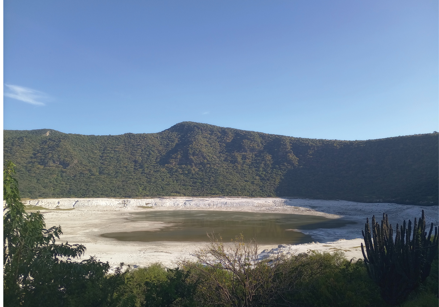
Rincón de Parangueo is a crater lake located in the Valle de Santiago volcanic field, central México (Fig. 1). The water level increases during the rainy season and it greatly reduces during the dry season, making this area an example of a fast and drastic transformation environment. Also, Rincón de Parangueo consists of native vegetation and constitutes one of the few natural areas of deciduous tropical forest in central México.
 |
|
Figure 1: Rincón de Parangueo crater lake has been exposed to exploitation as a hydric resource by residents of the region over the last 40 years, leading to a gradual drying of the lake. |
In this context, this site represents an ideal setting to study the microbiota biodiversity in the area through sedaDNA metagenomic analysis, and to reconstruct past environmental changes. We recovered a 964-cm-long sequence using a Livingstone corer from the Rincón de Parangueo lake. During the fieldwork, emphasis was placed on minimizing sample contamination, because it is critical for performing adequate DNA extraction and analysis. DNA samples were processed in the International Laboratory for Human Genome Research (LIIGH-UNAM-Juriquilla, México). DNA was extracted from 0.25 g sediment samples using the PowerSoil® DNA Isolation kit from QIAGEN, following the manufacturer’s protocol. An additional Proteinase K solution (400 μL, 2 mg/mL) per sample was added to complement the lysis process following Epp et al. (2019) modification protocol.
After the DNA extraction was made, the samples were purified using OneStep™ PCR Inhibitor Removal Kit to remove impurities from the samples. For the construction of the genomic libraries we used the NEBNext DNA Library Prep Master Mix Set (New England BioLabs) following the manufacturer’s protocol. DNA quantity was estimated using Qubit fluorometric equipment. After the genomic libraries construction, a qPCR was performed. The data obtained from the DNA extraction and metagenomic analysis from the Rincón de Parangueo sediment core will compliment the sedimentological and geochemical information available for this area, and, therefore, will allow us to carry out a more accurate environmental reconstruction, in terms of regional climate change.
Furthermore, Dr. Echeverría gave a seminar at CGEO-UNAM to talk about the collaboration with Dr. Moguel, and to discuss possible future project initiatives involving sedaDNA in Latin America. After this, there was an opportunity to discuss the outline of a whitepaper on South American sedaDNA paleoecology and future projects on the same topic. In particular, this future cooperation will focus on performing sedaDNA analysis to determine the times of colonization and expansion of the south Patagonia Argentina forest after the deglaciation. These results will be combined and interpreted together with pollen records made by Dr. Echeverría. These data will help to determine which tree species were the first ones to expand after the glacial retreat, and also if some of these species may have survived in refugia during cold stages.
Conclusion
The PAGES-IAI Fellowship was a unique opportunity to establish an international sedaDNA network between Latin American countries, promoting new sedaDNA projects between México and Argentina. Also, the PAGES-IAI Fellowship enabled the planning of a joint future project in Patagonia, Argentina, where the sedaDNA analysis will play a key role.
Today, Latin American researchers are still largely underrepresented in the sedaDNA research community. For this reason, the PAGES-IAI International Mobility Research Fellowship Program represented a great opportunity to increase the number of sedaDNA projects in Latin America and to empower local researchers to play a central role in lake sedaDNA research in the near future.
affiliations
1Instituto de Investigaciones Marinas y Costeras, Universidad Nacional de Mar del Plata, Argentina2Centro de Geociencias Center, Universidad Autónoma de México - Campus Juriquilla, México
3Laboratorio Internacional de Investigación sobre el Genoma Humano, Universidad Autónoma de México - Campus Juriquilla, Mxico
contact
Marcos E. Echeverría: show mail address
references
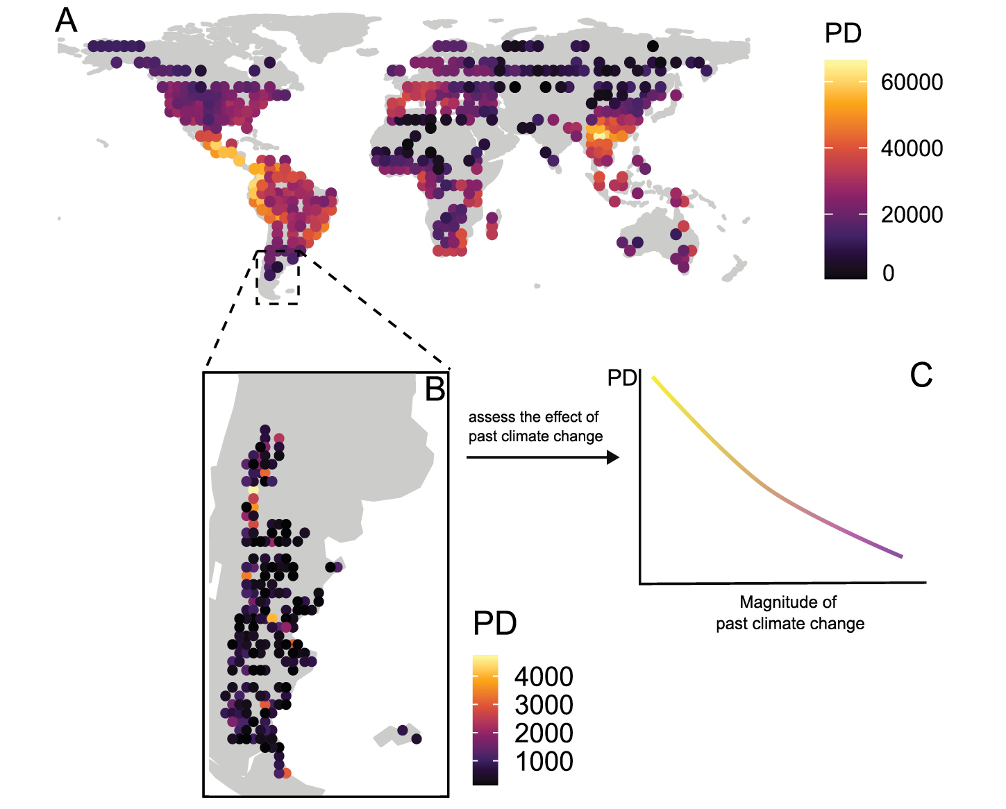
Dr. Matias C. Baranzelli from Argentina, travelled to the Universidad Nacional Autónoma de Mexico as a PAGES-IAI International Mobility Research Fellow, from 18 May–19 August 2022. He studied the response to climate change over the last three million years on flowering plants, mammals, birds and amphibians, considering three levels of biodiversity: genetic diversity, species richness, and phylogenetic diversity. This is an integrating and novel approach to decipher the role of past climate change on current patterns of biodiversity.
Understanding how paleoclimatic changes have shaped global biodiversity has long been a challenge for biogeographers. In recent years, this has become an urgent goal to improve our ability to predict biodiversity response to global change. Uncovering the relationships between biodiversity and past climate change can provide testable hypotheses about the current and future impacts of ongoing anthropogenic climate change on biodiversity distribution. The impact of different anthropogenic activities on ecosystems is the main cause of the biodiversity crisis (Urban 2015); hence, there is a need for conservation biology to combine taxonomic, evolutionary, and phylogenetic research with ecological research (Eguiarte et al. 1999). In particular, phylogenetic diversity (PD) emerges as a fundamental conservation tool that combines information on species richness and phylogenetic relationships for any given region. In essence, PD is the total branch length of a phylogenetic tree that connects all species in a given group (Faith 1992). An ensemble with more distantly related species will be phylogenetically more diverse than one with species more closely related.
Different aspects of biodiversity are integrated into the PD and provide clues about ecosystem responses to climate change. Species that share a common evolutionary history are expected to have specific ecological traits that may enable them to persist, either in areas with historical climatic instability, or in areas with stable climates (Santos et al. 2022). In either case, species distributions may be significantly altered with each climate cycle, resulting in distribution patterns that are consistent with ecological features and shared phylogenetic signals (Santos et al. 2022). For example, communities within areas that underwent profound past climate change will tend to show species that are more phylogenetically clustered; that is, communities composed of more closely related species than expected by chance. Given this expectation, determining the relationship between phylogenetic diversity and past climate change can prove key to understanding how communities might respond to ongoing climate change. This can help identify priority regions for conservation.
 |
|
Figure 1: Estimation of global (A) and regional (Patagonian Steppe) (B) phylogenetic diversity (PD) from phylogenetic data and georeferenced records of angiosperm species. Future studies will evaluate PD relationships with past climate change (C). |
During the PAGES-Inter American Institute for Global Change Research Fellowship at the UNAM, we estimated the phylogenetic diversity of flowering plants across the globe (Fig. 1a) and across the Patagonian Steppe in South America (Fig. 1b). For this, we used geographic data from Ramírez-Barahona et al. (2020) and Baranzelli et al. (2022), and combined them with the phylogenetic tree developed by Smith and Brown (2018). Our main goal was to evaluate the relationship between phylogenetic diversity and past climate change at different temporal and spatial scales (Fig. 1c). We also estimated phylogenetic diversity for three groups of terrestrial vertebrates across the globe (mammals, birds, and amphibians). The main results of this study were reported at the VII Mexican Congress of Ecology, which took place over the course of the PAGES-IAI Fellowship.
The experience at the UNAM also served to create new research collaboration experiences between different Latin American institutions to evaluate the role of past climate change on biodiversity. By combining the bioinformatic and conceptual capabilities of host and home institutions, it is expected that relevant models will be obtained to understand the effect of past climate change on current patterns of global biodiversity, considering all its dimensions (i.e. genetic diversity, species richness and phylogenetic diversity). We expect to submit the main results to a peer-reviewed journal in the following months.
affiliations
1Laboratorio de Ecología Evolutiva - Biología Floral, Instituto Multidisciplinario de Biología Vegetal (IMBIV), CONICET-Universidad Nacional de Córdoba, Argentina2Departamento de Botánica, Instituto de Biología, Universidad Nacional Autónoma de México, México
contact
Matias C. Baranzelli: show mail address
references
Baranzelli MC et al. (2022) Biol Conserv 268: 109492
Eguiarte LE et al. (1999) Rev Chil Hist Nat 72: 475-492
Faith DP (1992) Cladistics 8: 361-373
Ramírez-Barahona SA et al. (2020) Nat Ecol Evol 4: 1232-1238
Santos AMC et al. (2020) Glob Ecol Biogeogr 29: 1758-1769
Christine Omuombo![]() 1,2,3
1,2,3
 |
 |
As a PAGES-Inter-Africa Mobility Research Fellow, Dr. Christine Omuombo undertook training, a laboratory exchange and research networking at the University of Cape Town’s Stable Light Isotope Laboratory.
Most of the paleoclimatic reconstructions from East Africa have been obtained from lacustrine and swamp records. These records reveal the effects of long-term climate change and local tectonics linked to the development of the East African Rift System, and the sensitivity to changes in the African monsoonal rainfall belt that migrates with the Intertropical Convergence Zone (ITCZ; Nicholson 1996). These records of past changes have shown the variability in the amount of precipitation over nearly constant temperatures (Bonnefille et al. 1991).
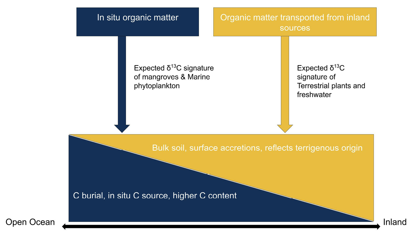
Along the coastal zone, few records exist of the paleoclimatic response of ecosystems. The mangrove forest is one of the most important ecosystems along the Kenyan coast, covering 60% in the Lamu Archipelago within the tidal and intertidal zones (Fig. 1). The sediments in these zones are usually either in-situ, or transported from inland catchments by the Tana river, and distributed along the coast by longshore sediment transport.
 |
|
Figure 1: Conceptual diagram of organic matter from the intertidal zone. The yellow color corresponds to terrestrial/inland origin of organic carbon, while the blue color represents in-situ produced organic carbon. |
The intertidal zone and organic carbon in the Lamu Archipelago
The intertidal zone is sensitive to global carbon cycle processes driven by sea-level changes. The Lamu Archipelago, a group of low-lying islands with wide intertidal platforms, comprises the old deltaic plains of the Tana River that developed after the last glacial sea-level lowering and subsequent post glacial Holocene flooding of continental shelf and coastal valleys, isolating the island from the delta system (Accordi and Carbone 2016). The aim of the PAGES-Inter-Africa Mobility Fellowship was to carry out the analysis of δ13C and δ15N values, total organic carbon (TOC), and total organic nitrogen (TON) content and atomic C/N ratios at the Stable Light Isotope Laboratory at the Department of Archaeology, University of Cape Town, to provide a comprehensive paleoenvironment dataset from sediment samples from the Lamu Archipelago. In addition, the fellowship was also a networking opportunity with research teams at the University of Cape Town (Department of Geological Sciences, The African Climate and Development Initiative, and the Plant Conservation Unit), and with the Iziko Museum.
The relevance of sediment geochemistry on mangrove paleoecology
The relative sea-level rise variation of the coastal zone in East Africa during the Late Holocene is not well understood. Several attempts have been made to reconstruct Holocene sea-level changes from the relationships between key mangrove taxa along the Tanzanian coast (Punwong et al. 2018), which have shown its utility in estimating low and high magnitude rise during the entire period. Sediments in the intertidal zones, where mangrove forests are found, are carbon sinks currently being studied to help mitigate the effects of climate change, even though the sediment dynamics are not well understood.
The geochemical analyses at the Stable Light Isotope Laboratory
A total of 50 samples from a sediment core and surface sediments were obtained in the Lamu Archipelago, with the aim of determining coherency of the paleoecological and fluvial dynamics of the coastal zone, and the broad climatic changes. At the beginning of the stay, a laboratory protocol was developed specifically for the sediment samples which are not common at the facility, enabling the preparation of the samples for analysis. This step was followed by training on instrument calibration, sample analysis, and quality control. The energy crisis in South Africa, with frequent rolling blackouts, affected the efficiency and accomplishments of the laboratory analyses. The support from colleagues in the laboratory was very commendable in learning new ways of working and efficiency.
Currently, it is estimated that the analysis of the samples will take another five to eight weeks after the end of the fellowship. These results will be part of a manuscript on the past vegetation changes linked to climatic and sea-level fluctuations, erosion, and changes in anthropogenic land use during the Late Holocene along the Kenyan Coast. Plans are underway to develop joint proposals for future exchanges and partnerships, and to present findings at the East Africa and South Africa Quaternary Associations meeting, and other conferences.
affiliations
1Department of Geoscience and Environment, Technical University of Kenya, Nairobi, Kenya2Institute for Climate Change and Adaptation, University of Nairobi, Kenya
3Department of Earth Sciences, National Museums of Kenya, Nairobi, Kenya
contact
Christine Omuombo: show mail address
references
Accordi GE, Carbone F (2016) J Afr Earth Sci 123: 234-257
Bonnefille R et al. (1991) Rev Palaeobot Palynol 67: 315-330
PAGES Inter-Africa Mobility Research Fellow, Dr. Abraham Dabengwa, was hosted by Dr. Jemma Finch for one week at the University of KwaZulu-Natal, South Africa. From 29 August–2 September 2022, he explored digital analysis of sedimentary charcoal, discussed challenges around African paleofire research, and broadened his scientific network.
Fire is a global driver of vegetation dynamics and biodiversity, and a key regulator of terrestrial carbon stocks. Forested biomes storing extensive aboveground carbon reserves are threatened by increasing fire activity from global warming and rainfall deficits (Pechony and Shindell 2010). Meanwhile, in tropical savanna and grassland biomes (i.e., tropical grassy biomes) where fire is considered endemic (Dabengwa et al. 2022), evidence shows declining fire activity. Ironically, global climate and biodiversity management policies still treat biomes with trees indiscriminately, often ignoring diverse fire histories. Publicly available global fire data is mainly derived from airborne imaging sensors developed in the last 70–80 years. However, this short timescale limits analysis of nuanced social, ecological, and climate changes shaping grassy biomes. This is where the quantification of charcoal fragments from sedimentary deposits could extend temporal fire reconstructions.
Charcoal fragments from depositional environments give clues about past fire behavior and patterns. For example, charcoal amounts are used to infer burned area, fire prevalence, and fire intensity (Duffin et al. 2008); charcoal-size abundance distributions indicate fuel flammability gradients and transitions among alternative vegetation states (Dabengwa et al. 2022); and charcoal shape factors represent fuel characteristics (Umbanhowar and McGrath 1998). Digital image analysis has advanced the analysis of shape factors linked to coarse-woody versus fine-grassy fuels (Aleman et al. 2013), with data produced at high spatial and temporal resolution. Shape factors including elongation ratios have been studied for charcoal produced by various plants (Umbanhowar and McGrath 1998). However, shape factors are considered unchanged from charcoal production to accumulation in sediments, and after sample processing.
To test the assumption of stationary shape factors in fuel attribution, we compared samples from African grassy biomes with frequent fire, fragmented fuel-beds, local presence of woody graminoids like reeds, and trampling by large herbivores. We had the following objectives:
• Design a study to conduct reproducible sedimentary charcoal image analysis;
• Build local capacity in charcoal image analysis by training junior research assistants; and
• Test the sensitivity of charcoal shape factors at sites with contrasting fire and grazing disturbance histories, sample preparation methods, and by different analysts.
Methods
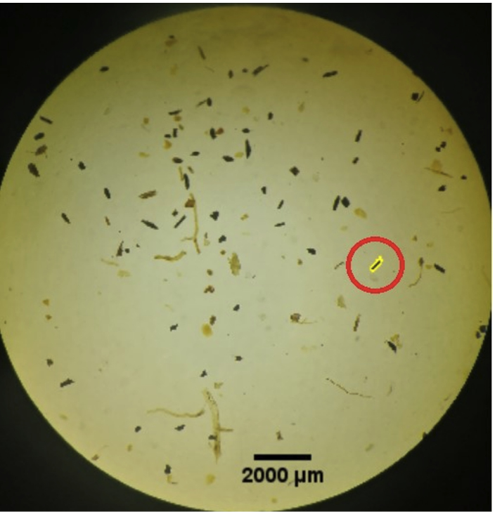
We analyzed ~150 archival sedimentary macro-charcoal samples (i.e. recovered from sieves ≥ 150 µm) from three South African grassy ecosystems, together with modern samples prepared using different paleoecological methods. Sites varied in vegetation type and disturbance history. The macro charcoal had been recovered from the standard swirling pollen (Finch and Marchant 2011) and phytolith preparation methods. Retained macro-charcoal samples from different preparation methods and sites with counts visually estimated using the petri dish method were sorted in ascending order. Rank-ordered samples were divided between two research assistants (Enele Twala and Megan Govender). The researchers worked on samples with nearly matching prior macro-charcoal estimates. Samples were sub-sampled using a modified petri dish, (i.e. a 3x4 cell culture plate with 22 mm diameters) to increase the sampling area. Sub-samples were imaged using stereomicroscopes at x50 magnification. Supervised image analysis of charcoal fragments was done with an open-source, edge-detection algorithm, CharTool, in ImageJ (Fig. 1) (Snitker 2020). Samples were blind cross-validated by having researchers reanalyze samples from one another. A subset of validation dataset will be reanalyzed by a senior researcher to complete the cross-validation.
 |
|
Figure 1: Supervised analysis of charcoal using edge-detection from CharTool v1 macro in ImageJ. Users select a charcoal fragment, then the algorithm draws an outline around the fragment and calculates measurements (Image credit: Enele Twala). |
Outputs
This work is ongoing as we must analyze and interpret results. In addition, we will test a competing object-based image analysis (OBIA) for batch image analyses. The technique uses a segmentation approach similar to edge detection, and allows objects to be classified based on color, geometry, texture, and context. We will share project outputs and upcoming activities through the International Paleofire Network (paleofire.org), which posts regularly in the Past Global Changes Magazine and PAGES Newsletter, and on Twitter (@PaleofireWG). Upon completion, images and data from this project will be publicly available in the Neotoma Paleoecology Database (neotomadb.org).
affiliation
1Evolutionary Studies Institute, University of the Witwatersrand, Johannesburg, South Africa
2School of Animal, Plant and Environmental Sciences, Johannesburg, South Africa
3School of Agricultural, Earth and Environmental Sciences, University of KwaZulu-Natal, Durban, South Africa
contact
A.N. Dabengwa: show mail address
references
Aleman JC et al. (2013) Holocene 23: 1853-1862
Dabengwa AN et al. (2022) Afr J Range Forage Sci 39: 27-43
Duffin KI et al. (2008) Holocene 18: 279-291
Finch J, Marchant R (2011) Veg Hist Archaeobot 20: 109-124
Pechony O, Shindell DT (2010) Proc Natl Acad Sci U S A 107: 19167-19170
pSESYNTH project: Community mobilization for a multi-disciplinary paleo database of the Global South
How to enhance paleoscientific research, collaboration and application in the Global South? The INQUA-funded multi-year pSESYNTH project envisions the first multi-disciplinary Holocene paleo database through a collaborative vision for past human–environmental systems in the Global South, and their future sustainability.
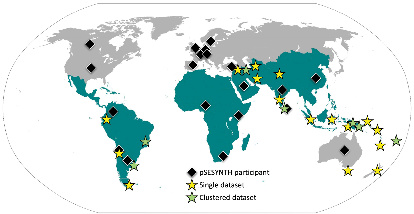
The value of, and theoretical basis for, interdisciplinary approaches in paleosciences has been widely recognized (e.g. Dearing et al. 2011; Fischer et al. 2021). Meanwhile, it has also been realized that identifying feasible and inclusive strategies to put interdisciplinarity into practice requires continued community mobilization and collaboration (Swanson et al. 2021). Here, we bring an example of scientific community mobilization and collaboration focused on the Global South; the geographical region covering Latin America and the Caribbean, Africa, Asia, and parts of Oceania (Fig. 1), where researchers have been historically, and often continue to be, marginalized from international collaborations (Maas et al. 2021).
 |
|
Figure 1: Map showing the regions of the Global South (in green), which is the geographical focus of pSESYNTH. Black diamonds show distribution of pSESYNTH participants from and/or working on the Global South. Yellow and green stars show the location and nature (single or clustered) of the datasets gathered so far. |
The study of past global changes and their interactions with socio–environmental systems is highly underrepresented in the Global South. Yet, its diverse landscapes, including tropical forests, high-latitude alpine areas and grasslands, coastal wetlands, as well as polar regions under climatic and anthropogenic pressures, urge for an unbiased understanding of human–environmental dynamics at different spatial and temporal scales.
Moreover, most, if not all, developing countries are part of the Global South, bringing an additional challenge in relation to ecosystem conservation, management, and exploitation of natural resources (Lebel and McLean 2018; Monsarrat and Svening 2021; Raja et al. 2022). Given the long histories of human occupation and the influence of past climates and land-use practices in shaping landscapes of the Global South, understanding the interactions among climate, human societies, and ecosystems is key to improving the knowledge of pressing environmental challenges.
pSESYNTH: genesis and objectives
Stemming from the PAGES-INQUA supported early-career researcher workshop on "Past Socio–Environmental Systems (PASES)" (pastglobalchanges.org/calendar/26972) in 2020, the INQUA-funded project "The whole is not the sum of the parts: building a synthesis database of past human–environmental systems in the Global South (pSESYNTH)" has initiated research collaborations among paleoscientists from, and/or working on, the Global South and other underrepresented regions of the world (e.g. Australia, Southeast Europe).
Pursuing the Integrated, Coordinated, Open, and Networked (ICON) approach (Koren et al. 2022), the overarching goal of pSESYNTH is to establish, articulate and strengthen regional, interdisciplinary teams for studying past socio–environmental systems of the Global South, and to build the first multi-disciplinary paleo database representing its regions.
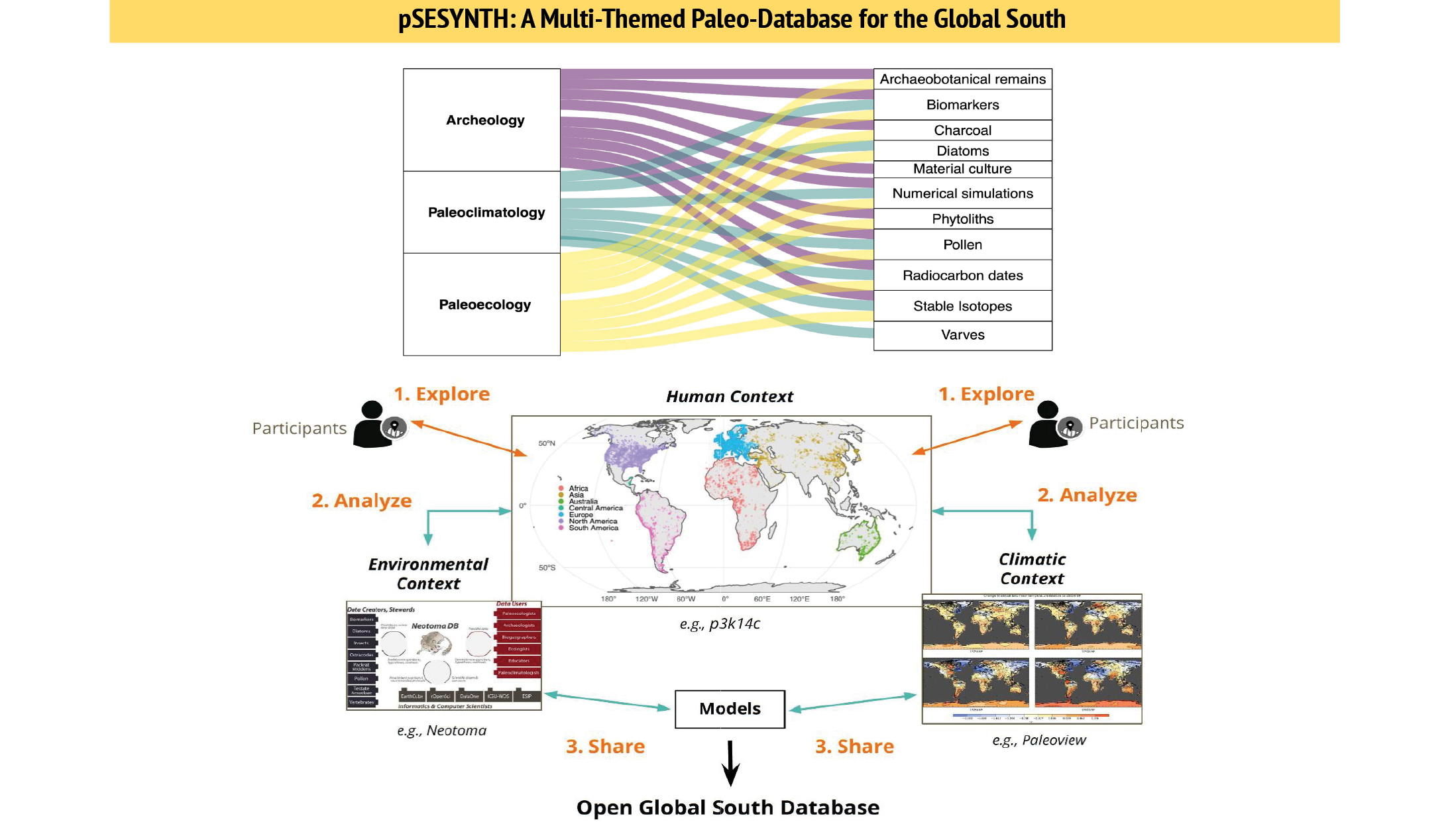
pSESYNTH primarily focuses on the Holocene (the last 11.7 kyr) because: (i) there is greater spatial availability and better chronological controls of the datasets compared to the Pleistocene, and (ii) the Holocene is characterized by a progressive degree of anthropogenic influence over landscapes, offering ways to explore the evolution of diverse socio–environmental systems. Under the pSESYNTH framework, linking proxies of environmental change with climatic signals and societal processes (e.g. subsistence strategies, growth rates, migrations) will provide baselines to pose and test multiple hypotheses for explaining the trajectories of socio–environmental systems. Specifically, pSESYNTH activities are being developed around three main objectives (Fig. 2):
 |
|
Figure 2: Schematic diagram showing pSESYNTH’s objectives (explore, analyze, and share) and the core themes (paleoecology, paleoclimatology, and archaeology) under exploration, driving the synthesis of ideas, as well as datasets, provided by the project’s participants and published databases. |
1) To explore drivers of past environmental change combining a diverse set of proxy information, organized into three themes: paleoecology (e.g. pollen, charcoal, diatoms), paleoclimatology (e.g. biomarkers, stable isotopes, varves, numerical simulations), and archaeology (e.g. radiocarbon dates, phytoliths, archaeobotanical remains, material culture).
2) To quantitatively analyze the links among paleoecology, paleoclimatology and archaeology, with an emphasis on research questions that can be generic across the Global South (e.g. are there connections, or commonalities, between colonial legacies and the evolution of socio–environmental systems in the Global South?) or specific to each subregion (e.g. at what spatial and temporal scales were human–environmental systems coupled or uncoupled to climatic fluctuations?).
3) To share the outputs and products of the project in the form of a database that meets the FAIR (Findable, Accessible, Interoperable and Reusable) principles (Wilkinson et al. 2016). pSESYNTH participants will capitalize on existing single- and multi-themed databases (e.g. Neotoma, NOAA, PANGAEA, p3k14c, ArchaeoGlobe) in complementing their data contributions in the novel Global South database. Together, the FAIR–ICON principles will underpin the database organization and will ensure geographic coverage, comparability, and accessibility for time-series data synthesis, which is crucial for mainstreaming paleoscience research from the Global South.
Paleoscientific synthesis: Early insights
Drawing upon the newly built Global South network (Fig. 1), the pSESYNTH project has been facilitating discussions on how varied datasets from different Global South regions can be effectively consolidated, and to achieve this goal, how critical it is to continue strengthening dialogues across the sub-disciplines of paleoscience. To this end, pSESYNTH has encouraged hands-on opportunities for developing three region-specific subgroups – the Americas, Asia-Africa, and Australasia-Oceania – that have been stimulating community-led research questions and syntheses of datasets at the intersection of climate, humans, and environment.
While there are multiple lines of inquiry (e.g. fire history, food production, extreme events, island colonization) that appeal to the respective subgroups, the topic of collective interest across the Global South is spotting changes in land-use patterns under pre- and post-colonial contexts. For example, in the case of the Americas, a preliminary exploration of pollen sites in the Neotoma database yielded 18 records, out of which 15 sites contain non-native pollen taxa such as Rumex and Plantago from 500 cal yr BP onwards, suggesting rapid and widespread European influence on the landscapes.
In the current pSESYNTH database, eight datasets contain lake sediment records from the Americas, yet they represent a small proportion of the >1300 cores available in the Latin American Pollen Database (latinamericapollendb.com) to unravel the complexities of colonization processes in the subregion (Flantua et al. 2015). Similarly, questions of when and how colonization altered island ecosystems has also been the focus of the data synthesis for the Australasia-Oceania subregion, where most of the database entries are high-resolution lacustrine pollen records. These records can be used to develop hypotheses on the role of colonial legacies in the evolution of socio–environmental systems in the Global South (e.g. Burney 1997).
Unlike the other two, the Asia-Africa subregion is visibly the most paleodata-poor subregion of the Global South (Fig. 1), currently lacking the spatial coverage and temporal resolution in identifying the impacts of colonialism. The available paleorecords from the Asia-Africa subregion, however, can help discern region-specific, perhaps continental scale, patterns for long-term vegetation change, land use, and landscape management, thereby complementing knowledge emerging from other subregions of the Global South.
Through as many as 64 records are integrated in the pSESYNTH database so far, the topics of common interest within and across the subregions find direct links to identifying historical baselines to constrain scenarios toward practical strategies for sustainable management of the Global South landscapes.
Future directions
The prime goal of pSESYNTH is to design a functional database structure, containing curated sets of interdisciplinary case studies from the Global South, aimed at providing reference data to foster collaborations among paleoscientists. The database produced as the final outcome of pSESYNTH will be publicly available online, and accessible via R shinyApp (Chang et al. 2022), which will work as a platform for visualizing the datasets, as well as for locating complementary datasets from other databases.
Raw data assigned with DOIs will be securely stored in a repository (e.g. Zenodo), ensuring ownership credits to the original contributors along with secured and transparent data reusability guidelines before the final products are released. In the upcoming years, pSESYNTH activities will continue to cross-fertilize knowledge and methods, utilizing the INQUA HABCOM support and upcoming PAGES–INQUA synergistic activities as platforms, all oriented towards enhancing paleoscientific research, collaboration and application in the Global South.
affiliations
1Independent researcher, Chennai, India
2Departamento de Ciencias Históricas y Geográficas, Universidad de Tarapacá, Arica, Chile
3Institute of Geosciences, Section of Meteorology, Rheinische Friedrich-Wilhelms-Universität Bonn, Germany
4Department of Archaeology and Heritage Studies, Ahmadu Bello University, Zaria-Nigeria
5Institute of Pre- and Protohistoric Archaeology, Kiel University, Germany
6Geoecology, Department of Environmental Sciences, University of Basel, Switzerland
7Laboratory of Analytical Chemistry, Paul Scherrer Institute, Villigen, Switzerland
8ARC Centre of Excellence for Australian Biodiversity and Heritage, College of Arts, Society and Education, James Cook University, Cairns, Australia
9Department of Earth Sciences, University of Toronto, Toronto, Canada
10Center for Water Infrastructure and Sustainable Energy (WISE) Futures, Nelson Mandela African Institution of Science and Technology, Tengeru, Arusha, Tanzania
11Institut für Geosysteme und Bioindikation. Technische Universität Braunschweig. Braunschweig, Germany
12Research Institute of Forests and Rangelands, Agricultural Research Education and Extension, Tehran, Iran
13Department of Archaeology and Ancient History, Uppsala University, and Department of Human Geography, Stockholm University, Sweden
14Centro Universitario Regional Este, Departamento de Geociencias, Udelar, Uruguay
15Programa de Pós Graduação em Oceanologia, Instituto Oceanográfico FURG, Brazil
16Department of Earth Science, Palynology and Paleobotany, National Museums of Kenya, Kenya
17Department of Geography, Man and Nature, Muséum National d'histoire Naturelle, France
18 Department of Geography, University of Lincoln, UK
19Australian Research Council Centre of Excellence in Australian Biodiversity and Heritage, The Australian National University, Canberra, Australia
20Universidade da Coruña, GRICA Group, Centro Interdisciplinar en Química e Bioloxía (CICA), Facultade de Ciencias, Coruña, Spain
21Key Laboratory of Marine Ecosystem Dynamics, Second Institute of Oceanography (SIO, MNR), Hangzhou, P.R. China
22Department of Archaeology, Max Planck Institute of Geoanthropology, Jena, Germany
23Palynology & Paleobotany Section, Earth Sciences Department, National Museums of Kenya, Nairobi, Kenya
24Copernicus Institute of Sustainable Development, Utrecht University, Utrecht, the Netherlands
25Department of Geography, Durham University, Durham, UK
26Centro de Investigación GAIA-Antártica (CIGA), Universidad de Magallanes, Chile
27Cape Horn International Center (CHIC), Universidad de Magallanes, Chile
28RISKNAT Research Group, Department of Earth and Ocean Dynamics, University of Barcelona, Barcelona, Spain
29Geoarchaeology Group, Deccan College Post Graduate Research Institute, India
30Department of Geography, Olabisi Onabanjo University Ago-Iwoye Nigeria
31Institute for Modelling Socio-Environmental Transitions, Department of Archaeology and Anthropology, Bournemouth University, UK
32Department of Earth Sciences, Indiana University-Purdue University, Indianapolis, USA
33Laboratorio de Paleoecología, Facultad de Ciencias, Universidad Nacional de Colombia-Sede Medellín, Colombia
34Baden-Württemberg State Office for Cultural Heritage (LAD)- Regierungspräsidium Stuttgart, Gaienhofen-Hemmenhofen, Germany
35Department of Applied Earth Sciences, Uva Wellassa University, Sri Lanka
36IPATEC-Centro Regional Universitario Bariloche (CRUB), CONICET-Universidad Nacional del Comahue, Argentina
37Archaeology, School of Humanities, University of Sydney, Australia
38Instituto de Investigaciones Marinas y Costeras (IIMyC)-Consejo Nacional de Investigaciones Científicas y Técnicas (CONICET), Universidad Nacional de Mar del Plata, Argentina
39Marine and Continental Waters Programme, Institute of Agrifood Technology and Research, IRTA, La Ràpita, Spain
contact
Charuta Kulkarni: ckulkarnigradcenter.cuny.edu
references
Burney DA (1997) Hum Ecol 25: 437-457
Chang W et al. (2022) shiny: Web Application Framework for R
Dearing J et al. (2011) PAGES Mag 19(2): 43
Fischer H et al. (2021) PAGES Mag 29(1): 7-9
Flantua SG et al. (2015) Rev Palaeobot Palyno 223: 104-115
Koren G et al. (2022) Earth Space Sci 9: e2022EA002231
Lebel J, McLean R (2018) Nature 559: 23-26
Maas B et al. (2021) Conserv Letters 14: e12797
Monsarrat S, Svening J-C (2021) Ecography 4: e06354
Raja N et al. (2022) Nat Eco Evo 6: 145-154
The local response of the environment to climate forcing in northeast India during the 4.2 ka event was coupled with human response to global changes in the natural environments. These sudden changes were coincidental to the decreased southwest monsoon strengths.
The 4.2 ka event
The response of the natural environment towards extreme climate events also has consequences for human societies. Abrupt climate change events, such as the 4.2 ka event, led to the global demise of several once-developed and flourishing human civilizations. In the eastern Himalayas, this was correlated with prolonged multi-decadal to multi-century droughts (Mehrotra et al. 2019).
There could have been natural forcing factors behind this sudden demise of populations observed in the Indus valley of ancient India, Egypt, and Mesopotamia around 4 kyr BP (Mehrotra et al. 2019). The forcing factors that led to this abrupt climate change event, coupled with human response, were sudden change in the monsoon pattern, fluctuation in solar radiation, and reduction in the sea-surface temperature (Berkelhammer et al. 2012; Bond et al. 2001; Dixit et al. 2014 and references therein; Hong et al. 2003; MacDonald 2011; Staubwasser et al. 2003).
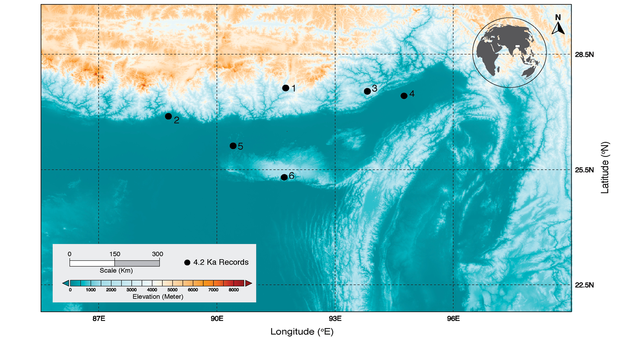
Proxy records of paleoclimatic change during the 4.2 ka event have been studied at a global scale (Mehrotra et al. 2019). A few multi-proxy records in high-altitude settings in northeast India also record marked cold and dry conditions, such as at the Ziro and Pankang Teng Tso (PTTso) lakes in the eastern Himalayas (Ghosh et al. 2014; Mehrotra et al. 2019), or at Darjeeling Himalaya (mountain range in the foothills of the eastern Himalayas) (Gosh et al. 2015). In other locations, such as Lower Subansari and Assam, a reduction in monsoon strength was observed during the same period (Fig. 1) (Bera and Basumatary 2013; Tripathi et al. 2019).
Fluvial and lacustrine sediment records
The climate fluctuations during the mid-Holocene, and prevailing cold-dry conditions around 4.2 kyr BP, were observed in palynological, carbon isotope and paleomagnetic records from sediments at the catchment of PTTso Lake (Mehrotra et al. 2019) (Fig. 1: Site 1). The palynological and carbon isotope evidence from the sediments of the Neora and Murti river beds in the Jalpaiguri district of Darjeeling Himalaya (Fig. 1: Site 2) indicate a weak monsoon during ca. 4.3 to 3.5 kyr BP, impacting the regional plant community (Ghosh et al. 2015). The paleoclimatic interpretation of the pollen and carbon isotope records of Ziro lake record in Arunachal Pradesh, eastern Himalayas (Fig. 1: Site 3) was also similar (Ghosh et al. 2014).
The mean annual air temperature in this region of the eastern Himalaya increased, and the strength of the southwest monsoon has decreased since 3.8 kyr BP, thereby causing a reduction in forest cover (Ghosh et al. 2014). The study site at the lower Subansari region of Assam, in northeastern India, records a reduction in monsoon strength
(Fig. 1: Site 4). Paleovegetation reconstructions, based on palynological analysis of subsurface sediments from trenches of exposed fluvial deposits, suggest prevailing warm and dry conditions at around 4.3 kyr BP (Bera and Basumatary 2013).
Other pollen records from the Deepor wetlands of the western Bhramaputra flood plains in the tropical parts of Assam (Fig. 1: Site 5) also indicate less humid conditions, and a decline in southwest monsoon strength (Tripathi et al. 2019). This site records variations in forest cover, such as reduction of the Sal forests constituents (Shorea robusta and Terminalia sp.), along with the loss of marshy elements around 4.6 kyr BP, which was followed by a decline in tree taxa between 3.4 and 2.2 kyr BP (Tripathi et al. 2019).
 |
|
Figure 1: Map showing the sites (black dots) in northeast India in which the 4.2 ka event has been identified based on palynological, paleomagnetic and carbon isotope evidence. (1) PTTso Lake (Mehrotra et al. 2019), (2) Neora and Murti river beds, Darjeeling Himalaya (Ghosh et al. 2015), (3) Ziro lake (Ghosh et al. 2014), (4) lower Subansari (Bera and Basumatarey 2013), and (5) Deepor wetlands of Assam (Tripathi et al. 2019). Site (6) is the location of the entrance to the Mawmluh Cave, Meghalaya, and the locality of the speleothem type specimen for the GSSP for the Meghalayan Stage and Upper Holocene subseries. |
While being cautious about potential chronological uncertainties between those studies, we can conclude that collective proxy evidence indicates that an arid phase began at around 4.2 kyr BP in the northeast part of India, which was characterized by a rise in air temperature, and weakening of the southwest monsoon. However, the manifestation of this trend in air temperature and precipitation was not accompanied by indications of human migrations, or any social impact in this region.
Speleothem records
The Cherrapunji region of Meghalaya in northeast India records one of the country's highest annual rainfalls, due to the seasonal influences of the monsoon. Speleothems from Mawmluh Cave in Meghalaya (Fig. 1: Site 6) are excellent archives of the monsoonal dynamics of the past. This site lends its name to the latest geological stage of the Quaternary, the Meghalayan Stage, which was formally ratified by the International Commission on Stratigraphy in June 2018 (Head 2019).
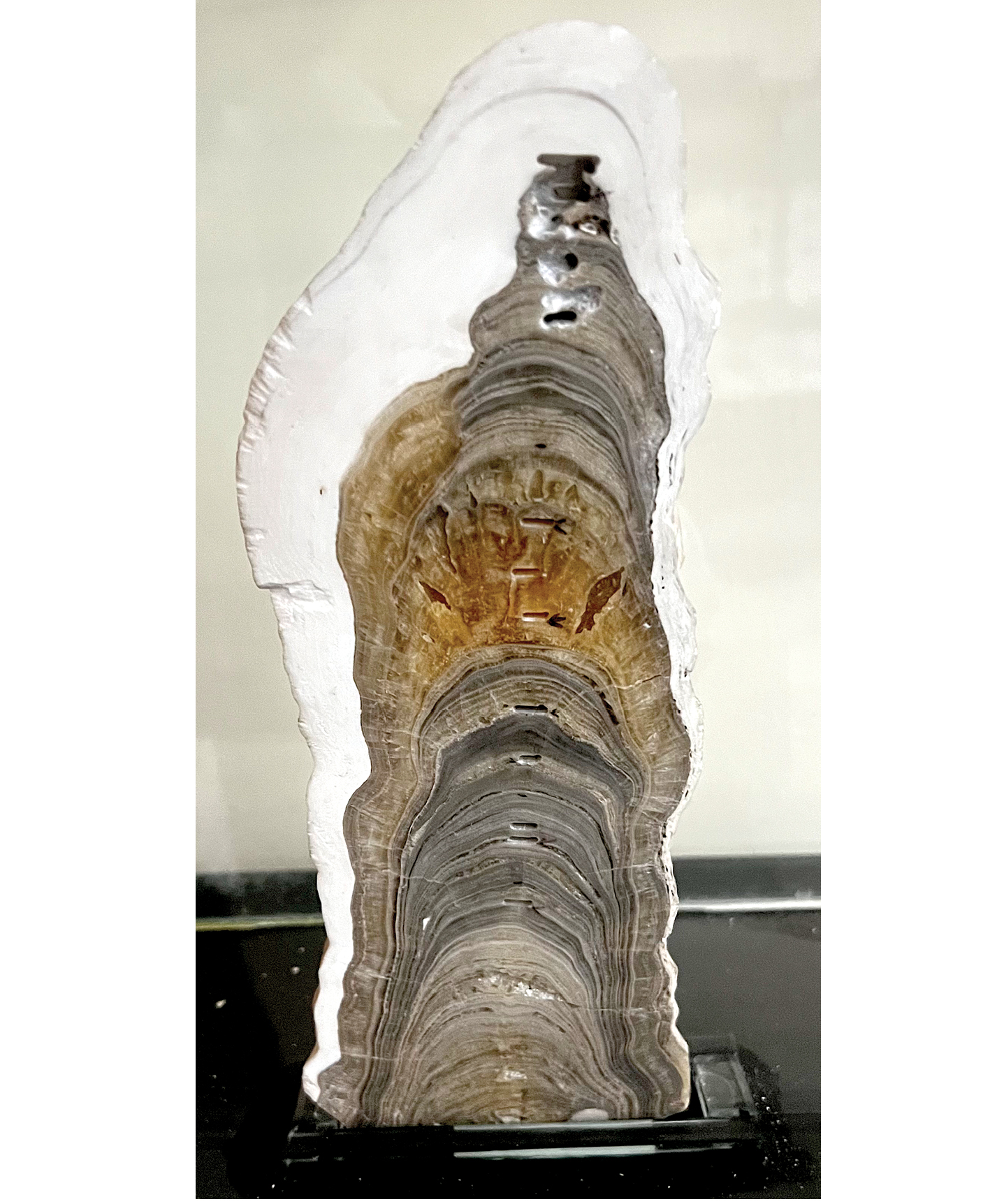
The lower boundary of the Meghalayan Stage begins at 4250 yrs before 2000 CE (Head 2019). The stalagmite retrieved from Mawmluh Cave (Fig. 2) is also the Global Boundary Stratotype Section and Point (GSSP). The δ18O data from this U/Th dated speleothem shows an abrupt climatic change at the 4.2 ka event, which has become a benchmark for the study of climate impact on human civilizations across Europe and Asia.
The 4.2 ka event forms the basis of the Meghalayan Stage/Age and the coincident subseries/subepoch of the Late/Upper Holocene (Walker et al. 2018). The Birbal Sahni Institute of Palaeosciences in Lucknow, India, conserves the type specimen of the Meghalyan Stage and the speleothem KM-A from Mawmluh Cave in Meghalaya (Fig. 2).
Holocene event and its cultural response to civilization
 |
|
Figure 2: Speleothem KM-A from the Mawmluh Cave, Meghalaya, the type specimen of the Meghalyan Stage and Upper Holocene subseries (image credit: Museum BSIP, Lucknow). |
Coupled human and environmental response of this so-called 4.2 ka abrupt climate change event are often observed in proxy records distributed globally. The northeast India region was subject to human migration towards eastern Asia during the Late Holocene (Tagore et al. 2022). This region is also known as a biodiversity hotspot, and a flora and fauna migration corridor to the subcontinent. In contrast to other regions in which there are archaeological studies available in different parts of the Middle East (Mehrotra et al. 2019), in northeast India there is a distinct lack of archaeological evidence that prevents the study of human response to the 4.2 ka event in this region, and to link it to a global civilization collapse event. Nevertheless, the recognition of the Mawmluh Cave site as a geological heritage site by the International Union of Geological Sciences, due to its key relevance for the understanding of the impact of climate change on human civilizations, proves the significance of northeast India as a recorder of the 4.2 ka event. The preservation of abrupt climatic change event signals is evident in other paleoclimatic records from northeast India (Mehrotra et al. 2019), including isotopic, palynological and sedimentological proxies. Additional and more exhaustive work is needed to find supportive evidence of human-induced changes, or coupled societal implications, during the 4.2 ka event in this region.
affiliation
Birbal Sahni Institute of Palaeosciences, Lucknow, Indiacontact
Nivedita Mehrotra: nivedita_mehrotrabsip.res.in
references
Bera SK, Basumatary SK (2013) Journal of Paleosciences 62: 1-10
Bond GC et al. (2001) Science 294: 2130-2136
Dixit Y et al. (2014) Geology 42(4): 339-342
Ghosh R et al. (2014) Quat Int 325: 13-29
Ghosh R et al. (2015) Quat Sci Rev 114: 100-115
Head MJ (2019) Quat Int 500: 32-51
Hong YT et al. (2003) Earth Plan Sci Lett 211(3-4): 371-380
MacDonald G (2011) Quat Int 229: 140-148
Mehrotra N et al. (2019) Quat Int 507: 206-216
Staubwasser M et al. (2003) Geophys Res Lett 30: 1425
Tagore D et al. (2022) Front Genet 13: 1023870