PAGES Magazine articles
Ilham Bouimetarhan![]() 1 and Rachid Cheddadi
1 and Rachid Cheddadi![]() 2
2
Session OSM19 at the PAGES 6th Open Science Meeting, online, 16 May 2022
About two-thirds of Africa is arid or semi-arid, and water availability is a critical factor for the wellbeing of ecosystems and anthropogenic activities. Studies of regional hydrologic fluctuations in Africa since the Last Glacial Maximum (LGM) reveal profound implications and impacts on ecosystems and human societies. Reconstructions of paleoenvironmental changes in such critical environments are often hindered by the lack of suitable archives under arid conditions. The 6th Open Science Meeting (OSM) session OSM19, "Understanding past hydrological changes in Africa since the Last Glacial Maximum", was proposed in an attempt to build African research synergies, and provide an overview of the recent research on past climate change since the LGM from different regions in Africa. In this context, the session aimed to provide a better understanding of the spatio-temporal variability of hydrologic changes over Africa since the LGM. This session was dedicated to identifying new hydrological records from Africa, including terrestrial and marine records, with a time span that covered the last 20 millennia. Although the conference was completely online, the session successfully attracted diverse contributions that provided an overview of the ongoing science inland and offshore of the African continent. This session provided a scientific platform to share new records from different areas and time periods based on very interesting proxy records and model simulations to identify long-term climate variabilities, explore mechanisms and dynamics underlying the observed climate changes, and address the impact that hydrological change has had on the evolution of ecosystems and human activities. The session was attended by more than 90 participants, with eight oral contributions and eight posters that presented and discussed the state-of-the-art research of the African hydrological changes since the LGM.
 |
|
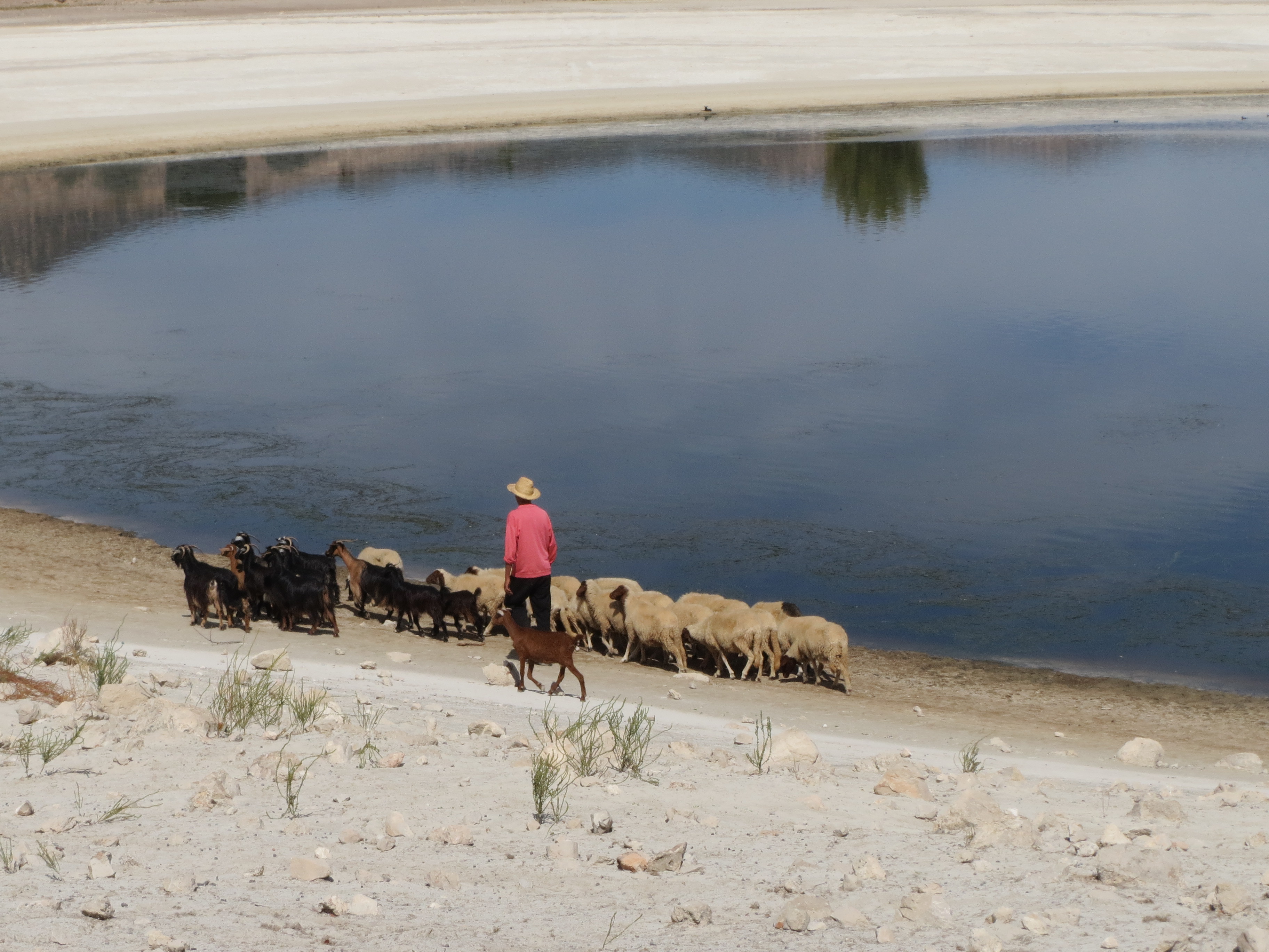
Figure 1: Ecosystem–climate–human interaction in Lake Afourgah (Middle Atlas at 1420 m above sea level, Morocco). |
The session was built around three key research foci: (1) paleohydrological and paleoenvironmental changes during the LGM, (2) anthropogenic vs climate effects on African environments during the LGM, and (3) data–model synthesis of spatiotemporal variations in African hydroclimate since the LGM. Panelists (over 60% were early-career researchers) presented their latest research from different parts of Africa and provided a few recommendations. This session highlighted the increasing need of new data for both past climate reconstructions and model simulations/improvement in order to fill existing gaps and obtain a more complete overview of the LGM African hydroclimate. This task can only be fulfilled in a collaborative framework between the marine and terrestrial research communities, and between data and modeling communities. We therefore all agreed to put further efforts into: (1) comparing and integrating, simultaneously and independently, terrestrial and marine records in paleoclimate interpretations; (2) investigating tropical influence on hydroclimate variation in the hyper-arid central Sahara; (3) generating more Late Quaternary Aeolian-fluvial paleoenvironmental archives in Africa; (4) reconstructing high-resolution hydroclimatic and vegetation changes using historical archives and multi-proxy sediment records and (5) providing data–model synthesis of hydroclimatic proxies over Africa. Possibilities are presently being explored to collaborate on these research foci.
The session conveners were satisfied with the quality and the diversity of oral and poster presentations, as well as with the gender balance and the geographical representation. However, we strongly felt that the session was dominated mainly by research from North Africa and the central and eastern Sahara desert. Additionally, the session conveners would like to emphasize that although African climate mechanisms and impacts on regional and local ecosystems can be partially studied by the international community, an increased international scientific effort toward involving institutional cooperation with locally based African scientists, especially West and East Africa, is necessary to make significant progress in this field.
affiliationS
1Faculty of Applied Sciences, Ibn Zohr University of Agadir, Morocco
2ISEM, University of Montpellier, CNRS, IRD, France
contact
Ilham Bouimetarhan: i.bouimetarhan@uiz.ac.ma
Michael N. Evans![]() 1,2, B. Valero Garcés
1,2, B. Valero Garcés![]() 3, C. van Rensburg4, Y. Ait Brahim
3, C. van Rensburg4, Y. Ait Brahim![]() 5, N.B. Schafstall
5, N.B. Schafstall![]() 6, G.M. Falster
6, G.M. Falster![]() 7,8 and K.J. Meissner
7,8 and K.J. Meissner![]() 8,9
8,9
Roundtable at the PAGES 6th Open Science Meeting, online, 16 May 2022
PAGES recognizes the need to consider concerns about inclusivity and diversity in all aspects of its activities. In advance of the PAGES Open Science Meeting (OSM), and reflecting desires expressed by the PAGES community, an Inclusivity Committee was formed (pages-osm.org/index.php/general-information/diversity-and-inclusion). The inclusivity and diversity roundtable was integrated into the virtual meeting plan of the OSM. Held on 16 May 2022, it was attended by over 90 people from 26 countries.
The roundtable and its outcomes
Discussion of the following questions at the roundtable produced a number of ideas for consideration:
- How can PAGES obtain more information about diversity and equity concerns? The recommendation was to create a PAGES email address, monitored by a standing committee, to which the community could report problems.
- Have you ever felt excluded from a PAGES sponsored event, and if so, how? No one present for the roundtable volunteered an example, but we imagine there might be reports if an anonymous survey were to be taken of the entire PAGES community.
- What are some examples of ways in which PAGES has improved the inclusion of members of underrepresented geographical areas, sociodemographic groups, or in any other ways in its activities and leadership? The discussion noted that PAGES hosts open webinars and requires consideration of career stage and geographic representation at workshops, but could do more.
- How could PAGES be more inclusive? PAGES could expand its definition of representation and diversity into sociodemographic considerations; encourage hybrid activities that consider time zones, internet connectivity, and systemic barriers to participation by underrepresented groups; create virtual platforms and networking to train a more diverse community in data analysis, a core activity; and give agency to researchers working in underrepresented regions. The PAGES Early-Career Network (pastglobalchanges.org/ecn) provides excellent examples of all these initiatives.
- What activities and initiatives might a standing PAGES Inclusivity and Diversity Committee pursue? Participants suggested that such a committee would need clear goals and planned outcomes, and to provide regular updates to the community for discussion. New initiatives could include a mentoring program to build capacity in students and early-career researchers, increasing diversity in PAGES' management, SSC, and working group leadership, and publishing a code of conduct or community charter spanning all PAGES activities.
 |
|
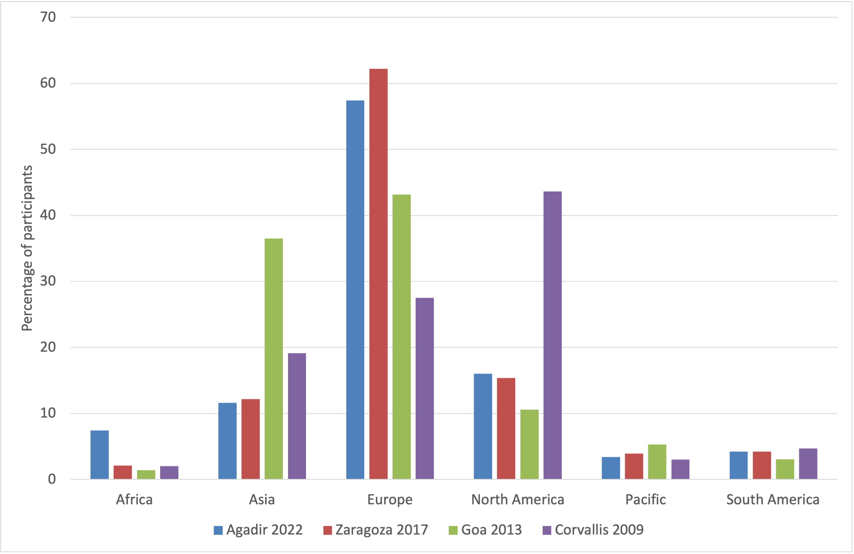
Figure 1: PAGES OSM attendance over time and by location since 2009. Meeting participation roughly reflects PAGES membership distribution and, notwithstanding the COVID-19 pandemic, the growing popularity of the OSMs. Participation data is somewhat skewed by location toward participants from nearby, but otherwise tends to include relatively large proportions of affiliations from Europe and North America. |
The path forward
The PAGES International Project Office (IPO) and Scientific Steering Committee (SSC) are actively discussing how diversity and inclusivity might be improved by governance and operational changes. PAGES does not tolerate discrimination or harassment at workshops or meetings and is committed to an open and welcoming environment. But to achieve these goals, we must make education, training, and dialog accessible across the PAGES community. Because PAGES is globally dispersed, we might be best served by self-paced programs. Excellent resources, including the URGEoscience (2020) anti-racism (urgeoscience.org/curriculum) and Safe Zone (2022) LGBTQ+ (thesafezoneproject.com/curriculum) curricula, are available. Finally, we need to set specific goals and regularly assess outcomes. A standing committee or an annual SSC agenda item might meet this need. Everyone gains from progress toward a more just, diverse, and inclusive intellectual community (Willenbring 2020), itself the root of a more creative and dynamic marketplace of ideas (McGee 2021).
Acknowledgements
We are grateful to the local organizing committee of the OSM for hosting the roundtable, attendees for offering their thoughts and ideas, Sarah Eggleston for the illustration, and Marie-France Loutre, Stella Alexandroff, Martin Grosjean, and Willy Tinner for helpful discussions.
affiliationS
1Department of Geology and Earth System Science Interdisciplinary Center, University of Maryland, College Park, USA
2School of GeoSciences, University of Edinburgh, UK
3Instituto Pirenaico de Ecología, Spanish Scientific Research Council (IPE-CSIC), Zaragoza, Spain
4PAGES International Project Office, Bern, Switzerland
5International Water Research Institute, Mohammed VI Polytechnic University, Benguerir, Morocco
6Czech University of Life Sciences, Prague, Czech Republic
7Research School of Earth Sciences, Australian National University, Canberra, Australia
8ARC Centre of Excellence for Climate Extremes, Australia
9Climate Change Research Centre, University of New South Wales, Sydney, Australia
contact
Blas Valero Garcés: blas@ipe.csic.es
Michael N. Evans: mnevans@umd.edu
references
McGee H (2021) The Sum of Us: What racism costs everyone, and how we can prosper together. Profile Books, 448pp
The Safe Zone Project (2022) The Safe Zone Project. thesafezoneproject.com, accessed 10 Oct 2022
URGEOSCIENCE (2020) Unlearning racism in geoscience. urgeoscience.org, accessed 6 Sept 2022
Ilham Bouimetarhan![]() 1, R. Cheddadi
1, R. Cheddadi![]() 2, H. Reddad
2, H. Reddad![]() 3, A. Baqloul
3, A. Baqloul![]() 1, M. Carré
1, M. Carré![]() 4, A. Abouhilal
4, A. Abouhilal![]() 3 and the local organizing committee
3 and the local organizing committee
PAGES 6th Open Science Meeting, online, 16-20 May 2022
What would have been an in-person conference in May 2021 in Agadir, Morocco—with on-site sessions, and informal talks during the coffee breaks or at the Agadir bay—turned into an online meeting, postponed due to the world pandemic and uncertainties related to travel restrictions, marking a first in the history of the PAGES Open Science Meetings (OSM; pages-osm.org). Although completely online, we were proud to bring the global paleo community together: 505 participants from 46 different countries attended the 6th OSM online. Among the participants, 40% identified as female; 67% of the attendees were senior researchers; and 33% were students. While 83% of our delegates came from high-income countries, only 17% were from low- and middle-income countries.
The program of this virtual OSM was built around PAGES' scientific themes of climate, environment, and humans, and featured 430 abstracts presented in 31 sessions as 129 posters, 128 lightning talks, and 301 oral presentations, with four parallel sessions running simultaneously. The program included the first PAGES OSM session dedicated to art and science: "Art and science in a changing planet: A past global perspective." Nine keynote speakers provided state-of-the-art contributions on a wide range of paleoscientific topics encompassing glacial refugia and future microrefugia evolution (Rachid Cheddadi, France), the origin of Homo sapiens (Jean-Jaque Hublin, Germany), high and low latitude climate interactions (Hai Cheng, China), learning from past tipping points to avoid future ones (Tim Lenton, UK), the role of paleoclimate model–data comparisons in assessing climate projection levels of confidence (Pascale Braconnot, France), savanna fire response to paleo-rainfall shifts (Alison Karp, USA), flood history of the Himalaya (Pradeep Srivastava, India), dendrochronology and climate in the tropical Andes and lower lands (María Eugenia Ferrero, Argentina), and a past–present–future perspective on using paleoecology to conserve African ecosystems (Lindsey Gillson, South Africa).
Four town halls were organized during the OSM, and were well attended. These included an inclusivity roundtable, a PAGES–Ocean KAN meeting, a workshop on archiving data in community repositories, and a town hall run by the PAGES 2k Network. Despite the fact that the online meeting format did not promote as much social interaction between the participants as it would have in Agadir, the local organizing committee organized a virtual conference dinner where a Moroccan chef guided attendees through some local dishes in a two-hour cook-along session. This session was attended by 30 food lovers from 13 countries.
 |
|
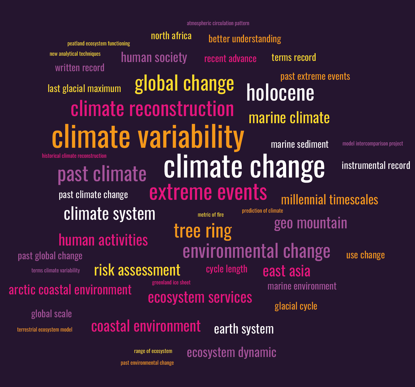
Figure 1: Word cloud based on the scientific sessions of the 6th Open Science Meeting (Image credit: Lindsey Gillson). |
Given the virtual global attendance and the organizational time zone hurdles, all oral contributions were live broadcasts and recorded. The recordings were then made available on the virtual platform to all attendees during the conference and until one month after its end. Currently, all plenaries and opening and closing ceremonies are accessible via the PAGES YouTube channel: youtube.com/PastGlobalChanges/playlists
This online meeting aroused the interest of the local press, with at least six articles in both Arabic and French (mapbenimellal.ma/fr/beni-mellal-ouverture-des-travaux-de-la-conference-internationale-pages-sur-les-changements-climatiques).
The 6th OSM would not have been possible without the strong and sustained commitment of all members of the organizing and scientific committees over almost two years, as well as the great help of the Shocklogic team for managing the online event. We have learned so much about the latest global change research and seen how paleoscientists are undertaking enormous efforts to assess the high complexity of past global changes to gain a better understanding of the general forces controlling them. We thank all participants for their valuable contributions and for taking part actively in the discussions during the conference to make it a successful event, and we hope to see you in person at the PAGES 7th OSM!
affiliationS
1Ibn Zohr University of Agadir, Morocco
2ISEM, University of Montpellier, CNRS, IRD, France
3University of Sultan Moulay Slimane of Beni Mellal, Morocco
4LOCEAN, Sorbonne University (Pierre and Marie Curie University), Paris, France
contact
Ilham Bouimetarhan: i.bouimetarhan@uiz.ac.ma
Juliana Nogueira1,2 and Runa Reuter3
PAGES 4th Young Scientists Meeting, online, 9-13 May 2022
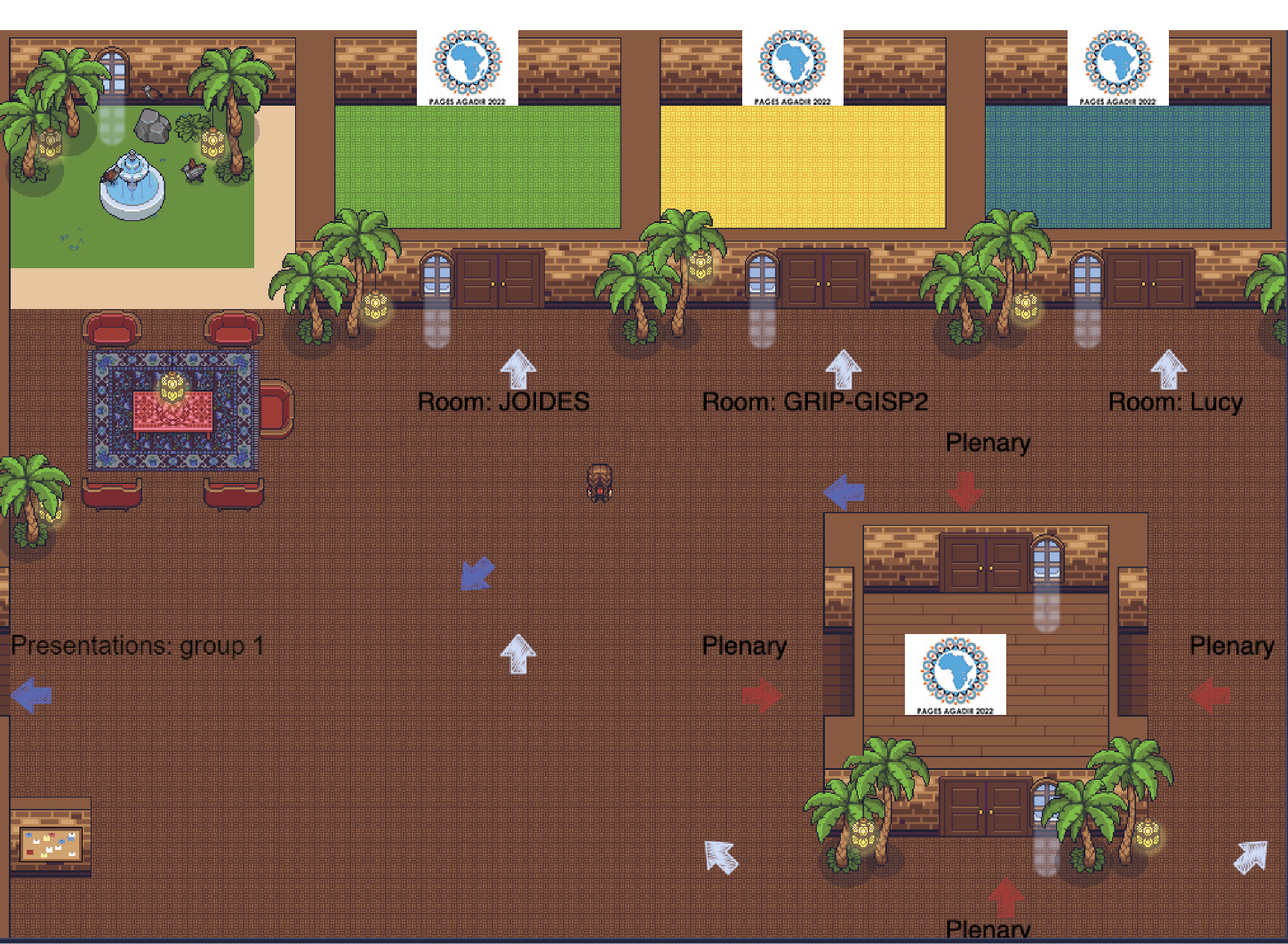
The pandemic has brought diverse challenges and a new dynamic to scientific conferences and meetings. The PAGES Young Scientists Meeting (YSM), first held 13 years ago in Corvallis, OR, USA, took place online for the first time in 2022. With adversities comes the opportunity to learn new approaches and improve or adapt old ones. The YSM, already a well-established event, occurs during the week preceding the PAGES Open Science Meeting (OSM) and is a chance for early-career researchers (ECRs) to network and participate in small-group discussions and specialized training sessions. The 4th YSM was meant to have taken place just outside the beautiful city of Agadir, Morocco. However, the circumstances led the participants to join in a different setting, unknown to most until then: the online platform GatherTown (gather.town). Fifty-four participants from 21 countries met in the virtual environment, presenting themselves as personalized avatars. A conference venue was simulated in the style of a 16-bit video game, like the ones very familiar to many of the young participants from "back in the day" (Fig. 1)! By moving the avatars around the scene, one could directly interact with other participants and easily engage in conversations.
For five days, participants could stroll between four breakout rooms and discuss four (out of 12) different topics based on their interests. In a very informal atmosphere, aided by the playfulness of the setting, experienced scientists shared their expertise and knowledge with the next generation of young scientists, providing training in both soft and technical skills. The topics discussed included "social media for scientists", "the right balance between research and private life", "be a part of the climate change solution", "grant-funding agencies", and "career path", among others. As there were participants from all over the world, two groups were formed, and live events were carried out twice a day to accommodate different time zones. The posters and lounge, however, were accessible anytime during the event. This setup sparked insights due to the exposure to various research topics, and encouraged discussions among people with similar scientific interests.
Furthermore, in terms of social interactions, the 4th YSM was full of socializing opportunities, including a cooking competition in which participants learned how to cook traditional Moroccan couscous. Acting skills were called upon in the game Climate Cluedo, where participants were assigned roles as climate scientists or climate skeptics, with the goal of convincing the others to switch to their side by using sets of arguments sent previously to the participants by the organizers. This activity allowed for indepth conversations with other participants while breaking the ice and facilitating networking.
 |
|
Figure 1: The virtual YSM setup at a glance. The main lobby, themed in Moroccan style, allowed people to interact and stroll between the different sessions held in the breakout rooms, the plenary hall, and the presentation rooms. |
The 60 abstracts presented during the meeting covered a large number of topics. The studies, spanning timescales ranging from the Miocene to the recent past, involved a wide range of environments across the five continents and used different natural and historical archives, in addition to models. Important and timely topics were discussed, such as climate teleconnections, extreme events including drought and floods, climate reconstructions, environmental and hydrological changes, methodological approaches to improve reconstructions, cyclicity, and detection of climatic modes of variability, among others. The posters, some of which included an accompanying video, were available in the virtual poster room and participants received feedback from their colleagues to help improve the quality and presentation of the studies. The diversity of the topics highlighted the advances and improvements in past climate studies performed by ECRs, giving a glimpse of what to expect in the future of paleo research.
The keyword that sums up the 2022 YSM is inclusion. The digital format has strong advantages, such as a low carbon footprint and greatly reduced costs. Although challenging, this edition allowed ECRs from various nationalities to break geographic borders and enroll in a meeting that promoted interactions among the next generation of paleoscientists, encouraging new friendships, collaboration, and knowledge exchange. And maybe the conference's theme, "Lessons from the past for a sustainable future", coincidentally hints that this year's meeting was a lesson for a sustainable future when it comes to scientific meetings.
affiliationS
1Faculty of Forestry and Wood Sciences, Czech University of Life Sciences Prague, Czech Republic
2LARAMG-Radioecology and Climate Change Laboratory, Rio de Janeiro State University, Brazil
3Leibniz Institute for Baltic Sea Research, Warnemünde, Germany
contact
Juliana Nogueira: de_sousa_nogueira@fld.czu.cz
Basil A.S. Davis![]()
Almost every paleoscience laboratory has a store containing sediment cores and other samples collected during fieldwork. In some cases, this material will have been selected for analysis and eventually published. However, often the material remains unanalyzed and held either as a backup or for potential future projects. The contents of many fieldwork sediment stores, therefore, often represent an underutilized resource for the laboratory that stores it, the organizations that funded it, and the broader paleo community that could also make use of it. SEDI-SHARE is a new community initiative supported by both PAGES and the International Union for Quaternary Research (INQUA; inqua.org) that aims to make better use of these samples held in storage.
Fieldwork is often expensive, difficult, and time consuming, especially if it involves travel to remote and inaccessible locations. This travel has monetary costs and costs in terms of its carbon footprint. Access to fieldwork sites may also be difficult because of political, logistical, or health reasons such as COVID-19. Regions that were once accessible for fieldwork in the past may no longer be accessible, or access may be restricted to certain nationalities, or only for certain activities. Laws may also change to restrict access or sediment removal from a location, or sites may be lost forever due to construction, agriculture, and drainage.
There could, therefore, be many benefits if there was greater collaboration and utilization of sediment samples held in storage throughout the world. For instance, by helping to expand the number of modern surface samples used in calibration datasets, or helping to fill significant gaps in the global distribution of studies, such as in Asia, the tropics, and the Southern Hemisphere. It would also be easier to identify cores or samples where existing analyses could be supplemented to provide a multi-proxy perspective or higher temporal resolution, for instance, to evaluate a new proxy or methodology, or to investigate the effects of a specific short-term event.
Sample sharing could also help promote collaboration between those institutes with analytical resources and those with sediment and fieldwork resources, a situation that often exists between institutes in higher- and lower-income countries. In addition, sample sharing could also encourage collaboration with other disciplines since the collection of sediment cores and surface samples is also part of many disciplines, including plant science, soil science, limnology, archaeology, and environmental pollution.
Importantly, greater visibility and international recognition of sample stores could also help to ensure their continued support within institutions where they increasingly compete with other priorities. Stores take up valuable space and technician time, and can involve significant annual servicing and refrigeration costs. Many stores also operate at capacity. Every year, difficult decisions have to be made as to which samples to keep and which to throw away, resulting in the potential loss of scientifically valuable and sometimes irreplaceable material.
 |
|
Figure 1: The contents of many fieldwork sediment stores often represent an underutilized resource for the laboratory that stores it, the organizations that funded it, and the broader paleo community that could also make use of it (Photo credit: IODP-USIO NSF). |
While the contents of sediment stores are generally well documented, this information is usually held offline or restricted to within an institutional domain. Some larger institutions and long-standing international collaborative activities, such as the Ocean and Continental Drilling Programs, already provide information online through the National Oceanic and Atmospheric Administration/Index to Marine and Lacustrine Geological Samples1 platform for geological samples. This platform, however, has limited functionality and includes samples from many different geological time periods. More recently, other more sophisticated platforms have been developed with a Quaternary focus, including the US-funded Open Core Data2 and the French Cybercore3 project.
With these recent technological innovations and other developments, such as the growing use of International Generic Sample Numbers (IGSNs)4, the time seems right to try to bring the paleo community together to develop the necessary digital infrastructure, metadata standards, and management protocols that will enable information about samples in storage to be shared much more widely than at present. This will not be without its challenges, not least how to support the participation of smaller laboratories with only limited resources. One idea is to provide labs with a certification system that means they could initially put their sediment store inventory online with the minimum of metadata and then work towards improving it over time through a series of certified steps. This approach would allow a lab to initially participate with minimal effort, while at the same time providing a clear pathway with the reward of international recognition that could be used to gain internal institutional support.
The initial objective of SEDI-SHARE is to bring the paleo community together to discuss these issues through a series of meetings and open workshops to establish common goals and objectives, and to help identify problems and solutions. All areas of the community are encouraged to contribute to this dialogue, no matter what field or how large or small the laboratory. Following this consultation period, SEDI-SHARE will then work towards delivering the necessary digital infrastructure and other measures necessary to overcome current hurdles to sample sharing. In the long-run, SEDI-SHARE hopes to reduce the necessity for fieldwork and therefore bring down costs, maximize investment, encourage collaboration, and create new scientific opportunities in accordance with today's open science (OECD 2015) and FAIR principles (Wilkinson et al. 2016).
If you are interested in participating and would like to be kept informed or contribute ideas, please contact Basil Davis and/or register your interest here: forms.gle/Tk1vYH8AJt15E1wz6
affiliation
Institute of Earth Surface Dynamics (IDYST), University of Lausanne, Switzerland
contact
Basil Davis: basil.davis@unil.ch
references
Wilkinson MD et al. (2016) Sci Data 3: 160018
Links
1https://www.ngdc.noaa.gov/mgg/curator
Linus B. Ajikah1,2, O.H. Adekanmbi3, E.A. Orijemie4, M. Bamford1 and E. Phiri5
To study the upsurge of changes in vegetation around the coastal environment of Southern Nigeria (CESN) and assess the impacts of these changes, Dr. Linus Ajikah, from the University of Calabar, Nigeria, traveled to Stellenbosch University, South Africa, as a PAGES Inter-Africa Mobility Research Fellow. There he collected data on the distribution of palynomorphs using a scanning electron microscope (SEM), which were used to infer changes in vegetation characteristics of the CESN in the past.
The Holocene epoch, the latest interval of geologic time, covers approximately the last 11,700 years of Earth's history. It is an era of globally pervasive and steeply increasing anthropogenic influence on the Earth system. In West Africa and other parts of the tropics, the late Holocene (4500 yr BP–present) has been characterized by fluctuating environmental conditions, resulting in the fragmentation of rainforest ecosystems, the increase in secondary forests (Sowunmi 1981a, b), the decline in the freshwater and mangrove swamp forests vis-à-vis the emergence of coastal savannas (Orijemie and Sowunmi 2014), and the drastic fall in sea and lake levels (Tossou et al. 2008). These environmental changes have not only affected vegetation and hydrological systems but have also impacted human societies and cultural transformations that contributed to the collapse and emergence of complex societies and their food production systems (Kay et al. 2019). The swamps that make up the coastal environment of Southern Nigeria (CESN) have recorded severe loss of habitat and biodiversity. This loss causes damage to the ecosystem through time due to petroleum exploration, population increase, and associated anthropogenic activities in the area. These have often resulted in the loss of vegetation, extreme weather, and climatic conditions. There is limited concern for the implications of these changes on vegetation and climate amongst the local communities and government. This is due to poor knowledge of the changes in land cover around these coastal environments; also, very little is known about the changing chronological record of the land cover and climate of the CESN.
Thus, the aim of this study was to reconstruct the past vegetation of selected locations around the CESN and infer important climatic parameters during the Holocene. An important aspect of this research was to develop an atlas, or pollen library, of photo and SEM micrographs of palynomorphs to enable the accurate identification of materials recovered from other CESN sites.
Methods
Samples were collected at 10-cm intervals to a depth of 3 m, using a universal peat corer. Subsamples were then subjected to standard palynological, sedimentological, pH, and salinity analyses (Erdtman 1969; Faegri and Iversen 1989). For the SEM, samples were mounted onto standard 12-mm aluminum SEM stubs and sputter-coated with a thin layer of gold to enhance conductivity. Images were visualized and captured with a Zeiss Merlin field emission at the Central Analytical Facility, Stellenbosch University, South Africa.
Findings
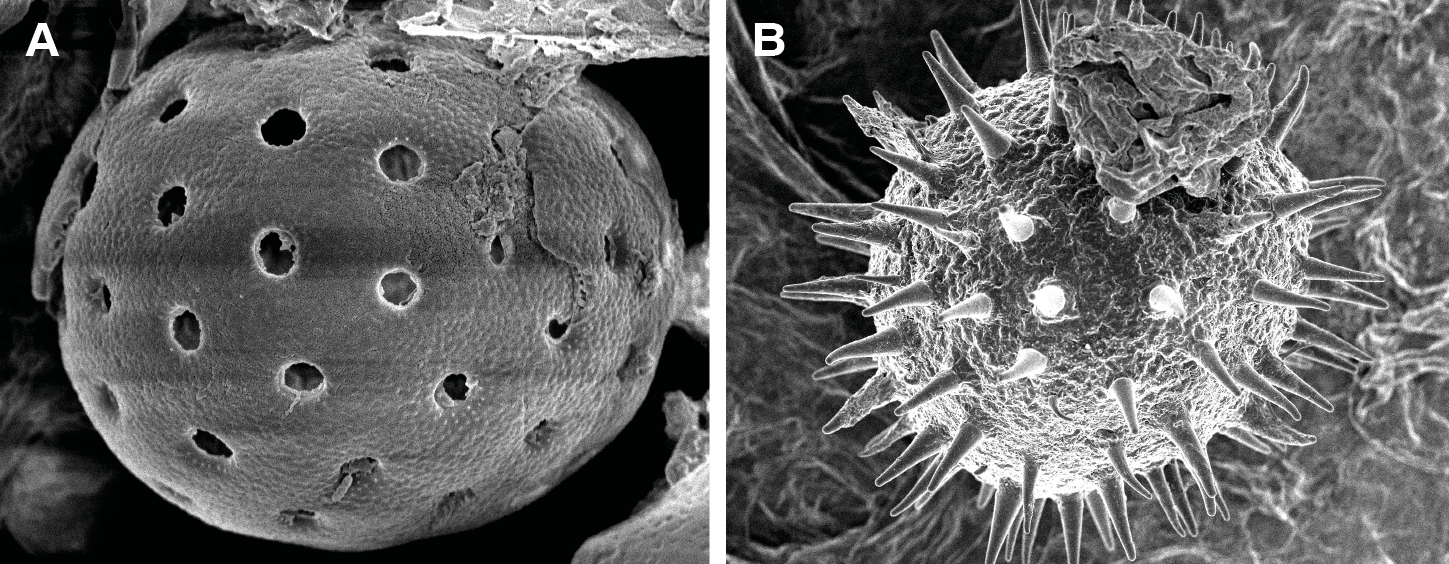
A total of 42 palynomorph types were recovered. The pollen sum ranged from 158 to 1601, with 79 SEM pollen and spore photomicrographs captured (Fig. 1). Dominant palynomorphs included Symphonia globulifera, Cyclosorus spp, and Poaceae. Other palynomorphs were Alchornea sp, Aspilia africana, Nephrolepis bisserata, Polypodium spp, and fungal spores.
 |
|
Figure 1: SEM images of (A) Chenopodiaceae/Amaranthaceae and (B) Malvaceae. |
Three phases of environmental change were identified with the oldest phase (phase I, 1510–1480 yr BP) comprising a complex mixture of mangrove swamp forest, freshwater swamp forest, ferns, and open vegetation. The rainforest was present but reduced in area. Phase II was similar but with low mangrove and rainforest but with some more open vegetation taxa. This was most likely a result of the impact of human activities, and possibly some local dry conditions. In phase III, the environment became more open; the mangroves expanded, but the rainforest area remained low. Conditions became wetter; the area was likely exposed to flooding, and human activities increasingly interfered with the environment. For the last 1400 years, the rainforest has witnessed significant natural changes that were compounded by anthropogenic-driven disturbances. Varied lithological types were recognized, ranging from fine grains to silty sediments suggesting overbank or floodplain settings of a low energy regime. The pH and salinity values also varied considerably, according to the cored depths and sites, while the analyses revealed a mosaic of the sedimentary depositional environment in which the recovered palynomorphs were preserved.
affiliationS
1Evolutionary Studies Institute, University of the Witwatersrand, Johannesburg, South Africa
2Department of Plant and Ecological Studies, Faculty of Biological Sciences, University of Calabar, Nigeria
3Department of Botany, University of Lagos, Nigeria
4Department of Archaeology and Anthropology, University of Ibadan, Nigeria
5Department of Agronomy, Faculty of AgriSciences, Stellenbosch University, South Africa
contact
Linus Ajikah: linusajikah@gmail.com
references
Erdtman G (1969) Handbook of Palynology Morphology, Taxonomy, Ecology: An Introduction to the Study of Pollen Grains and Spores, 1st Edition. Hafner, 486 pp
Faegri K, Iversen J (1989) In: Faegri K et al. (Eds) Textbook of pollen analysis, 4th edition. John Wiley and Sons, 69-91
Kay AU et al. (2019) J World Prehist 32: 179-228
Orijemie EA, Sowunmi MA (2014) In: Stevens CJ et al. (Eds) Archaeology of African Plant Use. Left Coast Press, 103-112
Sowunmi MA (1981a) Pollen et Spores 23: 125-148
Patricia Piacsek![]() 1, J.P. Bernal1, J.T.A. Raphaelli2, R.E. Santelli3 and N. Stríkis2
1, J.P. Bernal1, J.T.A. Raphaelli2, R.E. Santelli3 and N. Stríkis2
Dr. Patricia Piacsek, from Brazil, traveled to the Universidad Nacional Autónoma de Mexico as a PAGES-IAI International Mobility Research Fellow (22 January – 1 March 2022) to study the effects of precipitation anomalies in the speleothem geochemistry, based on monitoring studies from caves located in the savannah-like biomes. Within this project, Patricia and her collaborators intend to expand our understanding of climate controls on uranium isotope composition in cave drip water and speleothems.
Increases in global average temperatures substantially impact the variability of extreme climatic events, with frequent adverse effects on the hydrological regime of the tropics. In regions with seasonal climates, such as the Brazilian Cerrado, the accumulation of negative precipitation anomalies and heatwaves increase the risk of hydrological droughts, triggering damage to ecosystems, the agricultural sector, and the entire supply chain related to it. Reconstruction of the hydrological variability beyond the instrumental series is essential to understanding the periodicity and intensity of extreme events over the natural modes of climatic variability. This allows us to better project drought risks.
Variations in trace elements in speleothems are strongly coupled with karst hydrology regime change. However, the application of trace elements in speleothems to the reconstruction of local precipitation is not yet well understood, as the complexity of the geochemical processes in the karst system hampers the possibility of a general model to explain trace-element variations. Stirling et al. (2007) showed that oxidation-reduction processes during water percolation and mineral weathering can generate considerable uranium (U) isotope fractionation. This is due to the fact that 235U fractionates from 238U during chemical reduction of uranium in ambient temperature groundwater and is preferentially incorporated into speleothems. Thus, analyses of U isotope composition in precipitated calcite on an artificial substrate of monitoring caves have the potential to allow us to estimate the appropriateness of speleothems as a proxy for external climatic conditions of the past.
Trace-element error factor
The Anjos cave is located in Central Brazil, within the São Francisco River Basin (Fig. 1a). Studies have shown that the CO2 levels within the cave are strictly dependent on the semi-deciduous vegetation above the cave (Azevedo et al. 2021; Novello et al. 2021). The development of thicker soil and denser vegetation during the rainy season (November to April) enhances the CO2 levels inside the cave. In this study, we investigated the environmental controls of U concentrations based on precipitated material on an artificial substrate at four drip sites at Anjos Cave. Drip sites 1 and 3 have intermittent drip flows, whereas the flows at drip sites 2 and 4 are continuous. However, despite these differences, the ratio of the trace elements Mg/Ca, obtained with ion chromatography with mass spectrometry (IC-MS), indicates the decay trend of the trace elements (Fig. 1b).
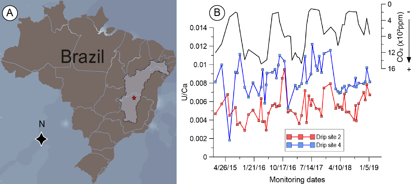 |
Under normal conditions of prior calcite precipitation (PCP), the progressive reduction of the Mg/Ca ratio would indicate an increase in regional precipitation. If the PCP modulates Mg/Ca and Sr/Ca variability, the logarithms of the molar ratios (mol Mg/mol Ca and mol Sr/mol Ca) should co-vary linearly, with a slope of 0.88 ± 0.13 (Sinclair 2011). The resulting slope (m > 1) of all drip sites indicates that processes other than PCP have an impact on the abundances of Mg and Sr in the stalagmite. Therefore, the Mg/Ca from these drip sites failed to indicate that PCP was the main driver of the observed trace-element variability. In fact, a decrease in precipitation was observed, and CO2 levels inside the cave progressively decreased.
Uranium isotopes as an alternative proxy for hydrological oscillations
In contrast to trace elements, the uranium to calcium ratio (U/Ca) of drip water showed seasonal variability throughout the record. The drip sites with distinct fracture structures on the host rock (intermittent and continuous) showed opposite trends in U/Ca concentrations. The difference between the drip points may be related to the residence time of the water percolation with the host rock. We interpret seasonal U/Ca variations from the continuous drip point as reflecting changes in the seasonal rainfall amounts, where positive ratio values seem to be related to dry periods and low CO2 levels inside the cave.
Our results suggest that the U/Ca behavior of speleothems varies as a function of the hydrology of the dripping points; this suggests that U concentration in dripping solution is strongly tied to changes in rainout, indicating that U/Ca values in speleothems from continuous drip are excellent proxies for rainfall variability. However, other competing processes, such as pre-precipitation of calcite, may lead to opposing behaviors between the dripping in response to changes in hydrology. The monitoring results are important for the reconstruction of the hydrological variability over the last few centuries in the São Francisco River Basin.
affiliationS
1Centro de Geociencias, Universidad Nacional Autónoma de México (UNAM), Mexico City, Mexico
2Departamento de Geoquímica Ambietal, Fluminense Federal University (UFF), Niterói, RJ, Brazil
3Departamento de Química Analítica, University of Rio de Janeiro (UFRJ), Brazil
contact
Patricia Piacsek: piacsekpatricia@gmail.com
references
Azevedo V et al. (2021) Earth Planet Sci Lett 563: 116880
Novello VF et al. (2021) Quat Sci Rev 255: 106822
Sinclair DJ (2011) Chem Geol 283: 119-133
Stirling CH et al. (2007) Earth Planet Sci Lett 264: 208-225
Bokanda Ekoko Eric
As one of the first PAGES Inter-Africa Mobility Research Fellows, Dr. Bokanda Ekoko Eric, from Cameroon, spent a month (11 April – 12 May 2022) at the Botswana International University of Science and Technology, where he had the opportunity to conduct measurements in the lab on mangrove sediments.
Mangroves are mostly associated with muddy, tropical deltas, and may also grow on substrates such as sand, volcanic lava, and carbonates. Within mangrove environments, there are sediments which are formed in situ (autochthonous sediments). Other (allochthonous) sediments may be transported to this environment or catchment through fluvial discharge, tidal current input, or littoral drift. The allochthonous and autochthonous sediments within these zones are powerful paleoclimate proxies.
Waterlogged and anoxic conditions, which hinder microbial degradation of organic materials, are common in below-ground carbon reservoirs. As such, carbon in blue carbon zone sediments (i.e. carbon stored in coastal and marine ecosystems) can remain buried for millennia if the sediments remain undisturbed, making them important long-term carbon sinks. Mangroves are known to be one of the most important blue carbon ecosystems, storing large amounts of carbon. According to Nyanga (2020), mangroves are able to store and stock large quantities of carbon from the atmosphere during their growing periods from 50 metric tons to as much as 220 metric tons per acre. The long-term carbon storage or sequestration per unit area is substantially higher within mangrove ecosystems than other coastal or marine ecosystems, thus playing a vital role in mitigating climate change impacts (Alongi et al. 2016).
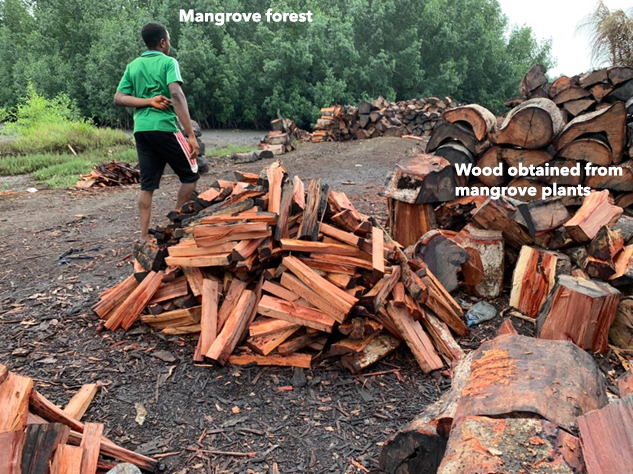
The Tiko coastal areas harbor mangrove forests that are currently being destroyed by anthropogenic activities. Due to the low standard of living and poverty, many Indigenous people within these localities have engaged in activities such as boat making and wood sales (Fig. 1). The majority of the population uses these mangroves to construct small houses and villages, which lie directly above small creeks that are flooded during high tide.
Scientific objective and activities
The objective of this project is to determine the paleoclimatic and paleoenvironmental changes that have taken place over the last 10,000 years in this region. Since these areas act as sinks for allochthonous sediments, we will also evaluate the heavy metals found within these sediments in order to evaluate how human activities and heavy-metal contamination may affect the mangrove ecology. This work will be completed in three phases.
Phase I: This phase includes field work in which we visited the mangrove areas to collect cores of ca. 1-1.5 m using a PVC tube. The cores from the two sites have already been collected. The dark and sticky nature of the cores indicate abundant organic matter and the presence of clay minerals. The color variations also show there may be significant climate variations within these areas and also an environmental shift as we move up the cores.
 |
|
Figure 1: The Tiko Mangroves. The area shown here was covered entirely by mangroves, but the region has been deforested for fossil fuels and the construction of houses and fishing boats. |
Phase II: This phase includes the laboratory work, where grain-size analyses, mineralogy, geochemistry, total organic carbon, stable isotopes of carbon and oxygen and carbon-14 dating will be performed. The first results from granulometry analyses show that most of the samples studied from the different layers are silty, silty clay, and clays. Regarding the mineralogy, preliminary results indicate the presence of clay minerals such as kaolinite, smectite, illite, and montmorillonite, as well as non-clay minerals such as quartz. The geochemistry shows high proportions of silica compared to other elements. The CaCO3 proportion in a few of the samples is at least 2%, which is far greater than most sediments obtained from lakes.
Phase III: This phase comprises the interpretation of the results, which is ongoing. With the results, we should be able to determine the amount of carbon stored in the sediments, determine the climatic and environmental variations as a function in time, and assess the effects of humans and, specifically, heavy metals which may either be natural or anthropogenic on the climate in these areas.
affiliation
Department of Geology, University of Buea, Cameroon
contact
Bokanda Ekoko Eric: eric_ekoko@yahoo.com
references
Andrew J. Christ![]() 1, J.R. Andreasen
1, J.R. Andreasen![]() 2 and J. Toller
2 and J. Toller![]() 3
3
Ice-core records from Antarctica and Greenland reveal how ice sheets responded to past climate changes and contributed to sea-level rise. These archives are critical for understanding how ice sheets may respond and raise sea level due to climate change.
Anthropogenic climate warming threatens to melt portions of the Greenland Ice Sheet (GIS) and Antarctic Ice Sheet (AIS) and raise sea level 0.2–2.4 m by the end of this century (Fox-Kemper et al. 2021; McCrimmon et al. p. 112). During the Pleistocene (2.58 Myr BP–11.7 kyr BP), cyclical changes in Earth's orbit paced the expansion and retreat of Earth's ice sheets, with corresponding drops and rises in global sea level measuring hundreds of meters. These climate oscillations imprint onto Greenland and Antarctic ice cores, which inform ice-sheet contributions to past sea-level rise.
Here, we summarize how continuous and discontinuous ice-core records are used to understand past sea-level changes. Chronologically continuous records can be compared to regional and global paleoclimate datasets to resolve the interplay between ice sheets and sea level up to 800,000 years ago. Chronologically discontinuous records can directly determine past ice-sheet configurations and thus inform ice-sheet contributions to sea level at timescales spanning into the Pliocene (5.3–2.6 Myr BP) and possibly older.
Continuous ice-core records
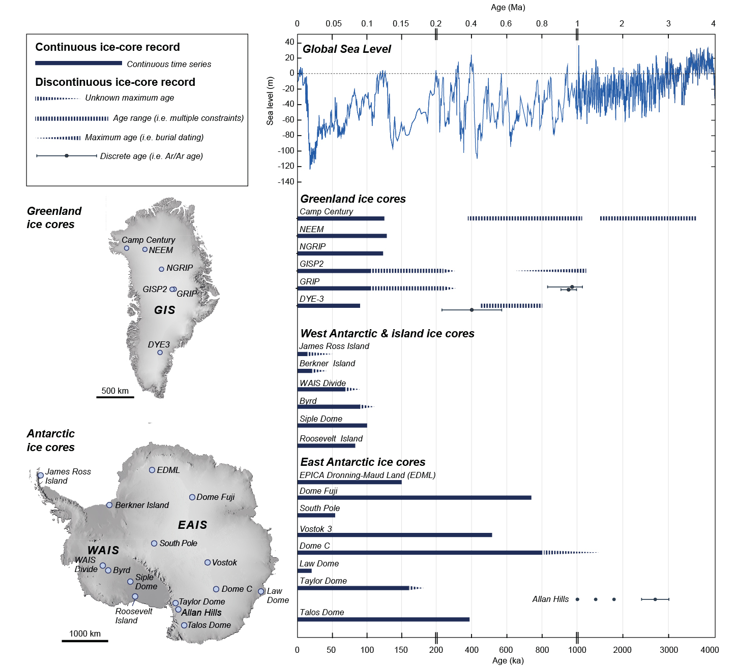
Ice cores with continuous records preserve paleoclimate data that is sustained through time. All continuous Greenland deep ice cores document Earth's climate through the Holocene (11.7 kyr BP–present) and the last glacial period (118–11.7 kyr BP), with some ice cores reaching into the last interglacial period (128-118 kyr BP; Seierstad et al. 2014; Fig. 1). In Antarctica, continuous ice cores capture much longer records that span multiple glacial–interglacial cycles up to 800 kyr BP (Wendt et al. p. 102) The time resolution of continuous ice cores can vary. For example, due to high snow accumulation rates, the West Antarctic Ice Sheet (WAIS) Divide Core (WDC; Fig. 1) contains annually resolved ice layers since 68 kyr BP (WAIS Divide Project Members 2013), while ice cores from the interior of East Antarctica, such as the European Project for Ice Coring in Antarctica (EPICA) Dome C, have lower resolution but reach 800 kyr BP and possibly as far back as 1.5 Myr BP (EPICA community members 2004; Parrenin et al. 2017).
Continuous ice cores can record changes in ice volume. Ice-core oxygen stable isotopic (δ18O) profiles document the elevation at which frozen precipitation fell onto the ice sheet. In Greenland, vastly different δ18O trends between ice cores near the ice margin (Camp Century and DYE-3) and those near the ice-sheet center (Greenland Ice Sheet Project (GRIP) and North Greenland Ice Core Project (NGRIP)) indicate significant elevation decrease along the ice-sheet periphery (Fig. 1), and thus ice-sheet thinning, during the last deglaciation (Vinther et al. 2009). In Antarctica, the oxygen isotopic profile of the WDC reveals temperature changes and subsequent ice advection and thinning (WAIS Divide Project Members 2013). Changes in ice-surface elevation from continuous ice cores can be compared against geologic records of ice-sheet thinning and retreat (Briner et al. 2020) to reconstruct changes in ice-sheet volume.
Temperature records extracted from continuous ice cores help to resolve the interplay between ice-sheet behavior and sea level during abrupt millennial-scale climate events. For example, during the last deglaciation from 14.7 to 13.0 kyr BP, Greenland ice cores record intense warming, while Antarctic ice cores show cooling due to hemispheric differences in ocean heat transport. These hemispheric differences in temperature demonstrate how the Antarctic and Greenland ice sheets respond to global warming in the context of the entire climate system.
Continuous ice-core records can also be compared against regional and global records of sea level deduced from coastal geomorphology, tectonic, and isostatic records, and isotopic analyses of marine sediments. The compilation of continuous ice-core records with far-field records of sea level captures both periods of rapid sea-level rise during deglaciation, as well as stability in sea level following the mid-Holocene (Lambeck et al. 2014). Over glacial–interglacial timescales, continuous ice-core records from Antarctica can be compared to the global ice volume reconstructed from benthic foraminifera in deep marine sediment.
 |
|
Figure 1: Continuous and discontinuous ice-core records from Greenland and Antarctica (locations shown in map insets) compared to a multi-proxy reconstruction of global sea level since 4 Myr BP (Miller et al. 2020) (note changes in timescale). |
Discontinuous ice-core records
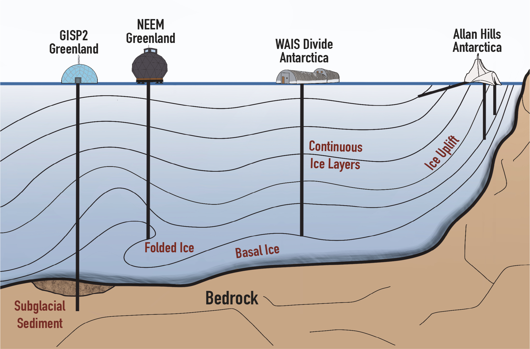
Discontinuous ice-core records, such as folded ice, uplifted ice, basal ice, subglacial materials, and ancient buried ice, offer snapshots of the past that can directly constrain ice-sheet configurations at timescales reaching into the Pliocene (5.3–2.6 Myr BP; Fig. 2). Ice-core records become discontinuous due to ice deformation, glacial erosion, or disconnection from the wider ice sheet. Ice flowing across its bed can fold, complicating simple stratigraphic interpretations of ice chronology. When the ice deformation history is disentangled, ice-core records can be tied to time periods older than the overlying ice. For example, the North Greenland Eemian Ice Drilling (NEEM) ice core from northeast Greenland contains folded ice from ~130 kyr BP during the warm Marine Isotope Stage 5e interglacial period, when sea level was 4–6 m higher than today (NEEM community members 2013). Older ice can be uplifted to the surface where ice flowing across the bed encounters mountainous topography, providing a snapshot of atmospheric composition older than continuous ice-core records provide. In the Transantarctic Mountains, uplifted ice in the Allan Hills (Figs. 1, 2) contains trapped atmospheric gasses from 1.0, 1.2, 2.4 Myr BP, and older, which is further back in time than any continuous ice-core record (Yan et al. 2019).
As drilling approaches the ice-sheet bed, ice cores can recover sediment-rich basal ice (Walcott et al. p. 114). Dating basal ice can provide a maximum age of ice cover. In the GRIP ice core, basal silty ice as old as 970 ± 140 kyr (Willerslev et al. 2007) has been found, suggesting that part of central Greenland remained ice-covered for the past ~1 Myr. Ice cores that recover subglacial sediment and bedrock from the bed of an ice sheet can be dated to directly constrain when a presently ice-covered landscape was deglaciated in the geologic past. In West Antarctica, radiocarbon analysis of subglacial lake-sediment core samples demonstrated that the grounding line in the Ross Sea retreated relative to its present position, and thus the West Antarctic Ice Sheet was smaller, in the Early Holocene (Venturelli et al. 2020). Dating of subglacial sediment from the Camp Century ice core in northwest Greenland (Christ et al. 2021) and subglacial bedrock from the GISP2 ice core (Schaefer et al. 2016) in central Greenland both require ice-free exposure at least once since ~1 Myr BP, implying that much of the GIS melted and contributed to sea-level rise within that time frame.
 |
|
Figure 2: Schematic of ice-core drilling settings that recover continuous and discontinuous ice-core records showing several examples from existing ice-core sites. |
In ice-free valleys in Antarctica, ancient ice from the Pliocene and possibly older periods remains frozen below a relatively thin layer of overlying glacial till (Bergelin et al. 2022). Although exceptionally challenging to date (Martin et al. p. 100), ice cores from debris-covered glaciers can provide snapshots far into the geologic past when atmospheric CO2 concentrations may have exceeded those observed today.
The future
The future of ice-core drilling aims to recover continuous ice-core records older than 800 kyr and discontinuous ice-core records that constrain past ice-sheet configurations. In Antarctica, several ongoing projects led by different international teams aim to recover the oldest ice to reveal the size and behavioral characteristics of the AIS during the Early Pleistocene (2.6–0.8 Myr BP). In Greenland, the GreenDrill project will drill several ice cores near the margin of the GIS to recover subglacial sediment and bedrock. These discontinuous records will resolve when and how often the GIS was smaller in the past than it is today. As Earth's ice sheets respond to continued climate warming, continuous and discontinuous ice-core records both offer important information on ice-sheet responses to past warming periods and contributions to sea-level rise.
affiliationS
1Rubenstein School of Environment & Natural Resources, University of Vermont, Burlington, USA
2Department of Soil, Water, and Climate, University of Minnesota, St. Paul, USA
3Department of Geological Sciences and Engineering, University of Nevada Reno, USA
contact
Andrew Christ: andrew.christ@uvm.edu
references
Bergelin M et al. (2022) Cryosphere 16: 2793-2817
Briner JP et al. (2020) Nature 586: 70-74
Christ AJ et al. (2021) Proc Natl Acad Sci USA 118: e2021442118
EPICA community members (2004) Nature 429: 623-628
Lambeck K et al. (2014) Proc Natl Acad Sci USA 111: 15,296-15,303
Miller KG et al. (2020) Sci Adv 6: 11
NEEM community members (2013) Nature 493: 489-494
Parrenin F et al. (2017) Cryosphere 11: 2427-2437
Schaefer JM et al. (2016) Nature 540: 252-255
Seierstad IK et al. (2014) Quat Sci Rev 106: 29-46
Venturelli RA et al. (2020) Geophys Res Lett 47: e2020GL088476
Vinther BM et al. (2009) Nature 461: 385-388
WAIS Divide Project Members (2013) Nature 500: 440-444
Caleb K. Walcott![]() 1, E. Erwin2,3 and B.H. Hills4,5
1, E. Erwin2,3 and B.H. Hills4,5
We describe the ice, water, bedrock, and sediments found at the ice–bed interface during ice-core drilling and the insights into paleoclimate, ice dynamics, ice-sheet history, and geologic history that they provide.
Ice cores have commonly been collected to develop continuous paleoclimate records and to analyze atmospheric gases in the ice column. Recently, scientists have recognized that materials at the ice–bed interface yield invaluable information about Earth and ice-sheet history on longer timescales. Research is now being devoted to finding million-year-old-plus ice at the bottom of ice sheets, investigating basal thermal regimes, and analyzing sub-ice sediment and bedrock samples collected during drilling campaigns.
Ice at the bottom of ice sheets
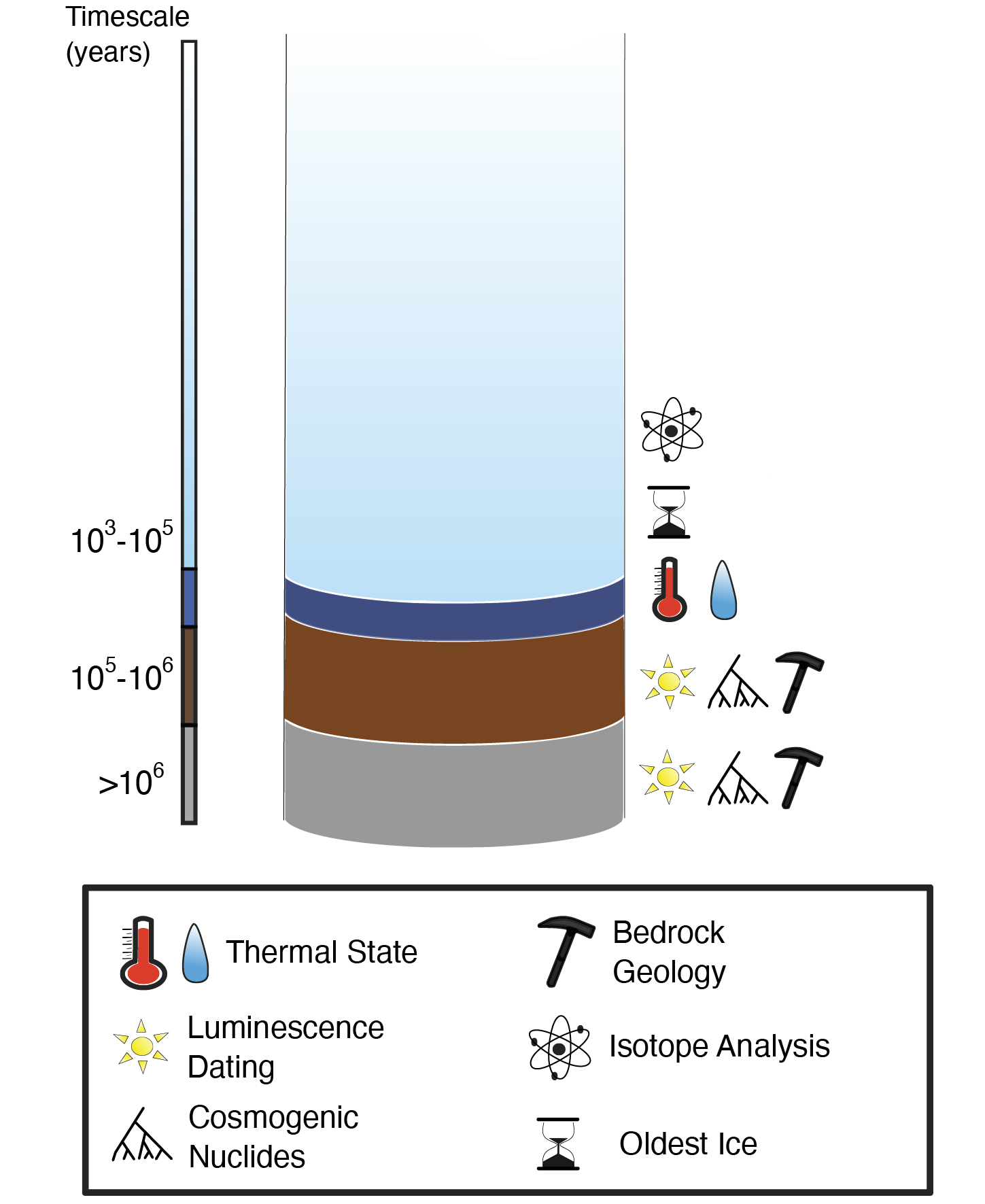
Paleoclimate signals preserved in ice cores are revealed, for example, through the analysis of isotopes (Fig. 1), which serve as fingerprints of climate (Wendt et al. p. 102). These signals are captured by yearly surface accumulation, layering younger ice on top of older ice. Under typical conditions, the oldest ice is found at the bottom of ice sheets; however, areas of high ablation can bring this old ice to the surface. While ice has covered parts of East Antarctica for millions of years and central parts of Greenland for ~1 million years, the longest continuous ice-core records extend to only ~800,000 years in Antarctica (Jouzel et al. 2007), and ~128,000 years in Greenland (NEEM community members 2013). Recovering ice-core samples that extend the current climate record to over 1 million years would provide insights into climate change across the Mid-Pleistocene Transition (~1.2 to 0.9 million years ago), a key climate period marked by the changing cyclicity of glacial cycles (Dahl-Jensen 2018). To produce an uninterrupted and coherent record of climate across this transition, continuous stratigraphy is needed; however, discontinuous "snapshots" are also valuable.
 |
|
Figure 1: Schematic of a deep ice-core sample, including the subglacial melt (dark blue), sediments (brown), and bedrock (gray). Icons indicate the scientific approaches relevant to deep ice and subglacial materials. |
Ice flow over rough bed topography and heat from the Earth below can, over thousands of years, disrupt the stratigraphy of the ice column, complicating the age–depth relationship (Martin et al. p. 100). Disturbed chronology is present in long ice cores recovered from Greenland, where ice has folded or overturned near the bed (Chappellaz et al. 1997). In Antarctica, the combination of complex bed topography and ice flow has caused discontinuous layers of old ice to be thrust towards relatively shallow depths, with ~4.3–5.1-million-year-old ice outcropping in the Transantarctic Mountains (Bergelin et al. 2022). Ice cores with disturbed chronologies, while valuable, inhibit the development of continuous paleoclimate records. Efforts are now focused on using ground-penetrating and phase-sensitive radar to examine internal ice-sheet stratigraphy to select ice-core sites that are most likely to have an intact chronology that extends to over 1 million years in Antarctica.
Water at the bed
Preservation of the oldest ice at the bottom of ice sheets depends largely on the thermal state of the ice–bed interface (the basal boundary). Ice sheets act as an insulator between cold air temperatures at the surface and the relatively warm bed, which is heated by geothermal sources from the solid Earth. Thicker ice is a better insulator and thus generally leads to a warmer bed, though the melting point decreases with thicker ice and correspondingly increased pressure. At the West Antarctic Ice Sheet divide, for example, the pressure melting point is estimated to be -2.3ºC beneath ~3480 m of ice (Talalay et al. 2020). If the ice is sufficiently warm at the basal boundary, it melts, destroying climate records contained within it, and creating a layer of water at the bed. Water at the bed can also be sourced from ice that melts at the surface and reaches the bed through crevasses and moulins; this and basal meltwater affect ice dynamics, influencing the complexity of ice flow at an ice-core drilling location.
Scientists thus commonly survey prospective ice-core sites using geophysical tools to determine the frozen/thawed state at the basal boundary. Both radar and seismic reflections are stronger over an ice–water interface, so parts of the bed with particularly strong reflections can be specifically targeted (Christianson et al. 2012) or avoided (Fudge et al. 2022) depending on the drilling objective. Determining whether the bed is completely frozen, however, can be difficult using geophysical tools because basal melting can occur even where water is not observed. Instead, frozen beds can be determined by interpreting internal stratigraphy or repeat radar measurement to infer whether the ice is moving only by deformation or also by sliding, the latter of which suggests water may be present at the bed (Martin et al. 2009). Comprehensive studies of the Greenland Ice Sheet show that the basal thermal state is mostly thawed in highly dynamic areas, such as the Northeast Greenland Ice Stream drainage, and mostly frozen in the slower-flowing regions (Fig 2c; MacGregor et al. 2022). The basal thermal state of the Antarctic Ice Sheet is less well constrained at the continental scale, but hundreds of subglacial lakes have been identified, indicating areas of thawed bed (Wright and Siegert 2012).
Sub-glacial bedrock and sediments
Bedrock and sediments beneath ice sheets contain valuable information on subglacial geology and ice-sheet history. Ice sheets cover most of Greenland and Antarctica, and thus, little is known about the types of rock that make up these landmasses (e.g. Dawes 2009). Some ice-core drilling campaigns have collected bedrock from beneath the ice sheets, giving geologists the rare opportunity to study the rocks underneath the ice (e.g. Gow and Meese 1996). Sediment is transported by flowing ice, like a conveyor belt, bringing material from the interior of ice sheets to the outer fringes. Analysis of these sediments and ice-flow patterns provides information on the bedrock geology from more central—and hard to access—sections of ice sheets (Fountain et al. 1981).
 |
|
Figure 2: (A) Basal ice from the Byrd ice core, Antarctica (Gow and Meese 1996); (B) Bedrock core from GISP2, Greenland (Image credit: Geoffrey Hargreaves); and (C) A Greenland-scale product of inferred basal thermal state (blue is frozen, red is melting, gray is not confidently constrained; MacGregor et al. 2022). |
Sub-ice bedrock and sediments can also reveal information about ice-sheet history, including when areas were ice-free and the duration of ice cover. These ice-sheet histories are valuable for paleoclimate modeling and for predicting how the Greenland and Antarctic ice sheets will respond to future warming and contribute to sea-level rise (Christ et al. p. 116). To determine histories of past ice-sheet change, glacial geologists use two different methods: cosmogenic nuclide dating and luminescence dating (Fig. 1). Combined, these tools can be used to elucidate both how long areas beneath an ice core have been ice-free or ice-covered in the past, and potentially when these ice-free/ice-cover events occurred, thus allowing for assessments of ice-sheet stability over the Quaternary. While previous studies investigating ice-sheet history relied on legacy materials collected during previous ice-core campaigns (Christ et al. 2021; Schaefer et al. 2016), new projects, such as the EXPROBE-WAIS and Thwaites campaigns in Antarctica and GreenDrill in Greenland, specifically target areas for drilling to assess ice-sheet stability rather than develop direct paleoclimate records (i.e. prioritizing bedrock and sediments over a simple ice stratigraphy; Briner et al. 2022). In the United States, these projects are aided by the development of new US Ice Core Drilling Program drills that can quickly drill through the thin parts of ice sheets and collect basal ice and sub-ice materials. This new work is paving the way to investigate ice-sheet histories via bed samples from multiple key locations across the Antarctic and Greenland ice sheets.
Conclusions
Scientists now are increasingly able to investigate the ice–bed interface and the valuable information contained therein. Basal ice that is older than the current records in Greenland and Antarctica would extend terrestrial records of past climate. Knowledge of the basal thermal state is valuable for selecting ice-core sites. Investigating sub-ice sediment and bedrock yields insights into the bedrock geology and ice-sheet history. Several new projects are now focusing on collecting samples from the ice–bed interface to provide more information on this key transition zone. For example, the COLDEX (coldex.org) program is trying to locate the oldest ice on Earth today in Antarctica, while the Pirritt Hills, Thwaites, and GreenDrill projects are focusing on collecting subglacial bedrock and/or sediment to constrain ice-sheet histories in Antarctica and Greenland. These new advances in accessing, processing, and understanding data from the ice–bed interface allow for synergistic science capable of using everything collected in an ice-core campaign, from the surface firn (McCrimmon et al. p. 112) to the bedrock below the ice.
affiliations
1Department of Geology, University at Buffalo, NY, USA
2School of Earth and Climate Sciences, University of Maine, Orono, USA
3Cold Regions Research and Engineering Laboratory, Hanover, NH, USA
4Department of Earth and Space Sciences, University of Washington, Seattle, USA
5Applied Physics Laboratory, University of Washington, Seattle, USA
contact
Caleb Walcott: ckwalcot@buffalo.edu
references
Bergelin M et al. (2022) Cryosphere 16: 2793-2817
Briner JP et al. (2022) EGUsphere, doi:10.5194/egusphere-2022-264
Chappellaz J et al. (1997) J Geophys Res Oceans 102: 26547-26557
Christ AJ et al. (2021) Proc Natl Acad Sci USA 118: e2021442118
Christianson K et al. (2012) Earth Planet Sci Lett 331-332: 237-245
Dahl-Jensen D (2018) Nature Geosci 11: 703-704
Dawes PR (2009) GEUS Bull 17: 57-60
Fountain J et al. (1981) J Glaciol 95: 193-197
Fudge TJ et al. (2022) J Glaciol, doi:10.1017/jog.2022.80
Gow AJ, Meese DA (1996) Ann Glaciol 22: 134-140
Jouzel J et al. (2007) Science 317: 793-796
MacGregor JA et al. (2022) Cryosphere 16: 3033-3049
Martín C et al. (2009) J Geophys Res Earth Surf 114: F02006
NEEM community members (2013) Nature 493: 489-494
Schaefer JM et al. (2016) Nature 540: 252-255