PAGES Magazine articles
M. Chadwick1, K.E. Kohfeld2, H. Bostock3, X. Crosta4, A. Leventer5 and K. Meissner6
Antarctic sea ice plays several crucial roles within the Earth system. The sea-ice seasonal cycle influences atmospheric dynamics (heat and air-sea gas exchanges; Rysgaard et al. 2011) and affects the circulation of heat, salt, and nutrients within the ocean (Maksym 2019). On glacial–interglacial timescales, sea ice has been proposed as an important player in modulating changes in atmospheric carbon dioxide concentration (Kohfeld and Chase 2017). Our understanding of the role of sea ice within this system is dependent on our ability to reconstruct and model past sea-ice changes, as well as to reconstruct and model complementary changes within the Earth and climate system.
The Cycles of Sea-Ice Dynamics in the Earth System (C-SIDE; pastglobalchanges.org/c-side) working group was established in 2018 to synthesize existing sea-ice records from the Southern Ocean over the past 130,000 years. The main objective of C-SIDE is to better understand how changes in sea ice were related to other important oceanic processes, and to examine more closely how sea ice is simulated in Earth system model simulations of the last glacial period. Our choice of this timescale was selected so that we could evaluate sea-ice dynamics during previous warm periods (e.g. the Last Interglacial Period when Antarctica was 2ºC warmer than today), warming glacial-to-interglacial transitions, and the major cooling periods of glacial inception, during which ocean carbon uptake was substantial.
 |
|
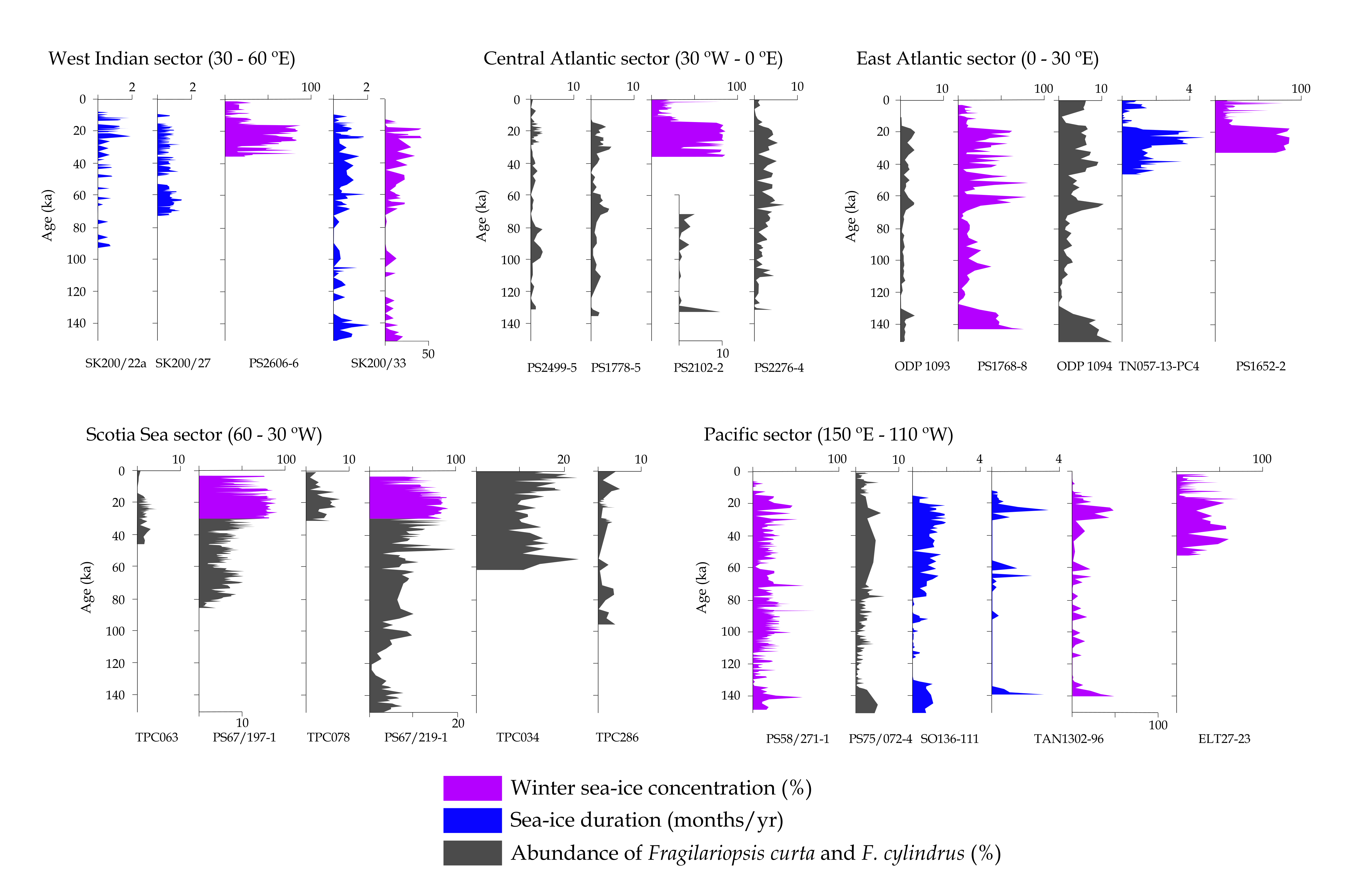
Figure 1: Compilation of Southern Ocean sea-ice records for the last 150,000 years from 24 core sites. Sea-ice records are grouped by region of the Southern Ocean and colored according to sea-ice reconstruction type. This figure is adapted from Chadwick et al. (2022b). |
During our first three years, the C-SIDE group held two workshops with the sea-ice community, which helped us to establish research priorities and outline the scope of our efforts. We assembled a comprehensive inventory of Southern Ocean sea-ice records covering at least a part of the time interval between 130,000 years ago and the Holocene. From this inventory, we identified 24 sites with high-resolution and long-duration sea-ice records for the last glacial-interglacial cycle (Fig. 1; Chadwick et al. 2022b). These data have been submitted to the PANGAEA database, and the paper has been submitted as part of a special issue that we organized for Climate of the Past entitled "Reconstructing Southern Ocean sea-ice dynamics on glacial-to-historical timescales". This special issue will be accepting topical submissions until December 2022. In addition to the sea-ice compilation, this special issue includes articles presenting new Southern Ocean sea-ice reconstructions (Chadwick et al. 2022a; Jones et al. 2022), as well as articles discussing developments in novel Antarctic sea-ice proxies (Lamping et al. 2021; McClymont et al. 2022; Vorrath et al. 2020). It also contains articles evaluating the processes controlling sea-ice distribution and deep-ocean circulation in simulations of the last glacial maximum, using climate models from the Paleoclimate Modelling Intercomparison Project PMIP3 and PMIP4, and iLOVECLIM (Lhardy et al. 2021; Green et al. 2020).
The second phase of the working group is already brimming with activities. Two review papers are nearing completion and will address, firstly, the use of a range of proxies for reconstructing sea ice during the last 130,000 years and, secondly, the current state of our understanding of how sea ice is linked with atmospheric, oceanic, land ice, and biogeochemical processes on glacial–interglacial timescales. With the help of funds from Simon Fraser University (SFU) and the Canadian Mitacs program, C-SIDE members will be hosting three early-career researchers at SFU to bring together complementary datasets (sea-surface and subsurface temperature records reconstructed using radiolarian proxies) to examine temporal relationships between sea-ice changes and ocean temperature and water mass behavior in the Southern Ocean. C-SIDE is also collaborating with the leaders of the Arctic Cryosphere Change and Coastal Marine Ecosystems (ACME; pastglobalchanges.org/acme) working group to produce a PAGES Magazine issue on sea-ice changes at both poles to be published in the second half of 2022. Finally, as international travel possibilities re-emerge, the C-SIDE steering committee is looking into opportunities to reschedule our third, postponed, workshop, to focus our ongoing efforts within the global sea-ice and PAGES communities.
affiliationS
1British Antarctic Survey, Cambridge, UK
2School of Resource and Environmental Management and School of Environmental Science, Simon Fraser University, Burnaby, BC, Canada
3School of Earth and Environmental Sciences, University of Queensland, Brisbane, Australia
4University of Bordeaux, France
5Department of Geology, Colgate University, Hamilton, NY, USA
6Climate Change Research Centre, University of New South Wales, Sydney, Australia
contact
Karen Kohfeld: kohfeld sfu.ca
references
Chadwick M et al. (2022a) Clim Past 18: 129-146
Chadwick M et al. (2022b) Clim Past Discuss, doi:10.5194/cp-2022-15
Green RA et al. (2020) Clim Past Discuss, doi:10.5194/cp-2020-155
Jones J et al. (2022) Clim Past 18: 465-482
Kohfeld KE, Chase Z (2017) Earth Planet Sci Lett 472: 206-215
Lamping N et al. (2021) Clim Past 17: 2305-2326
Lhardy F et al. (2021) Clim Past 17: 1139-1159
Maksym T (2019) Ann Rev Mar Sci 11: 187-213
McClymont EL et al. (2022) Clim Past 18: 381-403
Rysgaard S et al. (2011) Tellus B Chem Phys Meteorol 63: 823-830
PAGES 2k Network coordinators
The PAGES 2k Network (pastglobalchanges.org/2k), founded in 2008, is one of the longest-running PAGES working groups. It has consistently achieved a high degree of community engagement and delivered significant datasets and publications. These have fundamentally improved our understanding of global climate changes through the Common Era. The 2k reconstructions of global temperature variability were featured in Figure 1 of the Summary for Policymakers of the IPCC’s Working Group I contribution to the Sixth Assessment Report (AR6; IPCC 2021).
Along with temperature, hydroclimate is an important way in which societies experience climate variability. However, AR6 highlighted notable uncertainty in historical (Fig. 1) and projected hydroclimate changes, and low agreement on the regional scale (Fig. 1). Constraining the models used to simulate future changes, and using these same models to provide dynamical understanding of past hydroclimate, are therefore the main foci of the new (4th) phase of the 2k Network.
 |
|
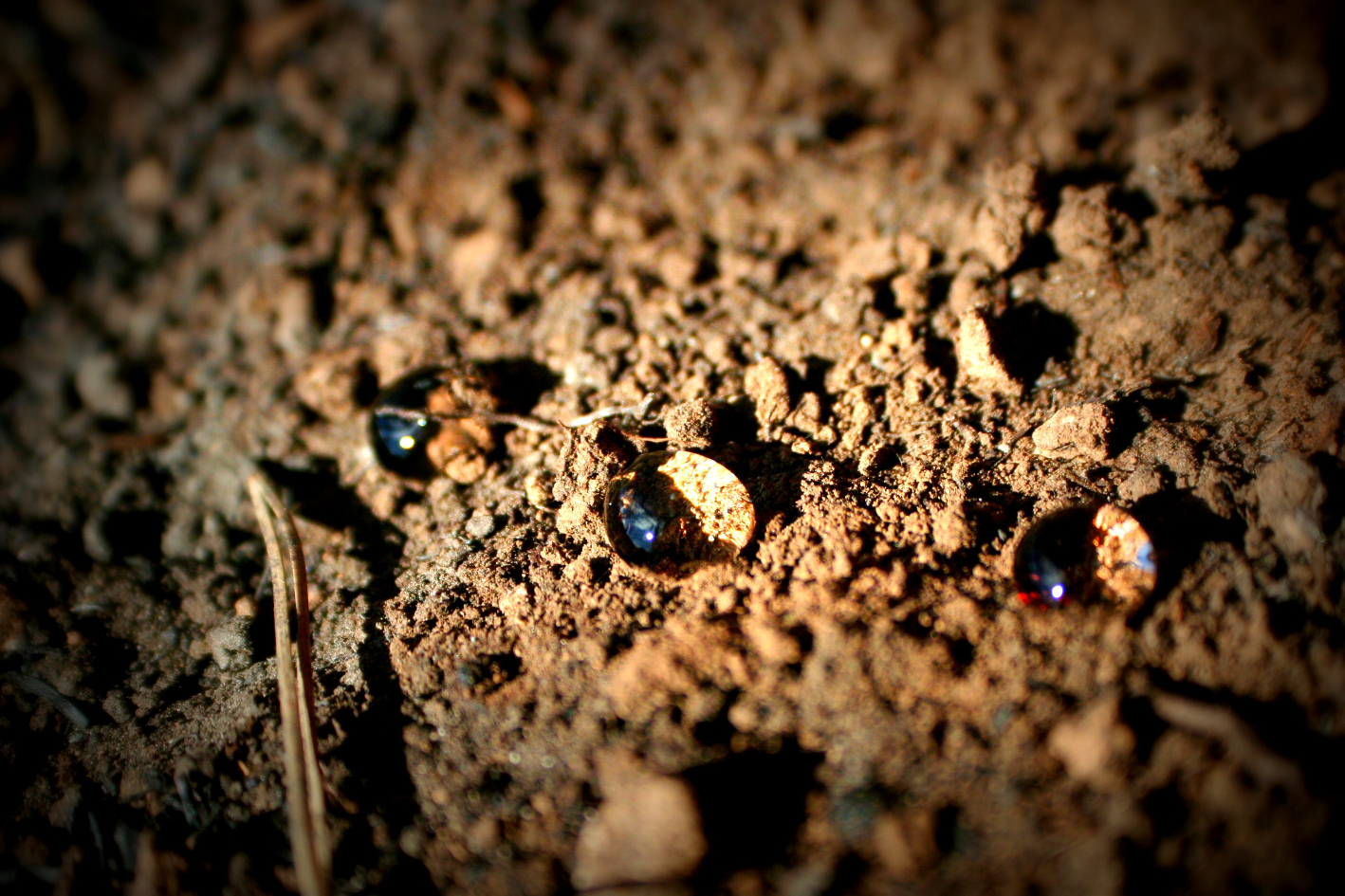
Figure 1: This photograph was taken a few days after a forest fire in a pine-forested area near Montellano (SW Spain) (photo credit: Antonio Jordán, University of Seville, Spain; imaggeo.egu.eu/view/1327). License: CC BY-NC-SA 3.0 (creativecommons.org/licenses/by-nc-sa/3.0). |
Phase 2 of the 2k Network (2014–2016) provided recommendations for incorporating paleoenvironmental data and climate model simulations to understand hydroclimate (PAGES Hydro2k Consortium 2017). Building on this, Phase 3 (2017–2021) supported the development of new databases, including:
- Iso2k (pastglobalchanges.org/iso2k), a compilation of proxy records preserving information of hydroclimate changes via their imprint in the stable isotopic composition of water;
- CoralHydro2k (pastglobalchanges.org/coralhydro2k), a collection of paired coral δ18O and Sr/Ca records that can be used to investigate temperature and hydrologic variability in the tropical to subtropical oceans; and
- CLIVASH2k (pastglobalchanges.org/clivash2k), a collection of ice core proxies to understand southern hemispheric climate modes.
These 2k Network products, and other data compilations, contain extensive information about hydroclimate-relevant variables (e.g. precipitation amount, the ratio of precipitation to evaporation, atmospheric circulation patterns, drought, floods, and seawater characteristics). Hydroclimate changes are inherently more complex than temperature changes, which motivates the science goals of the new phase.
Scientific goals
Phase 4 of the 2k Network builds on previous and ongoing projects, as well as modeling and data synthesis and assimilation activities within the wider paleoclimate community, to better understand Common Era hydroclimate by working on the following objectives:
- Leverage paleoclimate proxy information contained in ongoing and existing databases (e.g. Iso2k, CoralHydro2k, CLIVASH2k, drought atlases, Neotoma, SISAL), and datasets not yet collated in databases, to understand spatial and temporal hydroclimate variability. This includes developing a better understanding of uncertainties.
- Use the hydroclimate proxy and reconstruction data to evaluate Earth system models, whilst using these models to inform process-level understanding of Common Era hydroclimate. This includes close integration with the modeling communities.
- Ensure that 2k Network data products are available for ongoing use through dedicated tools and practices to maximize their longevity and interoperability.
- Work with policy advisors to ensure that 2k Network scientific findings will be used to inform policy outcomes.
Invitation to engage in Phase 4 activities
To achieve our aims, the coordinators will facilitate interaction among researchers. This includes liaising with ongoing 2k research efforts as well as partner research groups and external stakeholders, e.g. CVAS (pastglobalchanges.org/cvas), SISAL (pastglobalchanges.org/sisal), Floods (pastglobalchanges.org/floods), PMIP-Past2k (pmip.lsce.ipsl.fr/working_groups/Past2K), LinkedEarth (linked.earth), and WCRP Lighthouse Activities (wcrp-climate.org/lha-overview). We are particularly interested in participation from the modeling community to ensure that we collate hydroclimate proxy data that enables meaningful comparison with climate model outputs. We invite researchers that participate in these groups to contact us if they would like to be a formal liaison.
Interactions facilitated by the 2k Network will include workshops, a continuation of the successful online 2k seminar series, and engagement with early-career researchers (ECR). The first workshop will be held as a splinter meeting of the PAGES OSM (May 2022). This workshop will scope what steps are required to mine hydroclimate-relevant information from existing databases, identify data that are not yet in databases, and connect to data assimilation and climate simulation efforts. A second workshop will focus on data–model integration, including proxy system model steps, and a third workshop will develop tools to ease data re-use and interoperability. The PAGES 2k coordinators will apply for a PAGES Data Stewardship Scholarship (following up on three successful 2k Network-related proposals in 2021) and additional funding. We invite researchers to get in touch if interested in giving a seminar (or with topics that you would be interested in hearing about!), to participate in database compilation, and if specific workshop themes are of interest. We also aim to enable discussion on data accessibility and software tools through dedicated projects with the ECR and LinkedEarth communities.
To succeed in our plans, the 2k Network relies on the engagement of the wider community. We are excited to invite you to our first Phase 4 virtual workshop to be organized online at the PAGES Open Science Meeting (pages-osm.org) in May 2022.
affiliationS
A. Atwood (Florida State University, Tallahassee, FL, USA)
O. Bothe (Helmholtz-Zentrum Hereon, Geesthacht, Germany)
S. Eggleston (Past Global Changes, International Project Office, Bern, Switzerland)
G. Falster (Australian National University, Research School of Earth Sciences, Canberra, Australia)
B.J. Henley (Monash University, Clayton, Australia)
M. Jones (University of Nottingham, UK)
L. Jonkers (MARUM, University of Bremen, Germany)
N. Kaushal (ETH Zürich, Switzerland)
B. Martrat (Institute of Environmental Assessment and Water Research (IDAEA-CSIC), Barcelona, Spain)
H.V. McGregor (University of Wollongong, Australia)
A. Orsi (University of British Columbia, Vancouver, Canada)
S.J. Phipps (Ikigai Research, Hobart, Australia)
H. Sayani (SLR International Consulting, Atlanta, GA, USA)
contact
Nikita Kaushal: nikitageologistgmail.com
references
Kayla M. de Freitas1,2, G.A. Winter3, T. A. Kennedy3,4, A. Johnny3,4 and J. Mistry1,2
Indigenous peoples' contribution to science is increasingly recognized in academia. Cross-disciplinary approaches in past environmental change research provides a holistic picture of climate and justice issues. There needs to be ethical engagement of Indigenous peoples in research, with two-way benefits.
Indigenous peoples' contribution to scientific research is increasingly recognized in academia, policy, climate change research, and conservation management (Delgado et al. 2017; Hill et al. 2020). Past environmental change research combined with traditional knowledge can provide innovative perspectives to conservation, climate impact and justice issues (Lyver et al. 2015). By working with Indigenous peoples, paleo-ecological scientists can enhance their data collection and analysis, but also contribute results that support Indigenous rights and management decisions. To meaningfully engage with Indigenous peoples, academia needs to encourage approaches that engage with diverse knowledge systems.
Here we outline the increasing recognition of Indigenous people's contributions to academia. This is followed by the ethics of engagement recommended by Indigenous researchers themselves, and finally we examine the "two-way" relationship between "researcher" and "participant" covering issues such as data ownership and benefits, and its relevance to paleoecological researchers.
Indigenous contribution to scientific research, environmental policy, and management
Current scientific research is rooted in curiosity and the need to find innovative solutions in today's rapidly changing climatic, economic, environmental, and ecological circumstances. Scientific research, historically and currently, relies on Indigenous knowledge in many aspects of fieldwork and research. This contribution and collaboration has not always been accredited, but, today there is increasing recognition of Indigenous knowledge in academia and among practitioners who work with diverse knowledge systems (Delgado et al. 2017). This recognition is across fields in different disciplines and includes, but is not limited to: climate change adaptation and risk reduction (Mercer et al. 2010), biodiversity conservation (Robinson and Wallington 2012), and environmental policy and landscape management (Milgin et al. 2000; Hill et al. 2020).
Top-down environmental policies often clash with realities on the ground; for example, in Canaima National Park, Venezuela, fire suppression policies led to increased occurrences of destructive fires and marginalization of the Indigenous Pemon land management techniques using patch burning in a flammable landscape (Bilbao et al. 2010). Thus, there is an increasing need to support the development of appropriate policies that integrate local governance systems and ways of making decisions about environmental management (Delgado-Serrano et al. 2017).
There are tensions surrounding the engagement of Indigenous peoples in scientific research; namely, these tensions surround issues of ethical engagement, data sharing, acknowledgement of contribution, and benefits for Indigenous peoples in providing support to science.
 |
|
Figure 1: Conscious research ensures that the process is not "academic mining", but respectful and active engagement. By ethically engaging with Indigenous peoples, researchers in paleoecology, and related fields, can enhance scientific research by working with diverse systems and considering innovative approaches to tackling today's environmental issues, but also contribute to Indigenous rights and self-determination (photo credit: Angelbert Johnny/South Rupununi District Council). |
Ethics of approaching and engaging Indigenous peoples in research
Engagement with Indigenous peoples can lead to a more holistic understanding of land-use practices, but also creates a risk for perpetuating colonial approaches. Merging paleoecology, archaeology, and oral histories can support Indigenous land struggles (Oetelaar 2002; Welch 2020). Paleoecology provides past environmental data about land that people occupy and use, which can contribute to decisions regarding land management for the future. These types of data can strengthen claims to land, showing historical use of customary lands, and can aid in presenting a case to the government and relevant authorities, but challenges exist regarding how this can be done in an ethical manner (Chilisa 2020). Indigenous representatives and allies have raised questions about data governance and advocated for research that benefits Indigenous agendas and needs (Tsosie et al. 2021). Some researchers have diversified their methodologies, using more participatory approaches such as participatory video, where participants in research create their own films about the issues or topics they are concerned with as part of a collaborative approach with the researcher. These new approaches have the potential to transform collaboration, put the research process more in the hands of Indigenous peoples, and be used to assert identity and raise awareness on issues such as land rights (Mistry et al. 2015).
Some Indigenous representative organizations, like the South Rupununi District Council (SRDC) in Guyana, have created internal guidelines on how researchers, and others seeking to work with Indigenous communities, should ethically engage. Key messages include the need for contemporary research with Indigenous peoples to engage on principles of trust and relationship building, reciprocity, and clarity on what results from the research will be used, and who will be acknowledged as owners of the final product. A local grassroots conservation organization, the South Rupununi Conservation Society's (SRCS) approach incorporates local design and initiatives in planning for conservation activities. Community Researcher Rangers are trained to collect data in support of their conservation activities on their customary lands, help design research approaches, and identify what key areas the SRCS should focus on.
|
Before the research
During the research
After the research
|
|
Table 1: Steps to encourage ethical engagement |
Steps to encourage ethical engagement with Indigenous peoples
For the steps outlined in Table 1, the principles of Free, Prior, and Informed Consent (FPIC) should continuously be employed throughout engagement with Indigenous peoples (see ohchr.org/en/indigenous-peoples for more information).
Table 1 summarizes a guide for ethically engaging with Indigenous peoples, one of the outcomes of a webinar promoted by the PAGES DiverseK working group and the Leverhulme Wildfires Centre (pastglobalchanges.org/calendar/128488).
A two-way relationship: Data ownership and benefit sharing
Kwaymullina (2016) states that there are three "thresholds" that non-Indigenous scholars should take into consideration when thinking about working with Indigenous peoples: if the research should be conducted, power dynamics and impact of the fieldwork, and the ethical principles, such as FPIC and intellectual property rights, used in research. Researchers who benefit from Indigenous knowledge and experience, or rely on Indigenous peoples' support in data collection, have a responsibility to ensure ethical engagement during research, appropriate methodologies to approach research with Indigenous peoples, and clarity on data ownership and who benefits from what aspects of the research (Tsosie et al. 2021). Indigenous peoples have historically been misrepresented in research, and steps to correct this have been taken in the form of acknowledgement or co-authorship on manuscripts (Smylie et al. 2020).
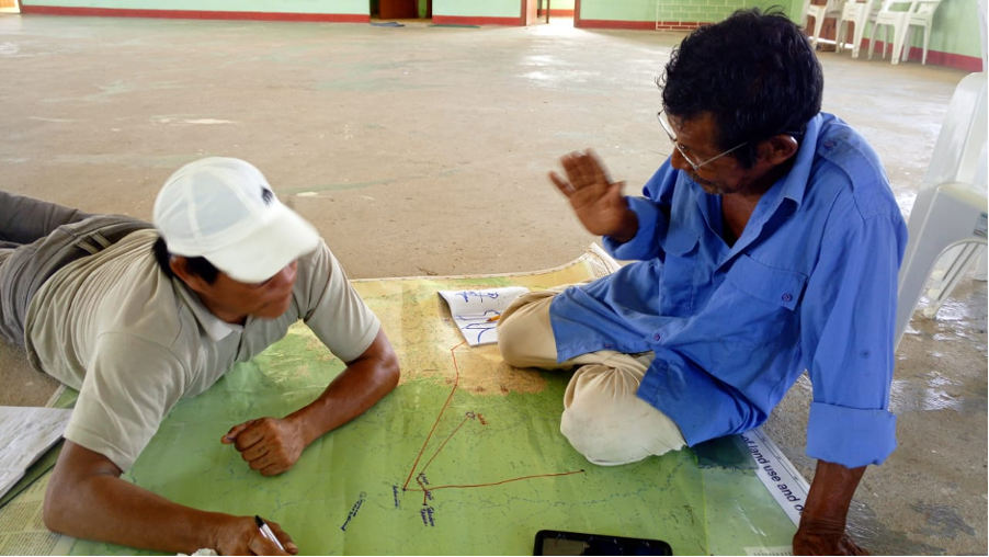
The co-production of knowledge through research with Indigenous peoples should be based on trust and agreed reciprocity (Milgin et al. 2000; Carroll et al. 2020). This is a process that takes time, and researchers' expectations for timelines must be adapted to allow for authentic engagement with Indigenous communities. Researchers often have their own aims to achieve and should consider what is meant by a "two-way" relationship. Thus, the expectations for researchers working with diverse knowledge systems within academia should be adjusted to reflect this. Paleoecologists and other scientists can strive to engage in research that builds local capacity, encourages local governance, contributes data towards Indigenous peoples' needs, and create a space for local decisions. For example, shown in Figure 1, within the SRDC there are people who create maps for their own territory that are used in land-rights discussions or management planning as a product of engaging in previous research that promoted skills and knowledge exchange.
Acknowledgements
This contribution reflects discussions during a PAGES DiverseK webinar presentation in September 2021 (pastglobalchanges.org/calendar/128488) by three Indigenous researchers from the South Rupununi, Guyana (co-authors of this article: GAW, TAK, and AJ), who spoke of their experiences working with scientific researchers. The webinar sought to create a space for interaction between Indigenous researchers from the South Rupununi District Council (SRDC) the South Rupununi Conservation Society (SRCS) and other scientific researchers. In particular, the webinar targeted scientists in the field of paleoecology interested in undertaking work with Indigenous peoples. Watch the recording at vimeo.com/662695164.
affiliations
1Department of Geography, Royal Holloway University of London, UK
2Leverhulme Centre for Wildfires, Environment and Society, London, UK
3South Rupununi District Council, Region 9, Guyana
4South Rupununi Conservation Society, Region 9, Guyana
contact
Kayla M. de Freitas: kayla.defreitas.2019live.rhul.ac.uk
references
Bilbao BA et al. (2010) Hum Ecol 38: 663-673
Carroll SR et al. (2020) Data Sci J 19: 1-12
Chilisa B (2020) Indigenous Research Methodologies. SAGE Publications Inc, 392 pp
Delgado-Serrano ME et al. (2017) Ecol Soc 22: 4
Hill R et al. (2020) Curr Opin Environ Sustain 43: 8-20
Hogg ER, Welch JR (2020) J Soc Archaeol 20: 214-241
Kwaymullina A (2016) Alternative 12: 437-449
Lyver PO'B et al. (2015) Hum Ecol 43: 681-695
Mercer J et al. (2010) Disasters 34: 214-239
Milgin A et al. (2020) People Nat 2: 1210-1212
Mistry J et al. (2015) Cult Geogr 22: 689-712
Oetelaar GA (2002) Can J Archaeol 26: 217-220
Robinson C, Wallington T (2012) Ecol Soc 17: 16
Kelsey Copes-Gerbitz![]() 1, W. Spearing2 and L.D. Daniels
1, W. Spearing2 and L.D. Daniels![]() 1
1
Integrating Indigenous knowledge into tree-ring fire histories without meaningful collaboration with Indigenous peoples is an ongoing form of colonization. Here, we describe how our collaborative tree-ring research process led to more accurate and ethical research expectations, questions, methods, and interpretations.
Tree-rings are valuable records of disturbance regimes that can guide landscape management by providing evidence of historical fire frequency, severity, extent, and drivers (Daniels et al. 2017). Tree-rings are often combined with other long-term proxy data (e.g. paleoecological records) for a more holistic understanding of historical fire dynamics (Swetnam et al. 1999). Increasingly, non-Indigenous natural scientists (including dendrochronologists) are also interested in incorporating Indigenous knowledge to help inform our understanding of historical fire dynamics (Guiterman et al. 2019; Larson et al. 2020; Roos et al. 2021). However, treating Indigenous knowledge as just another proxy record that must be validated by natural science overlooks the complex dimensions of Indigenous fire stewardship, such as spirituality, respect, and reciprocity (Lake and Christianson 2019). Furthermore, if not undertaken in collaboration with Indigenous peoples, tree-ring (and other paleoecological) research can perpetuate the power imbalances inherent in colonization by excluding Indigenous peoples from interpreting and managing landscapes (Mistry and Berardi 2016; Fernández-Llamazares et al. 2021). Here, we describe the evolution of our collaborative tree-ring research in British Columbia (BC), Canada, since 2016 as an archaeologist (WS) for the T'exelc (Williams Lake First Nation, an Indigenous community*) and as non-Indigenous natural scientists (KCG and LDD). This collaborative research took place at Ne Sextsine, a 6000-hectare forest in the T'exelc traditional territory that has been continuously stewarded since time immemorial.
Building a collaborative research context
Across BC, Indigenous fire stewardship was, and continues to be, spatiotemporally complex (Lake and Christianson 2019; Lewis et al. 2018). Nevertheless, over 100 years of colonial fire governance enacted on unceded Indigenous territories has excluded Indigenous peoples from decision-making, despite being strongly connected to place and invested in the future (Lake and Christianson 2019; Hoffman et al. accepted manuscript; Copes-Gerbitz et al. accepted manuscript). The legal implementation of the United Nations Declaration on the Rights of Indigenous Peoples in Canada and BC, however, provides an obligation to uphold Indigenous rights and advance reconciliation (Wong et al. 2020). Thus, as researchers in BC (KCG and LDD), it is our ethical duty to undertake collaborative tree-ring research with Indigenous peoples.
Our collaboration began on invitation from a non-Indigenous gatekeeper who is a well-respected member of the local community and undertakes forest management guided by Indigenous and natural science. This gatekeeper was familiar with our tree-ring fire histories and was entrusted by the T'exelc to manage Ne Sextsine. In 2016, this gatekeeper introduced us (KCG and LDD) to the elected Chief and Council, who then introduced us to members of the Natural Resources Department, including an archaeologist (WS), who became a key collaborator, and the Elder Council. All groups expressed interest in building a research collaboration. Through eight community meetings and six months spent in the community over the next three years (by KCG), we co-developed our research questions guided by the interests of Elders and forest managers – including, but not limited to, how Indigenous land and fire stewardship shaped the historical landscape through time and how this stewardship can inform future management. Our agreed research practices, including guiding questions, data ownership and confidentiality, and expectations of researchers (such as publications), were outlined in a signed Memorandum of Understanding between the elected T'exelc Chief, the Ne Sextsine forest manager, and the researchers. At the time, this level of engagement was beyond the requirements of our university's research ethics process, but we felt it was imperative for maintaining reciprocal trust and respect. Today, researchers at the University of British Columbia are required to formalize legally binding agreements with Indigenous community partners before collaborative research can begin.
 |
|
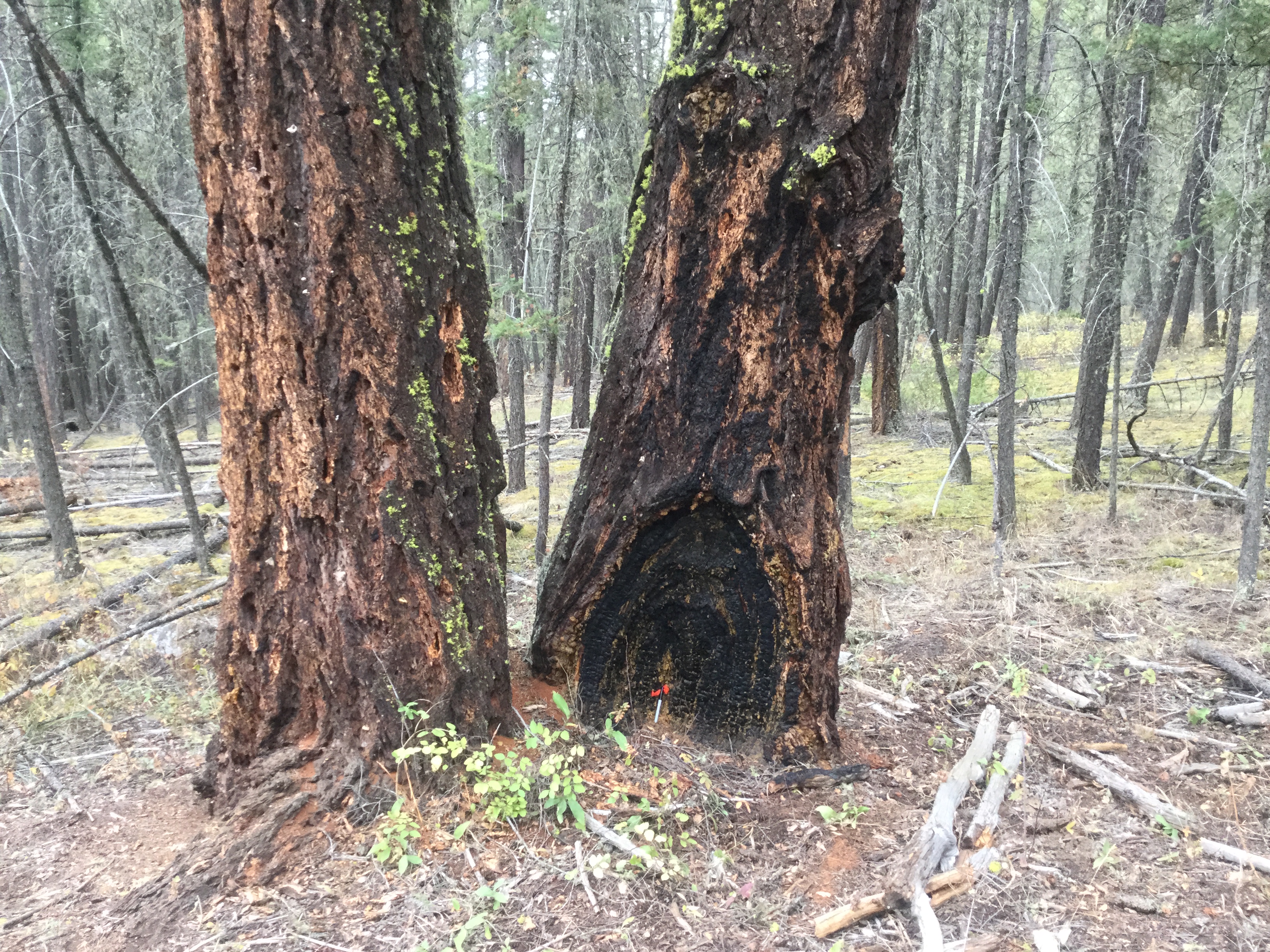
Figure 1: Fire-scarred tree with at least 12 visible fire scars at Ne Sextsine. Although this tree could have been "convenience" sampled, we intentionally left it intact as it was the sole fire-scarred tree located along an important travel corridor for the T'exelc (photo credit: Kelsey Copes-Gerbitz). |
Co-developing sampling methods
A key element of our collaborative research was co-developing data collection methods (Wong et al. 2020). Tree-ring research is inherently extractive because we access land and collect, remove, and usually archive material at research institutions. To address this challenge, the sampling methods were guided by archaeological best practice (by WS) and the T'exelc Elders. This included avoiding culturally modified trees and archaeological sites that are protected by the BC Forest and Range Practices Act and the Heritage Conservation Act. However, these legal frameworks have limitations, such as no protection for sites dating after 1846 (the year in which BC claimed sovereignty) and a lack of comprehensive site records (Schaepe et al. 2020). Given these limitations, WS and the Elders specifically provided permission to sample in areas that were culturally important, but not protected by law. WS also developed a protocol for KCG to simultaneously inventory potential archaeological sites given our systematic sampling across Ne Sextsine.
One primary conundrum was how to ethically sample fire-scarred trees. If a fire scar has formed because of Indigenous ignitions, does that make it a legally protected, culturally modified tree? Advice given to WS suggested there are no legal protections—but we agreed that it may be unethical to sample without attending to cultural values. Through our collaboration, we learned that the intentional use of landscape fire at Ne Sextsine was considered a "lost practice" by Elders (Copes-Gerbitz et al. 2021), such that we would not know the location of intentional fires in advance of sampling. Instead, based on WS's guidance, the researchers prioritized dead trees (stumps, logs, and snags) for sampling, and received permission from WS for each partial section of a live tree (Cochrane and Daniels 2008). Ultimately, we left approximately 80% (n = 43) of live trees with visible fire scars untouched, including one site that was excluded from sampling, to ensure we did not disturb any archaeological sites or potentially unique cultural trees (Fig. 1). The digital archive of scanned samples will be held by both the researchers and the T'exelc, while the physical fire scar samples will be returned to T'exelc care. This reflexive sampling approach ensured that we upheld our ethical commitments, exceeding legal responsibilities.
 |
|
Figure 2: Tree with fire scars in 1833, 1848, and 1863. A distinct lack of fire after 1863 is a result of colonization, the stories of which were shared by Elders through our collaboration (Copes-Gerbitz et al. 2021) (photo credit: Kelsey Copes-Gerbitz). |
Interpretations grounded in our collaboration
In our opinion, a key outcome of this collaboration was the way in which it guided our interpretation of the fire history and management recommendations. We learned directly from the Elders who spent their youth at Ne Sextsine about diverse values that underpinned their enduring connection to place (Copes-Gerbitz et al. 2021). These values, and the stewardship used to maintain them, inevitably shaped the fire history embedded in the tree-rings. Thus, our interpretations do not rely solely on quantitative fire history metrics (such as frequency and severity) or on discounting other potential fire regime controls (such as fuels, topography, or climate). Rather, we center the Elders' stories and highlight the ways in which colonization interrupted the spatiotemporally heterogenous T'exelc stewardship (Fig. 2; Copes-Gerbitz et al. unpublished manuscript). This interpretation ensured that Indigenous knowledge and natural science were both important ways of understanding fire history and avoided the pitfalls of potentially erasing the complexity of Indigenous fire stewardship if it is subsumed into natural science research (Bohensky and Maru 2011). Furthermore, in our collaboration, we followed principles from an action-oriented approach known as "walking on two legs" that helps natural scientists support Indigenous-led restoration of fire-adapted landscapes (Dickson-Hoyle et al. 2021). Ultimately, our management recommendations stress the importance of returning T'exelc stewardship and decision-making to Ne Sextsine.
On reflection, our collaboration helped more accurately and ethically interpret the historical fire regime recorded in tree-rings. It also enriched the history of Ne Sextsine, complementing T'exelc Elders' stories with tree-rings and providing a foundation for future archaeological investigations, such as where physical evidence no longer remains (e.g. summer fishing camps and berry patches), but oral stories and tree-rings indicate occupation prior to 1846. Importantly, it also helped the Elders reconnect with a meaningful place that many had not visited in decades (Copes-Gerbitz et al. 2021). Our collaboration was indeed a reflexive and iterative process, not a checklist that can be applied directly to other collaborations or contexts. However, as other researchers have done (Mistry and Berardi 2016; Wong et al. 2020; Dickson-Hoyle et al. 2021), we emphasize the importance of humility, respect, and long-term, ongoing trust-building as central elements of our research collaboration. We continue to have much to learn from the original Indigenous stewards and are grateful for their generosity in sharing their wisdom.
*The Constitution of Canada recognizes three groups of Indigenous peoples, including First Nations, Métis, and Inuit.
affiliations
1Department of Forest and Conservation Science, University of British Columbia, Vancouver, Canada
2Sugarcane Archaeology, Williams Lake First Nation
contact
Kelsey Copes-Gerbitz: kelsey.copes-gerbitzubc.ca
references
Bohensky EL, Maru Y (2011) Ecol Soc 16: 6
Cochrane J, Daniels LD (2008) J Ecosyst Manag 9: 38-46
Copes-Gerbitz K et al. (2021) Ecol Soc 26: 25
Daniels LD et al. (2017) In: Amaroso M et al. (Eds) Dendroecology. Springer, 185–210
Dickson-Hoyle S et al. (2021) Restor Ecol e13566
Fernández-Llamazares, Á et al. (2021) J Ethnobiol 41: 144-169
Guiterman CH et al. (2019) Ecosphere 10: e02932
Larson ER et al. (2020) Ann Am Assoc Geogr 111: 1-25
Lewis M et al. (2018) J Forest 116: 143-150
Mistry J, Berardi A (2016) Science 352: 1274-1275
Roos CI et al. (2021) Proc Natl Acad Sci USA 118: e2018733118
Marion Lestienne![]() 1,2,3, C. Hély
1,2,3, C. Hély![]() 2,4, I. Jouffroy-Bapicot
2,4, I. Jouffroy-Bapicot![]() 1, T. Curt
1, T. Curt![]() 5 and B. Vannière
5 and B. Vannière![]() 1,6
1,6
Corsican biodiversity is threatened by both climate and disturbance-regime changes. Here, we simulate the future impacts of fires and discuss how integrated paleomodeling approaches can help assess future trends, in the context of the millennial-scale fire variability.
Over the past few decades, a surge in the number of large, uncontrolled wildfires has occurred worldwide, irrespective of national fire-fighting capacities or management policies. Global warming predicted by climate models for the next decades could further amplify this trend and threaten most ecosystems worldwide (e.g. Varela et al. 2019). In the Mediterranean basin, Corsica is a fire "hotspot" due to dry summers and traditional fire use (e.g. slash-and-burn practices). In the last five decades (1973–2019), 2369 large fires (> 10 ha) were recorded (promethee.com). This number could significantly increase in the future due to a combination of climatic changes and increases in human-caused ignition (Curt et al. 2016), with consequences on biodiversity, people, and infrastructure.
Corsican fire history
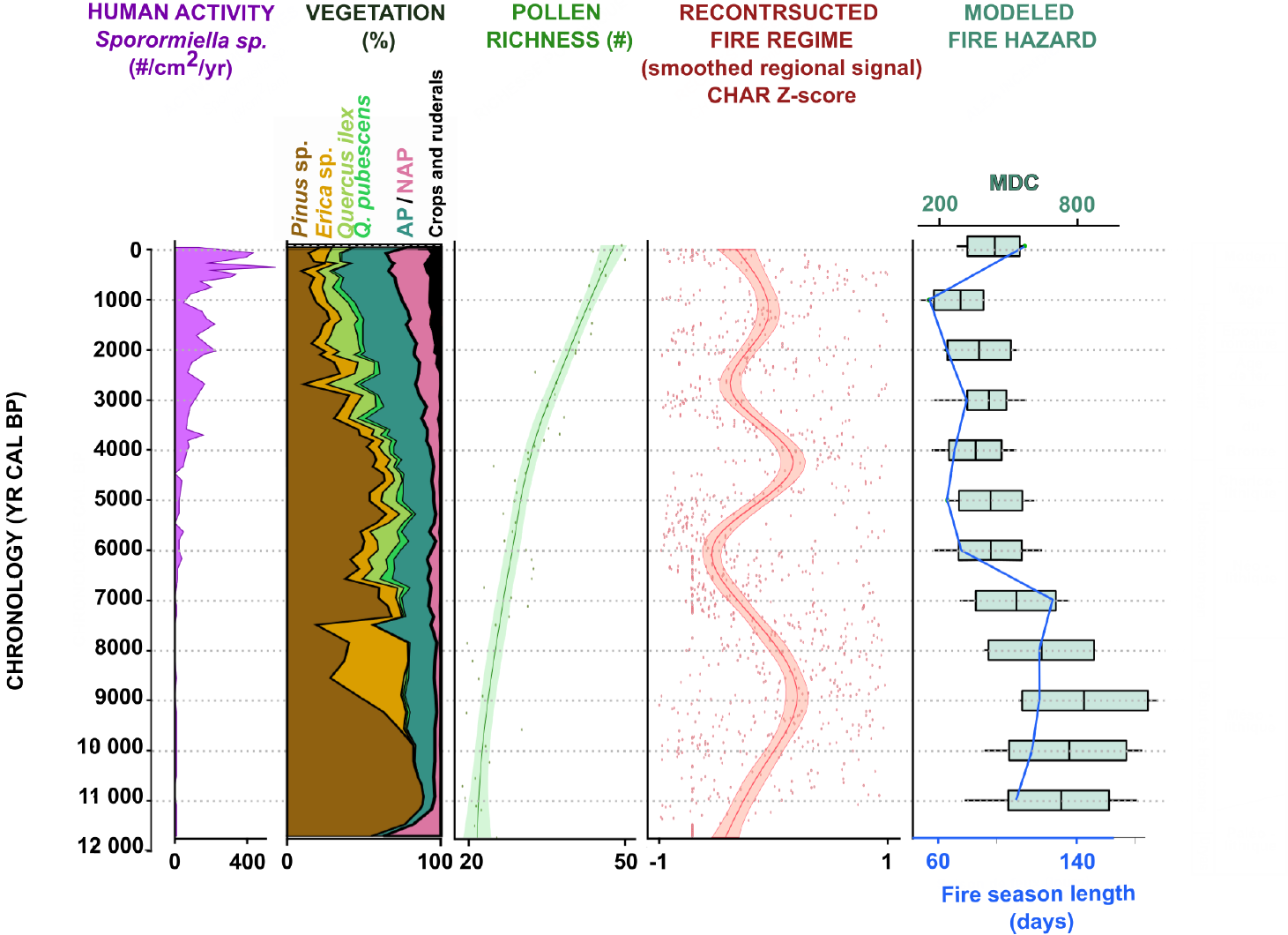
Fires have been frequent in Corsica for at least the last 11,500 years, with two main increases evidenced in paleoecological records (Fig. 1; Lestienne et al. 2020b).
The first increase between 11,500 and 7000 yr cal BP corresponded to the development of Pinus sp. forests during the Early Holocene, followed by shrubby ecosystems dominated by Erica sp. This ecosystem development increased the amount of fuel available near the ground and the connectivity between the ground and the tree tops, promoting crown fires (e.g. Curt et al. 2013). Independent proxy-based studies at the regional scale indicate that this period experienced hot and dry summer climates (e.g. Vannière et al. 2011), i.e. optimal conditions for wildfires to ignite and spread.
 |
|
Figure 1: Synthesis diagram showing the history of human activity, vegetation diversity and fires (charcoal, Monthly Drought Code (MDC), and Fire Season Length (FSL)) in Corsica during the Holocene. The high levels in Sporormiella influx reflect human activity, particularly pasture. The pollen richness is used to evaluate vegetation diversity. A smoothed curve was generated from the resampled and rescaled (Z-score) CHAR values of the three lakes (Bastani, Nino, and Creno) using the LOESS (Locally Estimated Scatterplot Smoothing) method to reconstruct the fire signal. The MDC represents the fire-hazard intensity, while the FSL represents the fire-hazard duration. The two most active fire periods are highlighted in red; the second period is marked by more local signals (see Lestienne et al. 2020b). |
To model fire climate conditions, we used climate-model simulations and adapted two indices derived from the Fire Weather Index estimating the fire hazard (Van Wagner 1987): the Monthly Drought Code (MDC, calculated from air temperature and precipitation; Girardin et al. 2013) and the Fire Season Length (FSL in days; Hély et al. 2010), representing the number of days with MDC > 300 (Lestienne et al. 2020a). Before 7000 yr cal BP, high MDC and FSL values indicate summer droughts conducive to fire. Thus, a combination of climate conditions favorable to fire and fuel availability may explain the frequent fires during the Early Holocene.
The second fire period extended from 5000 yr cal BP to the present. It followed a two-millennia-long period without fire, during which evergreen (Q. ilex-type) and deciduous (Q. pubescens) oak forests expanded, due to superior competitiveness (Colombaroli et al. 2009). After 5000 yr cal BP, landscapes became more open, and fire frequency and pollen-inferred biodiversity increased with the development of crops and pastures (Fig. 1). During this period, the fire signal varied locally (Lestienne et al. 2020b), and lower modeled MDC and FSL values (wetter conditions) support the hypothesis of an anthropogenic cause for the observed fire regime.
Future predictions
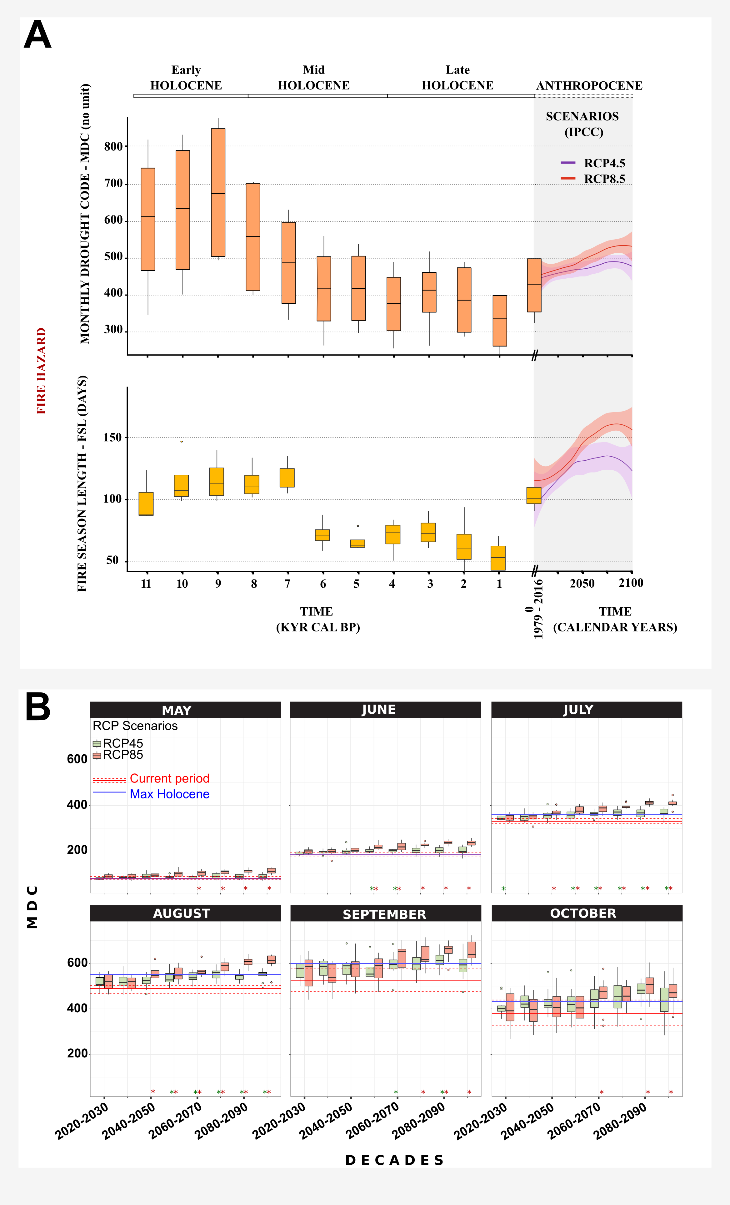
When comparing the Holocene fire hazard indices (MDC and FSL) with the predicted indices for the next eight decades and for two RCP scenarios (4.5 and 8.5), both scenarios show an increase until 2100, with a stronger increase in fire from 2050 using the RCP8.5 scenario (Fig. 2a; Lestienne et al. 2022). The MDC may increase from 424 to 456 (7% increase) for the RCP4.5 scenario and from 429 to 519 (17% increase) for RCP8.5 between 2020 and 2100. Accordingly, a lengthening of the fire season may also be expected (by 25–45 days, i.e. between 19% and 28%). This range of future lengthening of the fire season is in line with the 30 days estimated using previous climate simulations and fire indices (e.g. Giannakopoulos et al. 2005), but so far no study has proposed a Holocene framework for estimating and quantifying the significance of these future changes. Lestienne et al. (2022) showed that during the Holocene, such values (MDC > 400 and FSL > 100 days) have not been reached since 6000 yr cal BP, and the future FSL may exceed the Holocene maximum as early as 2040, regardless of the RCP scenario (Fig. 2b).
 |
|
Figure 2: (A) Fire hazard changes in terms of Monthly Drought Code (MDC) and Fire Season Length (FSL) in Corsica during the Holocene and future decades. (B) MDC monthly means, by month, for the next decades. The blue line represents the maximum Holocene values, and the red lines represent the current means. Figure adapted from Lestienne et al. (2022). |
Our results also show that this global increase will most likely not be the same for each month of the fire season (Fig. 2b; Lestienne et al. 2022): the MDC will reach its maximum during the summer months (June to August) with values higher than those observed during the Holocene maximum in both scenarios, and higher than historical means in the RCP8.5 scenario. The causes for this marked summer drying were investigated by Rowell and Jones (2006), who considered four possible mechanisms: (1) low soil-moisture conditions; (2) large land-sea contrast in warming conditions; (3) positive feedback from summer soil-moisture and precipitation; and (4) remote influences from teleconnections. These changes appear to be similar in both RCP scenarios until 2050 and will, therefore, depend on political and economic choices after 2050 (e.g. the use of green or fossil energy).
Our data suggest that the predicted increase in fire by 2050 will be significantly different from what Corsican ecosystems experienced during the Early Holocene, because other factors (including vegetation and human activities) also impact fire. Most studies agree that increasing drought will strongly contribute to increases in the frequency and intensity of forest fires in the Mediterranean, especially in southern France and Corsica (e.g. Mouillot et al. 2002). Our study complements these results by highlighting the increase in the duration of the fire season and intensification of the fire hazard.
A strong increase in fire occurrence, coupled with drier conditions, could lead to a significant decrease in plant biodiversity in Corsica (e.g. Lestienne et al. 2020b). Such ecological change would lead to significant economic losses (e.g. reduction in tourism). In France, the large fires in the 1990s led to the implementation of a very effective firefighting policy under weather conditions of the last decades (Curt and Frejaville 2018). However, this will likely be challenged by more extreme conditions in the coming years. Over the next 30 years, our current policies will also influence the climate response on longer timescales. Integrative studies combining modeling, long-term data records, and traditional fire knowledge can provide valuable insights to understand fire responses to complex vegetation–human–climate interactions, and support policy decisions in biodiversity hotspot regions such as Corsica.
affiliations
1Chrono-environnement, CNRS, Université Bourgogne Franche-Comté, Besançon, France
2ISEM, Université Montpellier, CNRS, EPHE, IRD, Montpellier, France
3Department of Forest Ecology, Faculty of Forestry and Wood Sciences, Czech University of Life Sciences Prague, Czech Republic
4EPHE, PSL University, Paris, France
5INRAE – RECOVER, Aix Marseille Univ, Aix-en-Provence, France
6MSHE Ledoux, CNRS, Université Bourgogne Franche-Comté, Besançon, France
contact
Marion Lestienne: lestiennefld.czu.cz
references
Colombaroli D et al. (2009) J Biogeogr 36: 314-326
Curt T, Frejaville T (2018) Risk Anal 38: 472-488
Curt T et al. (2013) J Environ Manag 117: 150-161
Curt T et al. (2016) Int J Wildland Fire 25: 785-796
Girardin MP et al. (2013) For Ecol Manage 294: 238-249
Hély C et al. (2010) Geophys Res Lett 37: L14709
Lestienne M et al. (2020a) Fire 3: 8
Lestienne M et al. (2020b) Holocene 30: 244-257
Lestienne M et al. (2022) Clim Change 170: 14
Mouillot F et al. (2002) Glob Chang Biol 8: 423-437
Rowell DP, Jones RG (2006) Clim Dyn 27: 281-299
Charuta Kulkarni![]() 1 and Dhanya Bhaskar
1 and Dhanya Bhaskar![]() 2
2
Building science–policy interfaces is essential for envisioning pragmatic environmental solutions. Drawing from the Western Ghats of India, we identify mutual areas of interest, or "commons", where specific environmental management issues can benefit from a long-term perspective, encouraging paleoscience–policy connections.
Achieving food security while maintaining biodiversity is a key challenge for tropical regions. Sustainable management of these regions is further threatened by global environmental changes that have serious impacts on livelihoods of billions (Gadgil and Guha 1993). Given the long histories of human occupation and the influence of past climates and land-use practices in shaping tropical landscapes, it is essential to incorporate both ecological and cultural legacies in their planning and management (Swanson et al. 2021). Conservation and restoration plans often fail to acknowledge the significance of such legacies (Gillson and Marchant 2014), resulting in conflicts between restoration targets and people's needs (Colombaroli et al. 2021). For example, management policies that are regulatory and/or restrictive (e.g. fire prevention, monoculture afforestation schemes) often contrast with traditional practices that support local livelihoods and undermine the crucial role of past ecological processes (Gadgil and Guha 1993).
With the term "commons", we refer to specific policy conservation/management issues that can benefit from a long-term perspective. Bringing examples from tropical paleoecology and environmental policy, we show how the identification of such mutual areas of interest is pertinent in establishing and expanding paleoscience–policy interfaces. We argue that identification of paleoscience-policy commons is a requisite for effective tropical landscape management where policy-relevant paleo-studies, as well as dialogs between scientific and policy circles, are rare, if not absent.
Tropical agroforestry systems: opportunities for integrating paleosciences into policy
 |
|
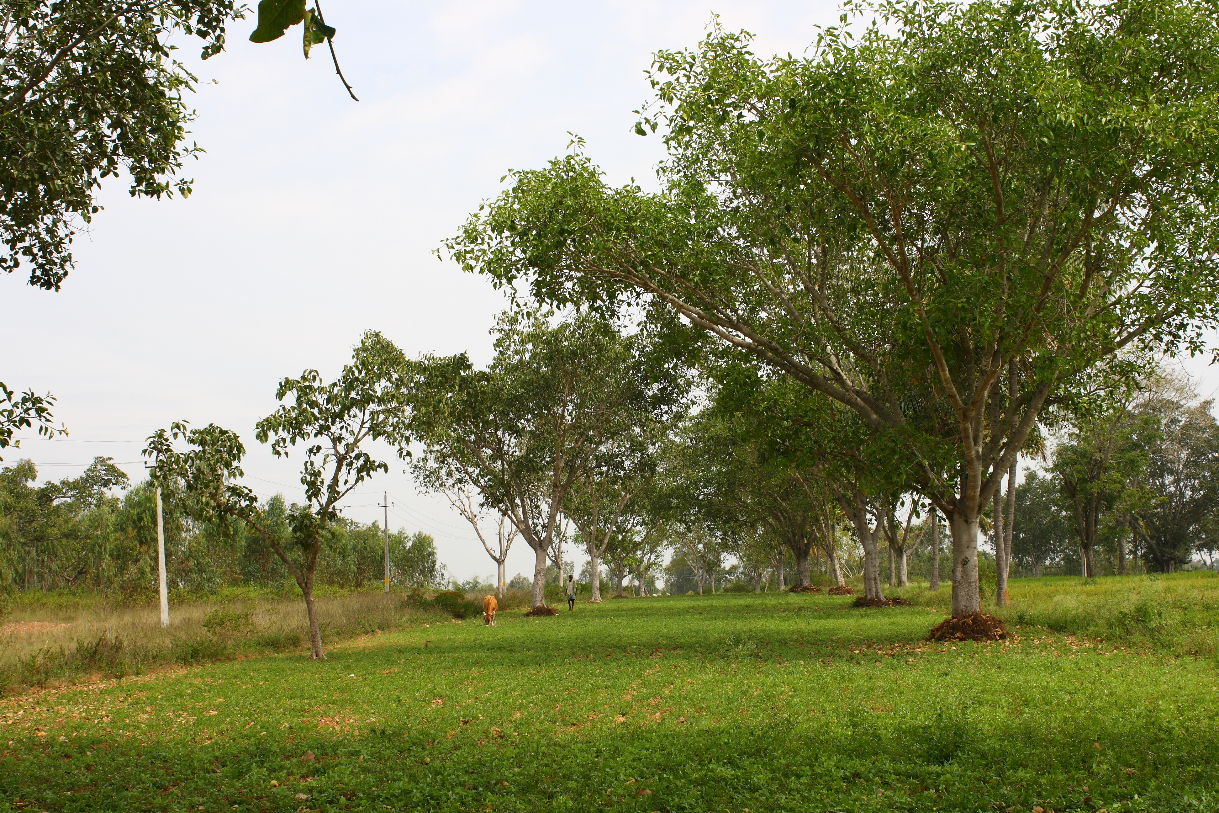
Figure 1: A typical tropical agroforestry landscape integrating native trees and crops (photo credit: Dhanya Bhaskar). |
Agroforestry, the practice of planting crops under or alongside trees, is one of the most widely used land management techniques worldwide (Fig. 1). While supporting the local livelihoods through encouraging intentional management of trees for productive agriculture, agroforestry is also recognized as a promising nature-based solution for the improvement of ecosystem functions, biodiversity conservation, and climate change adaptation (The 4th World Congress on Agroforestry, 2019). Tropical agroforestry landscapes are typical social–ecological systems that have existed for centuries or even millennia – especially those located in the biodiversity hotspots exemplify traditional practices and lessons for the future (e.g. Maezumi et al. 2018; Kulkarni et al. 2021). The Western Ghats, a 1600-km mountain range running parallel to the west coast of India, is one such biodiversity hotspot where tropical rainforests support the highest human population density. In the Western Ghats, high-resolution paleoecological data shed light on the transformation of local agroforestry systems since 4000 cal BP (Fig. 2), revealing their diverse ecological and social dimensions including ancient farming practices, their relationship with monsoonal variability, and fire as a land management strategy (e.g. Bhagwat et al. 2012; Nogué et al. 2018; Kulkarni et al. 2021). The perspectives drawn from these long-term interactions between tropical ecosystems and people offer vital clues for understanding the long-lasting benefits of agroforestry practices and their sustainable management, both of which are envisioned under India's National Agroforestry Policy for synergizing biodiversity conservation and livelihood benefits (Government of India 2014). Below, we present two commons where studies of past ecologies in the Western Ghats with a focus on local policy issues could aid in visualizing appropriate and inclusive management choices:
(1) Conservation and restoration in human-dominated tropical landscapes
India's National Agroforestry Policy focuses on ecosystem protection and resilient farming as important strategies to minimize climate risks (Government of India 2014). Land degradation in the past affected more than 30% of the country's geographical area, thus, in response, the Indian government has committed to restoring 26 Mha of degraded land by 2030 under the United Nations Convention on Combating Desertification (Press Information Bureau 2019). In this context, paleoecological studies show where conservation efforts should be focused and how these can be cognizant of local practices.
 |
|
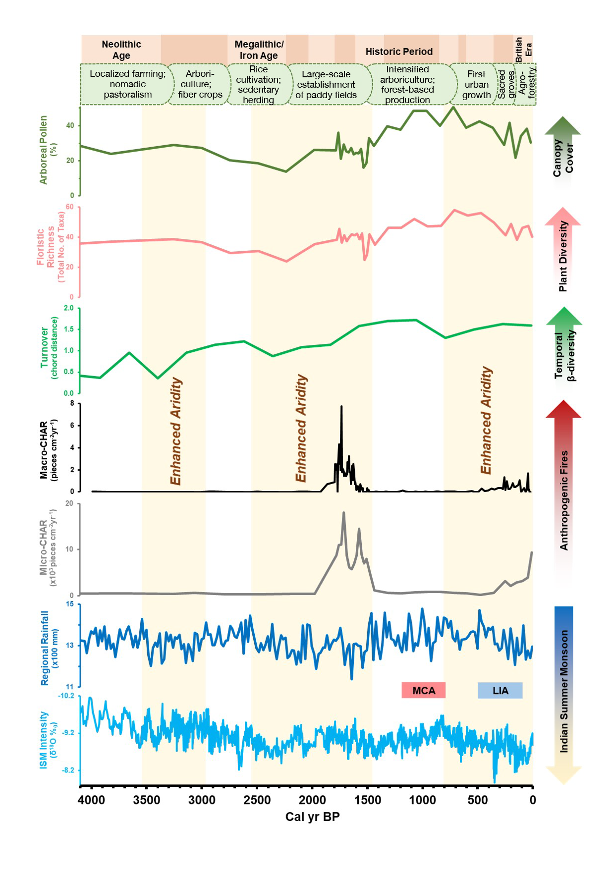
Figure 2: Transformation of the Western Ghats agroforestry landscape over the past 4000 years, showing changes in canopy cover, plant diversity, and fire in relation to the Indian Summer Monsoon variability (Modified from Kulkarni et al. 2021). Paleodata exhibit a high positive correlation between the canopy cover and plant diversity in the Western Ghats and sustained burning episodes during the periods of enhanced aridity, i.e. significant decline in the monsoon. |
For example, pollen-based reconstructions of biodiversity in the Western Ghats highlight a high positive correlation between the canopy cover and plant diversity (Fig. 2), emphasizing the importance of maintaining tree canopies for nurturing highly diverse landscapes (Kulkarni et al. 2021). Paleodata in the Western Ghats also reveal the resilience of native evergreen trees towards varying degrees of land-use change over several millennia. A few native species such as Dipterocarpus, Hopea, and Palaquium are already part of historic baselines and are incorporated in the current planning and restoration of the Western Ghats (Muthuramkumar et al. 2006). To this end, paleoscience imparts empirical support to the existing conservation strategies and recommends that maintaining patches of native trees on agroforestry landscapes should be a key priority for conservation and restoration efforts. This recommendation also speaks to the need for conservation beyond protected areas in human-dominated tropical landscapes, and the short-sighted rationale behind promoting exotic, fast-growing agroforestry species (e.g. Eucalyptus, Casuarina), often under government supported forestry programmes (Garcia et al. 2010).
(2) Fire in agroforested landscapes
Blanket bans on Indigenous fire practices since the colonial times has had serious repercussions on forest succession and forest-dependent livelihoods in many tropical regions (Gadgil and Guha 1993). Studies on fire management from different geographies, including those on traditional fire practices of Soligas in the Western Ghats (Sundaram et al. 2012) and of Pemón communities in Venezuela (Bilbao et al. 2010) unveil how outright banning of Indigenous fire practices leads to high-intensity catastrophic fires and the increased susceptibility of tropical forests towards fires.
In the Western Ghats, Kulkarni et al. (2021) show that sustained burning during dry periods (ca. 2000–1600 and 400–0 yr BP) resulted in increased canopy openings, subsequently reducing plant diversity (Fig. 2). Combined with local knowledge, they highlight how the re-introduction, or maintenance, of traditional low-intensity burns can help prevent fire-spread from peripheral agricultural lands into forest reserves, which are often in close vicinity in human-dominated tropical landscapes. This also implies that the slash-and-burn practices of tropical regions that are often portrayed as destructive, are in fact important in maintaining landscape mosaics and heterogeneity, preventing high-intensity fires and enhancing social-ecological resilience (Thekaekara et al. 2017).
Outlook
Expanding the list of paleoscience–policy commons and complementing them with historical and indigenous knowledge, can better uncover the complex drivers of tropical ecosystem transformations and the processes that maintain both natural and cultural values in landscapes. Such paleoscience–policy connections have the potential to incorporate long-term perspectives in environmental planning and can promote inclusive approaches within policymaking. This can also foster cross-sectoral and interdisciplinary collaborations at the science–policy interfaces (Swanson et al. 2021), enabling us to tackle future conservation challenges and secure livelihoods in the tropics.
affiliations
1Independent researcher; London, UK
2Indian Institute of Forest Management, Bhopal, India
contact
Charuta Kulkarni: ckulkarnigradcenter.cuny.edu
references
Bhagwat SA et al. (2012) Biol Conserv 153: 108-117
Bilbao BA et al. (2010) Hum Ecol 38: 663-673
Colombaroli D et al. (2021) PAGES Mag 29: 54-54
Garcia CA et al. (2010) Conserv Biol 24: 479-488
Gillson L, Marchant RA (2014) Trends Ecol Evol 29: 317-325
Kulkarni C et al. (2021) J Environ Manage 283: 111957
Maezumi SY et al. (2018) Nat Plants 4: 540-547
Muthuramkumar S et al. (2006) Biotropica 38: 143-160
Nogué S et al. (2018) Ecosystems 21: 45-55
Sundaram B et al. (2012) Hum Ecol 40: 931-942
Swanson HA et al. (2021) One Earth 4: 226-237
Thekaekara T et al. (2017) Econ Polit Wkly 52: 22-25
Donna Hawthorne1, D. Colombaroli2 and F.J.G. Mitchell3
Combined paleoecological and archaeological records allow for a detailed examination of past fire–human–vegetation interactions. Focusing on a national park at risk from increasing fire threats, we explore the potential of integrated approaches to inform future fire management and conservation policy.
Fire is increasing in many natural and cultural landscapes due to ongoing climate and land-use changes (Bowman et al. 2020), with potentially long-lasting consequences on ecosystem structure and composition (Kelly et al. 2020). In Ireland, the occurrence of recent wildfires in national parks represents a key challenge for park managers. For example, on one of the hottest days in Ireland in 2021, a fire blazed through ∼1400 hectares of land in Killarney National Park (KNP), severely degrading existing habitats and wildlife. The fire burned for four days and was the largest fire that had occurred within at least the last two decades.
Fires have been increasing in frequency and severity in the region in recent years; however, the scale and impact of the 2021 fire was much larger than expected. In order to mitigate the effects of such catastrophic events, there is a growing need for park managers to understand how ecosystems responded to past fire variability. In Ireland, such a long-term perspective can be provided by multi-site comparisons of archaeological and paleoecological records, offering new insights into the anthropogenic and climatic drivers of past fire regimes (Whitlock et al. 2017). Such long-term perspectives can be used to inform the development of fire management strategies appropriate for varying land-use, climate, or vegetation scenarios (e.g. Willis and Birks 2006; Colombaroli et al. 2017; Brown et al. 2018; Gillson et al. 2019).
Integrated, long-term perspectives are particularly needed in regions where forest management practices such as fire suppression and fire exclusion over the past century have led to largely fire-free landscapes. The primary goal of fire suppression/exclusion is often to protect natural heritage, e.g. semi-natural native woodlands, and is a common practice in Irish national parks. This has likely been the case for KNP since the park's creation in 1932 (and formally since at least 2005, with the creation of a fire-fighting action plan for early wildfire detection and control). Woodlands and grasslands in the park are particularly at risk from severe wildfires, causing woodland margins to recede. Here, we discuss how the combination of archaeological and paleoecological evidence can provide key information about the long-term effects of fires on landscapes, and how such integrated knowledge can better inform ecosystem management in the park.
 |
|
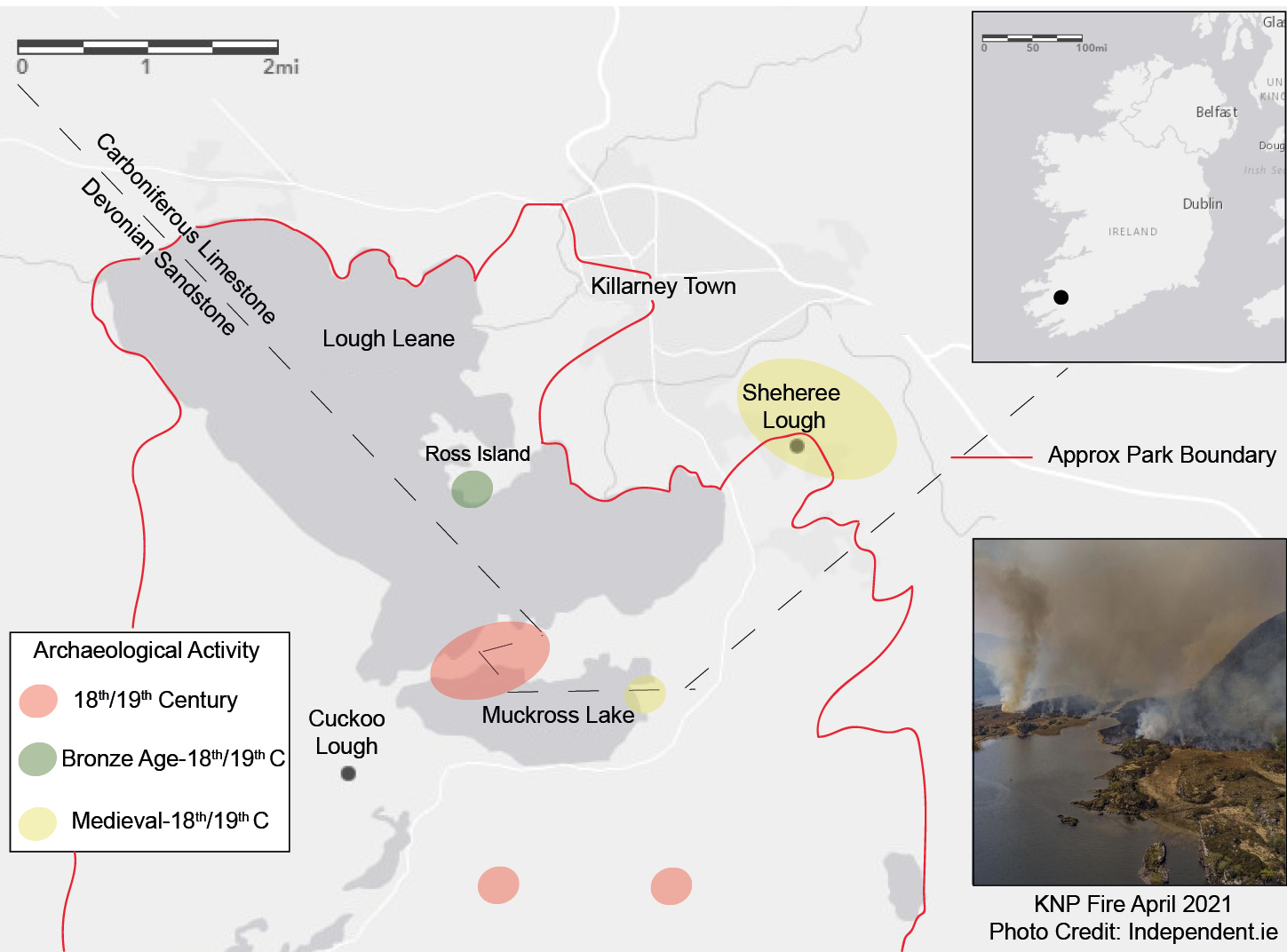
Figure 1: Map of Killarney National Park (KNP), including the location of study sites, underlying geology and archaeological activity. Inset top: location of KNP within Ireland. Inset below: fire in KNP, April 2021. |
Long-term fire–vegetation–climate interactions
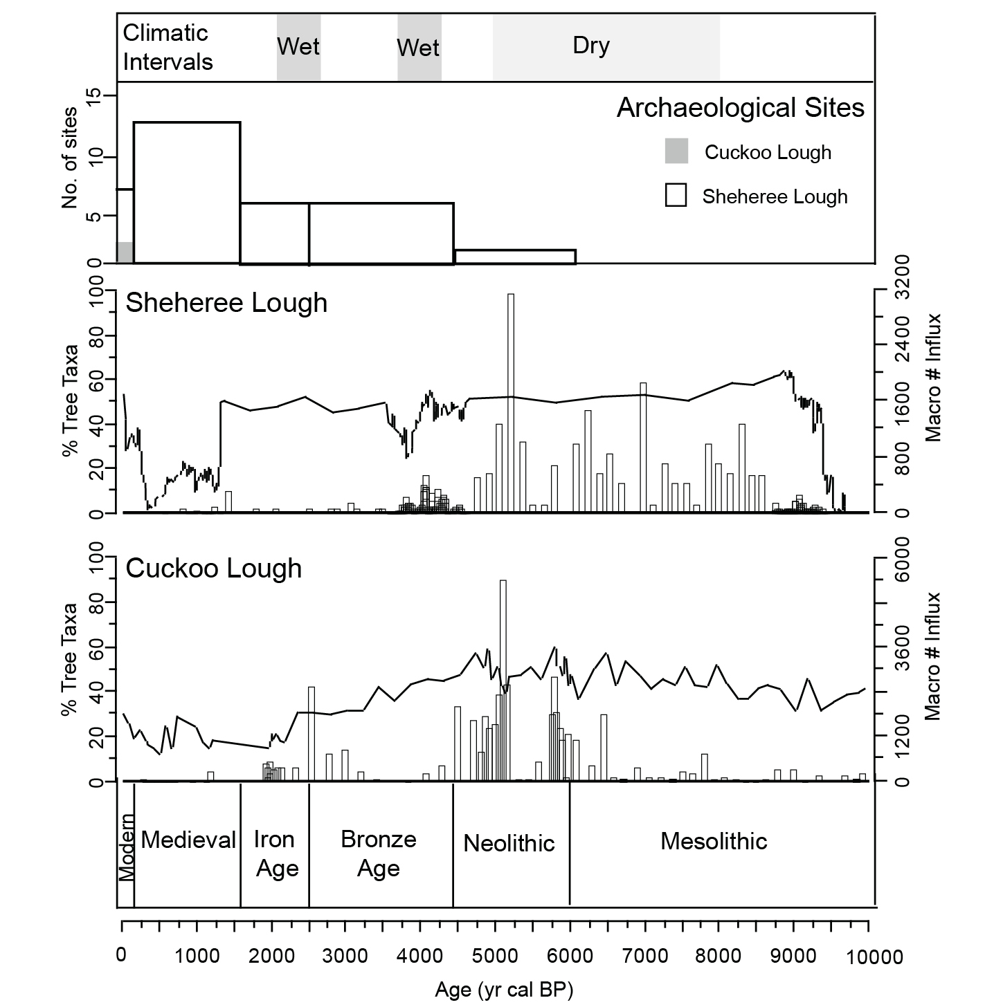
Pollen and charcoal records from two study sites within KNP (Cuckoo Lough: uplands, and Sheheree Lough: lowlands; Fig. 1) provide insights into past fire regimes at the transition from a semi-natural forest to the establishment of modern anthropogenic landscapes. The two sites overlie different bedrocks and elevation, thus highlighting differences in fire trajectories and vegetation development at a more local scale. Paleoecological data show that fire has been part of the Killarney landscape since at least the Late Glacial (ca. 20,000 yr cal BP), which predates all evidence for human occupation (Hawthorne and Mitchell 2018). Peaks in fire activity at ca. 8000–5000 yr cal BP in the lowlands and ca. 7000–4000 yr cal BP in the uplands, coincided with climate amelioration and increased seasonality during the early Holocene (Ghilardi and O'Connell 2013; Mitchell and Cooney 2004). A later peak in fire activity occurred in the uplands ca. 2500 yr cal BP (Fig. 2).
According to the archaeological and paleoclimatic evidence, these maximum fire conditions were largely driven by climate conditions conducive for fire, and enhanced by moderate anthropogenic activities. Climate at the time made the environment more receptive to both natural and anthropogenic fires. These fire periods are associated with an overall decline in fire-sensitive tree taxa (e.g. Ulmus), increases in fire-enhanced species (e.g. Alnus) and the expansion of open, more flammable shrubs and grasses (e.g. Corylus and Poaceae). Importantly, microsite conditions (altitude and bedrock) influenced how the different vegetation responded in the long-term, by promoting individual taxa locally (e.g. increases in Corylus, Alnus, Betula, and Quercus during the Late Neolithic-Bronze Age (5000–2500 yr cal BP).
The increasing role of humans driving fire and vegetation changes in the KNP
Over the last few millennia, fire controls shifted from climatic to predominantly anthropogenic. Fire disturbances increased, particularly since the Bronze Age, when a combination of human activities in different areas of the park had a long-lasting and pervasive effect on vegetation structure and composition (Hawthorne et al. 2021).
Combined paleoecological and archaeological data show significant differences in the timing and intensity of human activity at both sites. Conditions in the uplands were less suitable for agriculture due to their lower fertility, and human activity was rather low until the 18th–19th centuries (Cuckoo Lough; Fig. 2). In contrast, in the lowlands (Sheheree Lough; Fig. 2), periods of increased fire activity (∼3800 yr cal BP and ∼1300 yr cal BP) roughly correspond to mining activity (e.g. between 3900–3400 and 1300–1000 yr cal BP; see O'Brien 2004), despite the wet and cool climatic conditions at that time (∼4250 and 3750 yr cal BP; Swindles et al. 2013). From ∼3500 yr cal BP evidence for the expansion of agriculture, suggests that these practices supported the Bronze Age mining activities on nearby Ross Island, which peaked ∼3300 yr cal BP and continued until the 18th–19th centuries (O'Brien 2004). Forest decline continued in the last ∼1000 years, synchronous with archaeological sites dated to the Early Medieval period. Taken together, the matching paleoecological and archaeological evidence shows the transition from ecosystems largely shaped by anthropogenic fires to the final establishment of more open landscapes, presently under more fuel-limited conditions.
 |
|
Figure 2: Summary of paleoecological and archaeological evidence from Cuckoo and Sheheree Lough, by archaeological period. Macroscopic charcoal influx (particles/cm2/yr; bars) is presented with total tree taxa (%; line). Number of archaeological sites are also presented with wet and dry climatic periods denoted from the literature. |
Implications for fire management and ecosystem conservation in the park
Current fire management plans within KNP are limited to fire detection and control/suppression, with the priority of preserving the park's archaeological and natural heritage. Such management strategies are presently challenged by the occurrence of severe fire events during exceptionally dry years. The frequency and severity of fires in Ireland has been increasing in the past decade, and there is a clear and growing need for management strategies to meet these new challenges.
Paleoecological and archaeological data can assist in identifying best approaches that can guide future conservation and landscape management strategies (e.g. Gillson 2019; Whitlock et al. 2017). In the case of KNP, records show that fires were part of the park's long-term history, similar to other temperate regions (Whitlock et al. 2015, 2017). In the past, maximum fire conditions occurred when climate conditions were conducive for fires, and fire activity was intensified by moderate human impact (e.g. between the Late Neolithic-Bronze Age; Fig. 2). In the long term, such fire activity was important for maintaining species that are more fire-adapted locally (e.g. Corylus, Alnus, Betula). The establishment of open habitats only occurred when agricultural practices intensified, leading to marked reductions in forest biomass.
Overall, the KNP case study shows how both climatic and anthropogenic factors created a complex mosaic of vegetation communities, which supported varying fire regimes over time. These historical legacies on present landscapes are key for understanding the conservation of landscapes under current and future climates (Whitlock et al. 2017). Today, the hyper-oceanic climate of the region renders the lowland native broadleaved woodland less fire-prone; however, this may change rapidly under future warmer temperatures (de Rigo et al. 2017). In contrast, in upland areas the open land between woodland patches is dominated by the heather Calluna vulgaris and the grass Molinia caerulea, fire-prone vegetation types, which in turn could impact the edges of the woodlands. Open Calluna vulgaris and Molinia caerulea communities are maintained by grazing from deer populations; hence, a reduction in deer numbers would permit woodland expansion and, thus, reduced scope for fires under present climatic conditions. Instead, the pasture land in the lowlands is managed more intensively and tends not to support fire. A more robust, evidence-based plan for the conservation and management of the park can be achieved by conservation policies that better reflect conditions at the landscape scale, through the integration of all the available evidence, including modern, paleoecological, and archaeological.
affiliations
1School of Geography and Sustainable Development, University of St. Andrews, UK
2Department of Geography, Royal Holloway University of London, UK
3Botany Department, School of Natural Science, Trinity College Dublin, Ireland
contact
Donna Hawthorne: dj43st-andrews.ac.uk
references
Bowman DM et al. (2020) Nat Rev Earth Environ 1: 500-515
Colombaroli D et al. (2017) PAGES Mag 25: 78-79
Ghilardi B, O'Connell M (2013) Veg Hist Archaeobot 22: 99-114
Gillson L et al. (2019) Ecol Soc 24: 14
Hawthorne D, Mitchell FJG (2018) Quat Int 488: 58-66
Hawthorne D et al. (2021) Proc Geol Assoc, doi:10.1016/j.pgeola.2021.09.004
Kelly LT et al. (2020) Science 370: eabb0355
Mitchell FJG, Cooney T (2004) In: O'Brien W (Ed) Ross Island: Mining, Metal and Society in Early Ireland, Bronze Age Studies: 6. National University of Ireland, 481-493
O'Brien W (Ed) (2004) Ross Island: Mining, Metal and Society in Early Ireland, Bronze Age Studies: 6. National University of Ireland, 768 pp
Swindles GT et al. (2013) Earth Sci Rev 126: 300-320
Whitlock C et al. (2015) BioScience 65: 151-163
Estelle Razanatsoa![]() and Lindsey Gillson
and Lindsey Gillson![]()
In the face of a changing environment linked to increased drought and depletion of natural resources, paleoecological data of the last 2000 years show how communities in southwestern Madagascar adopted both incremental and transformational adaptations that allowed them to cope with environmental variability.
SW Madagascar: a case study illustrating a global challenge
Dealing with the consequences of climate change on Earth requires conserving the world's biodiversity, while managing ecosystem services sustainably. Sustainability requires meeting the needs of current and future generations, and keeping open their options to adapt (United Nations 2015). Understanding landscape history can help to determine what is sustainable in a changing environment, while understanding adaptations of past societies may provide stakeholders with a more solid basis for dealing with future changes (e.g. Razanatsoa et al. 2021).
This approach is particularly important in climate hotspots as these areas will experience higher magnitudes and rates of change in the near future (United Nations 2015). Vulnerability to future climate change is exacerbated in areas such as southwest Madagascar, where natural resources are already being depleted (Razanatsoa et al. 2021). Southwest Madagascar is known for its arid climate, receiving less than 500 mm per year of rainfall on average. The region is currently experiencing recurrent droughts that are predicted to become more extreme in the future (Waeber et al. 2015; Masson-Delmotte 2021).
Climate reconstructions show variable climate conditions in Madagascar, with evidence of drier phases over the last 2000 years (Vallet-Coulomb et al. 2006; Virah-Sawmy et al. 2016). Multiple lines of evidence have pointed out changes in ecosystems in the region responding to this climate variability (e.g. Godfrey et al. 2021; Razanatsoa et al. 2022; Virah-Sawmy et al. 2016) but also to land-use change as a response to environmental change. Increase in grass abundance was recorded around 1 kyr BP and the near present time, both linked to changes in land use particularly with the use of fire (Razanatsoa et al. 2021). In these landscapes, humans have adapted to changing climate both "incrementally", i.e. through an extension of activities to their existing livelihood, or adopting a more "transformational" approach, i.e. with shift from one form of activities to another (Kates et al. 2012).
 |
|
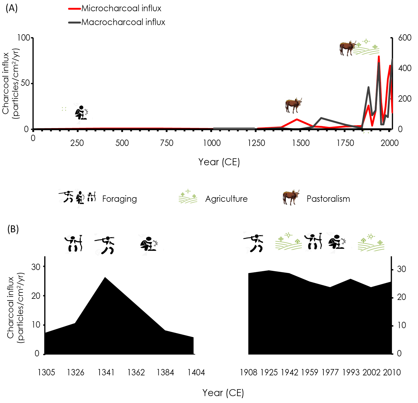
Figure 1: Fire variability inferred from charcoal records and associated livelihood practices. (A) Lake Longiza covering the last 2000 years (adapted from Razanatsoa et al. 2022); (B) Lake Tsizavatsy covering the 14th and 20th centuries (Razanatsoa et al. 2021). |
Contrasting livelihood strategies
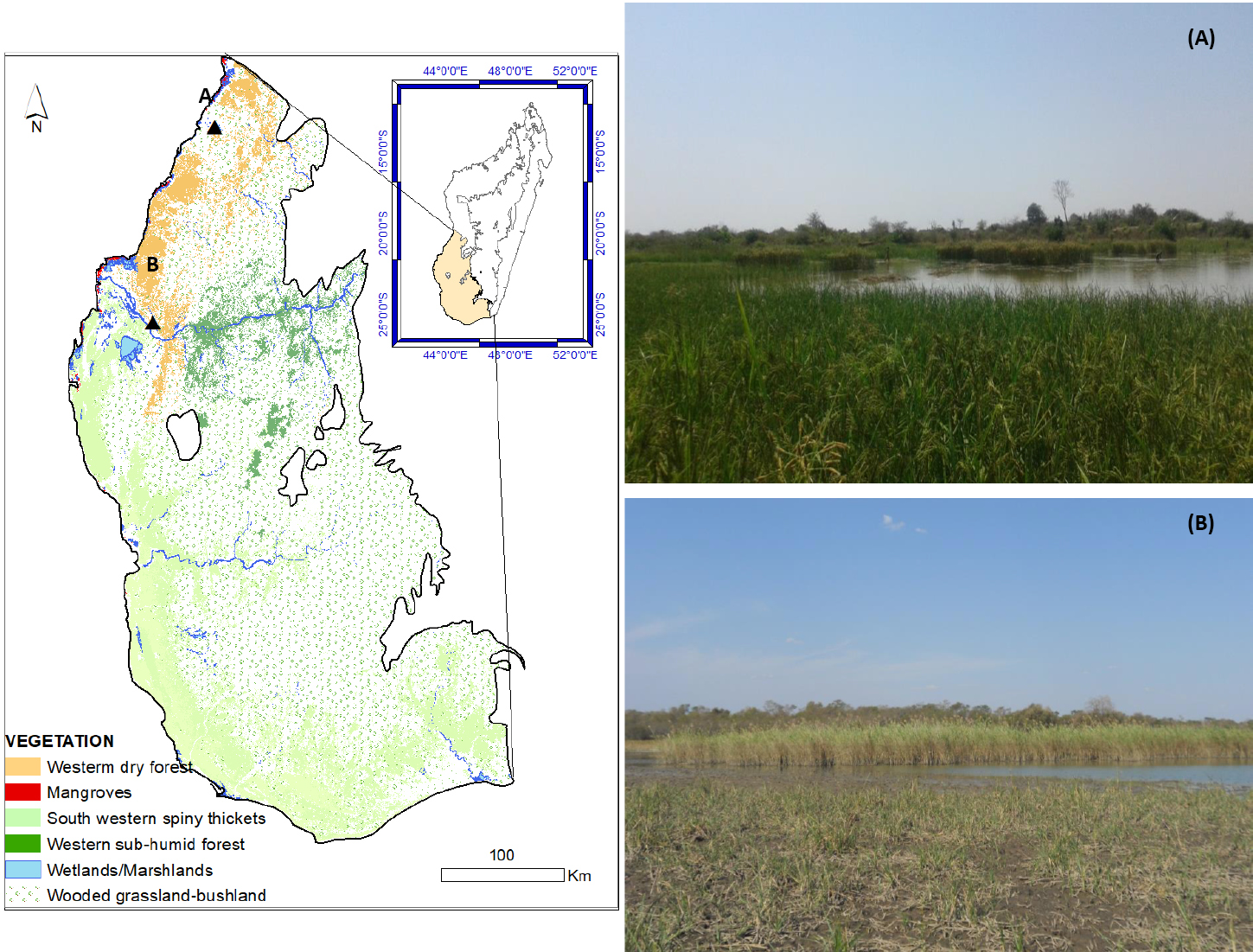
Southwest Madagascar is presently occupied by agropastoralists and forager communities. Agropastoralism dominates around Longiza, while foraging is still prevalent near Tsizavatsy (Fig. 1). Over the last 2000 years, these communities have adapted their livelihood in response to environmental change and economic growth (Razanatsoa et al. 2022).
The communities living around Lake Longiza currently practice agropastoralism as their main livelihood, but have shifted their subsistence strategies and livelihoods over time. Early occupants of the southwest region were probably foragers (Anderson et al. 2018). Increasing charcoal influx and coprophilous spore concentration (Fig. 2) suggest that fire has been used to support agricultural practices and pastoralism activities in the area since 600 CE (Fig. 1; Anderson et al. 2018). The first charcoal peaks at Lake Longiza are recorded around 1300 CE (microscopic charcoal) and 1500 CE (macroscopic charcoal), suggesting that pastoralism started around that time. Domestic cattle were introduced to the island of Madagascar around 700 CE, and expanded to the southwest by 1300 CE. Dung fungal spores reflecting the presence of herbivores likely indicate a shift in human practices from foraging to agropastoralism (Razanatsoa et al. 2022).
In contrast to the transformational shift in livelihoods near Lake Longiza, people near Lake Tsizavatsy have demonstrated a form of incremental adaptation in response to drying, and the associated changes in resources (Razanatsoa et al. 2021). Following a marked increase in fire activity at the beginning of the 20th century (Fig. 2), fire activity remained constant during the following decades, maintained by the current practices of swidden agriculture between December and March (Razanatsoa et al. 2021; Fig. 2). In response to the drying in their region, the Mikea communities living in southwest Madagascar reinforced their traditional practices of foraging (mainly used during the 13th century), and incorporated seasonal agriculture as a new coping strategy in the 20th century (Razanatsoa et al. 2021).
Local adaptations to drying climate
Paleorecords from the region indicate massive environmental changes (e.g. Razanatsoa et al. 2022). Around Lake Longiza, the communities abandoned their initial foraging practices to become agropastoralists (Razanatsoa et al. 2022). Such a transformation was likely possible because the region is currently known to have higher sources of water through river systems, more fertile soils (compared to the south), and is supported by international trade.
Such a shift was probably not possible around Lake Tsizavatsy because of the less fertile soils with unconsolidated sand (Seddon et al. 2000), and the more arid conditions. As a result, a complete abandonment of foraging is less likely at Lake Tsizavatsy, as water availability is too unpredictable to sustain permanent agropastoralism. Thus, agropastoralism provides an additional livelihood when conditions permit, but foraging remains important, especially in years that are too dry to support crop cultivation. Although experiencing a decreasing trend of rainfall and recurrent drought, the adaptation of these two communities depended entirely on local environmental conditions.
The aforementioned factors including the change in land use and climate variability have contributed to changes in the vegetation in southwest Madagascar. Increase in Poaceae (ca. 51% to 65%) suggests an opening of ecosystems around 1900 CE linked to agropastoralism around Lake Longiza (Razanatsoa et al. 2022), likely at the expense of a more diverse and heterogeneous landscape. With changing climate conditions, evidence of increasing dry-adapted plants is recorded around 1000 CE and 1700 CE (Razanatsoa et al. 2022). In particular, these led to a decrease in natural resources for the early forager communities and the need for new subsistence strategies at the expense of the local biodiversity.
 |
|
Figure 2: Fire variability inferred from charcoal records and associated livelihood practices. (A) Lake Longiza covering the last 2000 years (adapted from Razanatsoa et al. 2022); (B) Lake Tsizavatsy covering the 14th and 20th centuries (Razanatsoa et al. 2021). |
Outlook
More challenges for food production, and, thus, food security, are expected for the African continent under a 1.5°C global temperature increase accompanied with increased drought in arid and semi-arid regions (Serdeczny et al. 2017; Masson-Delmotte 2021). Paleoecological data show that the decline and shift in vegetation associated with a reduction in ecosystem services such as fuel wood, sources of food, and medicine for these resource-dependent communities will lead to changes in human livelihood (Razanatsoa et al. 2022). Previous shifts in subsistence strategies have been attributed to factors including (but not limited to) the arrival and expansion of pastoralism and international trade.
While agropastoralism continues to expand with the growing population in Madagascar, the capacity of landscapes to sustain this is finite. In addition, a decrease in rice and maize production is projected in tropical regions under a +2°C scenario, making such practices less sustainable (Challinor et al. 2016). With these projections, current livelihoods will become more challenging, requiring more transformational and incremental adaptation. However, adaptation strategies should consider biotic and abiotic components of ecosystems in order to maintain the ecological infrastructure that will ultimately sustain the survival of its people. These last forager communities are likely to be forced into a larger shift in their livelihoods as they become more vulnerable (Razanatsoa et al. 2021), highlighting the need for more diversified livelihoods. This could be achieved through the participation of local and national stakeholders in formulating coherent adaptation strategies to enhance the resilience of forest-dependent communities to a changing climate (Saalu et al. 2020) but also the establishment of self-organized local institutions within local and Indigenous communities (Berman et al. 2020).
These case studies reflect a broader context on how social and ecological dimensions of biodiversity conservation and climate change adaptation can be in conflict, and should be tackled together. Paleodata provides insight into what happened in the past and how various communities adapted their livelihood to past environmental changes, and provides a basis for exploring future scenarios. It is important to note that the challenges people and ecosystems are facing today are unprecedented. Such challenges can only be tackled through collaboration and integration of various forms of knowledge into scenario planning and policy, if both the quality of life and level of biodiversity are to be maintained in a changing world.
Acknowledgements
We acknowledge support from a faculty PhD fellowship (University of Cape Town), the Applied Centre for Climate and Earth Systems Science (ACCESS NRF UID 98018), the University Research Committee (URC) accredited by the University of Cape Town, the NRF/SASSCAL (Southern African Science Service Centre grant number 118589), the NRF/African Origins Platform (grant number 117666), and the NRF Competitive Programme for Rated Researchers (Grant Number 118538).
affiliation
Plant Conservation Unit, Department of Biological Science, University of Cape Town, South Africa
contact
Estelle Razanatsoa: estelle.razanatsoauct.ac.za
references
Anderson A et al. (2018) PLoS One 13: e0204368
Berman M et al. (2020) Clim Change 159: 1-16
Challinor A et al. (2016) Nat Clim Change 6: 954-958
Godfrey LR et al. (2021) Front Ecol Evol 9: 742203
Kates et al. (2012) Proc Natl Acad Sci USA 109 (19): 7156-7161
Razanatsoa E et al. (2021) Malagasy Nature 15: 41-45
Razanatsoa E et al. (2022). Holocene 32: 57-69
Saalu FN et al. (2020) Int J Clim Chang Strateg Manag 12: 1-21
Serdeczny O et al. (2017) Reg Environ Change 17:1585-1600
Seddon N et al. (2000) Oryx 34: 287-304
Vallet-Coulomb C et al. (2006) J Geochem Explor 88: 153-156
Michael R. Coughlan1, T.L. Gragson2 and D.S. Leigh3
Multi-proxy evidence suggests that pastoral fire use has spanned thousands of years in the western Pyrenees. Our place-based integration of traditional knowledge with paleoecological, historical, and archaeological sciences points to Basque pastoral burning techniques as effective tools for conserving the cultural landscapes of the Pyrenees.
Basque stock raisers (éleveurs in French) in the western Pyrenees use fire as a tool to manage hedgerows and to clean and renew meadows and pastures (Coughlan 2013, 2014). Scholars generally recognize that the practice of "pastoral fire" (feu pastoral in French) is ancient and that it historically played a significant role in land management in the Pyrenees (Métailié 2006). Yet, the practice of pastoral fire is heavily regulated by the French state and continues to be regarded with suspicion by many forest- and fire-management officials who consider it a haphazard and environmentally irresponsible practice (Coughlan 2013). Given these competing narratives, the appropriateness (perhaps necessity) of pastoral fire as a landscape conservation tool is seldom considered.
Our place-based investigation of pastoral fire integrates diverse types of knowledge (i.e. traditional knowledge in addition to historical, archaeological, and paleoecological archives) to understand when the practice first began and the long-term effects of burning on soils and vegetation patterns within an ethnically Basque province of Soule (Xiberoa in Souletin Basque) in the French western Pyrenees. Our results point to traditional pastoral fire use as a practical and effective tool for conserving ancient cultural landscapes comprised of forest-meadow mosaics and seasonal upland pastures.
Ethnography of pastoral fire use
Basque peoples have likely inhabited the western Pyrenees for at least the last several thousand years, culturally adapting to, and shaping, the environment there (Gragson et al. 2020). Generation after generation of Basque shepherds have successfully passed on the place-based traditional knowledge of how to burn landscapes in ways that help to ensure the long-term sustainability of ecosystem goods and services.
 |
|
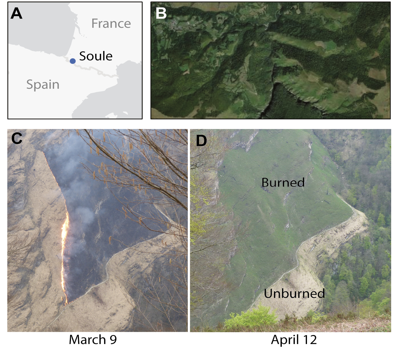
Figure 1: (A) Location of Soule (Xiberoa); (B) Basque cultural landscape mosaic; (C) Photo of pastoral fire lit on 9 March 2011 above a footpath serving as a firebreak; (D) Photo of the same area about a month later on 12 April. The burned grasses have re-sprouted with renewed growth, whereas the unburned area remains covered in last year’s less palatable cured grasses (photo credits: Michael Coughlan). |
Following this long tradition, today's stock raisers set culturally prescribed fires in the mid-elevation mountains (300–800 m asl) with relative ease during mid to late winter months, and higher up the mountainside in the early spring. Bracken (Pterdidium spp.) and false broom (Brachypodium sylvaticum) growing in the mid-elevation forest-meadow matrix are the first to be burned. These fires remove the unpalatable cured grasses from the previous growing season, but also burn seedlings and new sprouts from tree roots, which prevents the encroachment of trees into pastures and meadows. New grass shoots soon appear, resulting in nutrient-rich forage for the transhumant livestock herds as they are shepherded toward higher elevation summer pastures (Fig. 1).
This burning usually takes place in February and March, when the weather patterns have shifted from a cool and wet Atlantic pattern, to a sunny and warm Mediterranean pattern, driven by dry Foehn winds. Fuels are cured and ready to burn after about three days of sunny, warm weather, and fires spread rapidly until petering out at the edge of the forest where they are extinguished by the more humid, less flammable fuels under the beech (Fagus sylvatica) forest canopy. On more sheltered slopes, clumps of heather (Calluna vulgaris) and gorse (Ulex europaeus) are generally ignited individually. These burn rapidly, creating copious amounts of smoke, but due to their patchy growth, they require multiple ignition points. Common juniper (Juniperus communis) is treated similarly at higher elevations. Burning above 800 m asl generally begins in late March and runs into May, although smaller fires, sometimes targeting individual shrubs, are set throughout the summer months.
Paleoecological evidence for woodland-to-pasture conversion
Multiproxy paleoecological evidence (i.e. charcoal, soil magnetic susceptibility, acrolein and polycyclic aromatic hydrocarbons, chemical compounds that are indicative of fire and strongly bound to soil particles) derived from stratigraphically sampled slopewash deposits (zero-order, small hollow colluvium) show a distinct increase in fire activity around 5000–6000 yr before present (BP), based on radiocarbon chronologies (Fig. 2; Leigh et al. 2015, 2016; Gragson et al. 2020; Coughlan et al. in press). These paleoenvironmental archives occur in continuous sedimentation records from about 18,000 yr BP to the present and suggest that late Neolithic people pioneered intentional use of fire in a region where natural fires were rare (Jalut et al. 2000). Non-synchronous peaks in proxies from different sediment sample sites indicate a highly localized, as opposed to regional, pattern of fire use, especially during the Neolithic through to the Bronze Age. Following the Bronze Age, charcoal concentrations steadily increased or remained high, indicating widespread use of fire. Pronounced sedimentation rates spike in conjunction with some of the Iron Age through Middle Age peaks in charcoal, suggesting excessive levels of soil erosion, but sedimentation rates generally settled down by Modern times. Thick, organic-rich horizons of modern soils indicate that the fire-based land management practices contribute to sustainability of soils.
 |
|
Figure 2: Multiproxy evidence for fire from the "Ihitsaga" sample site, a zero-order hollow along the Pyrenean divide. Radiocarbon dating samples are indicated by [s] for soil matrix and [ch] for charcoal with ages in thousands of years before present (kyr BP). |
Historical and archaeological evidence for the persistence of pastoral economies
An archaeological survey of approximately 4710 hectares of upland pastures (elevations greater than 800 m asl) located nearly 200 archaeological features (stone and earthen foundations, enclosures, and mounds) thought to be associated with seasonal herding activities (Le Couédic et al. 2014). Based on 24 radiocarbon dates of charcoal from seven widespread archaeological features, land-use intensity in the upland pastures peaked only in the last 1000 years (Gragson et al. 2020; Coughlan et al. in press). This archaeological evidence for land-use intensification coincides with historical and archaeological evidence for year-round settlement of nearby farming households located between 300 and 600 m asl. Historical records show that farming communities accessing the upland pastures in Soule have existed since at least the 11th century CE (Gragson et al. 2020). Diverse historical documents suggest that many of the household farm estates at the foot of these pastures were established at least 500–600 years ago, but some of these were abandoned in the latter half of the 20th century (Gragson et al. 2015; Coughlan and Gragson 2016).
An archaeological survey of approximately 18 household farm estates and surrounding communal areas suggested that settlement density, in terms of domestic and agricultural structures, reached its maximum around the late 18th to early 19th century (Coughlan and Gragson 2016). This timing coincides with parcel-level land-use mapping recorded in the 1830 Napoleonic cadaster, thus providing a record of the landscape at its most intensive period of use. Records and observations from recent decades show that pastoral fires have been confined to areas that were registered as pasture land-use in the 1830 cadaster (Coughlan 2013). Comparison of historical aerial photos (1940s-2003) and digitally mapped cadastral records from the 1830s suggest that forest–pasture edges have remained relatively stable over the last 200 years. Further, tree-ring archives show that trees along the forest-pasture boundaries predate the 1830 mapping efforts (Gragson et al. 2020). In other words, despite persistent and frequent use of fire, pastures have not expanded beyond their 1830 boundaries.
Implications for landscape conservation
The integration and synthesis of these diverse forms of evidence suggest that pastoral fire is a stable management practice that has helped to maintain a cultural landscape mosaic of pastures and forests (Coughlan 2014). Contemporary Basque stock raisers face a number of social and economic challenges, and many are abandoning agriculture altogether. A small number of remaining stock raisers continue to employ traditional burning techniques, but find it difficult to meet their management goals while complying with protocols spelled out in official regulations. Land managers and policymakers in Europe and elsewhere can learn from traditional pastoral fire and should make efforts to facilitate the continuation of this vital ancient management practice.
affiliations
1Institute for a Sustainable Environment, University of Oregon, Eugene, OR, USA
2Department of Anthropology, University of Georgia, Athens, GA, USA
3Department of Geography, University of Georgia, Athens, GA, USA
contact
Michael R. Coughlan: mcoughlauoregon.edu
references
Coughlan MR (2013) J Ethnobiol 33: 86-104
Coughlan MR (2014) For Ecol Manage 312: 55-66
Coughlan MR, Gragson TL (2016) Hum Ecol 44: 65-80
Coughlan MR et al. (In Press) In: Garcia A (Ed) Archaeology Of Mountain Landscapes: Interdisciplinary Research Strategies Of Agro-Pastoralism In Upland Regions. SUNY Press
Gragson TL et al. (2020) Sustainability 12: 3882
Jalut G et al. (2000) Palaeogeogr Palaeoclimatol Palaeoecol 160: 255-290
Le Couédic M et al. (2014) ITEM, EA 3002. Université de Pau et des Pays de l'Adour, 129 pp
Leigh DS et al. (2015) Zeitschrift für Geomorphol 59: 225-245
Lane B. Johnson1, E.R. Larson2, K.G. Gill1 and J. Savage3
Tree-ring records of frequent fire in northern Minnesota are increasingly recognized as eco-cultural phenomena. Indigenous perspectives provide the cultural context to reinterpret tree-ring fire-scar records in ignition-limited systems like the Upper Great Lakes Region.
People in the fire environment of the Upper Great Lakes Region
Ideal environmental policy represents a synthesis of ecological knowledge, diverse values, and cultures that guides collective action toward balanced outcomes. Achieving this ideal may seem daunting, but lessons for Western scientists provided by paleoecological records are increasingly clear in how best to pursue it: listen. Quantitative environmental history derived from proxies like charcoal, pollen, and tree rings illustrate the what of history; engaging with Indigenous knowledge systems is how researchers might better understand the why of history. Such is the emerging case of fire history research at the University of Minnesota Cloquet Forestry Center, USA, where the tree-ring record of frequent fire (what) is being re-examined as an eco-cultural phenomenon (why).
The vegetation communities of the Upper Great Lakes Region of North America assembled over millennia following the recession of continental ice sheets. Two factors were part of this process since time immemorial: fire and people. For the last 12,000 years people have been an integral component of fire-shaped landscapes, influencing when and where fires burned. Indigenous people modified vegetation conditions over generations, reinforcing and accentuating landscape patterns through the intentional application of fire long before Euro-American colonization reshaped fire dynamics to a largely fire-excluded state. Here, we report on part of a growing network of tree-ring-based fire-history sites in the Upper Great Lakes Region to convey how a cross-cultural perspective better explains the causes of frequent fire in forest ecosystems widely considered to be ignition-limited (Balch et al. 2017).
 |
|
Figure 1: Historical (left) and current (right) forest conditions in the Camp 8 stand (Fig. 2), one of the sites sampled for fire history. Euro-American fire suppression practices that prohibited Indigenous fire stewardship gradually shifted fire-maintained open woodlands and forests to fire-excluded states that would be unrecognizable to the inhabitants of these landscapes a century ago (Source: University of Minnesota Archives; Eli Sagor). |
Indigenous land with University of Minnesota presence since 1909
Nagaajiwanaang, the Reservation of the Fond du Lac (FDL) Band of Lake Superior Chippewa – known as Anishinaabe/g [sing./plural], meaning the "original people", and part of a group of culturally affiliated tribal communities in the Great Lakes region of North America – was established through the 1854 Treaty of La Pointe and opened to Euro-American colonization by the United States government in 1905. Through the contentious process of allotment, "excess" Anishinaabe land was sold to Euro-Americans, advancing the encroachment of white colonizers on lands once held collectively by the FDL Anishinaabe (Akee 2020). The University of Minnesota Cloquet Forestry Center (University forest) is one example of the 86 million acres of Indigenous lands removed from collective ownership between 1905 and 1909 in the United States (Catton 2016). This dramatic shift in land ownership coincided with concerted state and national efforts to suppress wildland fires and terminate Indigenous cultures.
The University forest is a 1375-hectare research forest established within the FDL Reservation in 1909 near the lumber mill city of Cloquet. The University forest is 50 km southwest of Lake Superior (Gichi-Ojibwe-gamiing) and lies on a rolling sand plain that spans a subtle height of land between the Lake Superior and Mississippi River (Mishi-ziibi) watersheds. Fire-shaped pine barrens functioned as an overland travel corridor that connected the historical and contemporary FDL communities of Cloquet (Mookomaani-onigaming) and Sawyer (Gwaaba-iganing). A narrow stream called Otter Creek (Nigigo-ziibiwishe) is the most distinctive perennial water feature in the University forest.
Establishment of the University forest coincided with a campaign to entirely exclude fire from the property following widespread logging. The primary goal of the first forester-in-charge was to create a network of roads and fire breaks to prevent the loss of timber resources to fire. The work was effective. Interestingly, university records indicate no lightning-caused fires on the forest since 1910. Human-caused fires, however, were common, with "blueberry pickers" linked to several ignitions in the early 1900s (Schantz-Hansen 1960). By 1933, additional resources and workforce brought an end to reoccurring human-caused wildfires. Over the same period, university researchers documented the fire-influenced character of the forest that was typical of many pine forests in the region, with a ground cover of abundant wild blueberry plants (miinagaawanzh; Vaccinium angustifolium, V. myrtilloides) and other species typical of fire-maintained sites (Fig. 1; Schantz-Hansen 1923). Wood sections from fire-scarred red pine identified at least five fire years between 1820 and 1894 (Schantz-Hansen 1931).
An expanded tree-ring fire-scar record
Dendrochronological research in 2016–17 updated and expanded fire history for the University forest based on fire scars recorded by 64 red pine (bapakwanagemag; Pinus resinosa) stumps and snags. Twenty-seven fires were documented between 1730 and 1909, after which fires abruptly stopped (Fig. 2). The open forest conditions of the early 1900s had developed amidst frequent, low-severity fires, yet the current fire-free interval for much of the forest is over 115 years. Information shared by FDL community members since 2017 reinforced the likelihood that fire absence over the last century is better explained by the decline of intentional ignitions than fire suppression alone.
 |
|
Figure 2: The 1868 General Land Office survey mapped pine barrens across the uplands of what is now the University forest. A seasonal Anishinaabe camp at the Otter Creek headwaters is shown in inset (A) (Source: Bureau of Land Management). Fire history sample locations are shown as red dots. One of the sampled fire-scarred trees, CFC-061F, is indicated on the map and the analyzed sample is shown at left. A fire history chart for the study area is shown below, with horizontal lines representing the record of individual trees and red ticks as detected fire years. |
Cultural context from Indigenous oral history
Diverse sources document Great Lakes Anishinaabe relationships with many plants associated with fire-influenced sites. Wild blueberry (miinan) was a particularly important food and medicine in Anishinaabeg economies (Norrgard 2014), and "blueberry pickers" knew that the abundance of heavily-fruiting blueberry plants was most predictable in recently burned areas. Anishinaabe memories of berrying traditions are widely held (Peacock 1998), and fire-maintained berrying sites were visited each summer for a harvest that lasted up to six weeks. Anishinaabe knowledge-keepers often share that their ancestors tended blueberry sites with the regular application of fire to rejuvenate blueberry plants (Berkes and Davidson-Hunt 2006). With the great disruption of traditional land-use practices since colonization, there is fading knowledge of specific berrying sites where fire was regularly used. In cases where place-based information has been lost, recorded Indigenous oral history can supplement community memory.
In the case of the University forest, a group of Fond du Lac tribal elders interviewed in the late 1970s (Boundary Changes 1978–1979) recalled a thriving berry economy circa 1900 centered on what is now the University forest. One of the knowledge-keepers, Elizabeth Danielson, was born in 1888 and referred to vegetation conditions in her mother's time. The land around Otter Creek was "not heavily timbered then" but "brush like, regular blueberry country" (Danielson 1978). Prior to University acquisition, the Otter Creek headwaters was a destination for Anishinaabe families during the blueberry season, one of only two times each year when families from across the reservation would gather in one place (Danielson 1978). The abundance of berries was such that buyers would travel from Cloquet to Otter Creek daily to purchase berries by the bushel, paying 10 cents a quart (Whitebird 1978). Evidence of this traditional community use was recorded in the 1868 General Land Office survey as an "Indian trail" and "old Indian camp" just north of Otter Creek, opposite swaths of pine barrens observed to the south and east (Fig. 2).
With the exclusion of Anishinaabe land-tending practices following establishment of the University forest, blueberry production declined, an unintended consequence of Euro-American fire exclusion practices. Frank Whitebird stated directly the effects of white settlement and changed land-use on the University forest and the broader FDL Reservation: Blueberries were "…like cranberries you know. After white man gets them. No more cranberries." (Shabaiash 1979).
Fire restoration with blended knowledge as guide
Blending tree-ring fire history with Indigenous memory enhances our ability to interpret the fire record and vegetation change in the Upper Great Lakes Region. Fire-scarred trees serve as tangible reminders of fire's importance in shaping landscape biodiversity and ecological integrity. When cultural context is provided, fire-scarred trees and remnants become biocultural artifacts and discrete components of Indigenous cultural landscapes. When the tree-ring fire-scar record is understood as an eco-cultural phenomenon, it undermines the terra nullius, or "the land of no one", narrative that has shaped public discourse on North American wildlands for over a century (Vinyeta 2021).
A convergence of tree-ring fire history, contemporary Indigenous knowledge, and documented oral history on the Fond du Lac Reservation explains the mechanisms behind the frequent fire record at the University forest and highlights fire restoration as the continuation of a long relationship between people and land. The tree-ring fire record at the University forest matches patterns of fire history across large portions of the Upper Great Lakes Region where frequent fire was shut off with the widespread colonization of Indigenous lands circa 1900. A blended knowledge approach to fire history creates the potential to transform how tree-ring fire records are applied to contemporary, cross-cultural forest stewardship with fire restoration as both an ecological process and traditional cultural practice. This blended knowledge approach is guiding collaborative fire restoration at the University forest.
Acknowledgements
Miigwech to Gwiiwizens aka Ricky DeFoe for sharing his knowledge of Anishinaabemowin language for this piece.
affiliations
1Cloquet Forestry Center, University of Minnesota, USA
2Department of Geography, University of Wisconsin-Platteville, USA
3Fond du Lac Cultural Center and Museum, Fond du Lac Band of Lake Superior Chippewa, Cloquet, MN, USA
contact
Lane B. Johnson: lbjumn.edu
references
Akee R (2020) J Econ Race Policy 3: 123-143
Balch JK et al. (2017) Proc Natl Acad Sci USA 114: 2946-2951
Berkes F, Davidson-Hunt IJ (2006) Int Soc Sci J 58: 35-47
Catton T (2016) American Indians and national forests. University of Arizona Press, 384 pp
Peacock T (1998) A forever story: The people and community of the Fond du Lac Reservation. Fond du Lac Band of Lake Superior Chippewa, 320 pp
Schantz-Hansen T (1923) J For 21: 802-806
Schantz-Hansen T (1931) J For 29: 48-53
Vinyeta K (2021) Environ Sociol, doi:10.1080/23251042.2021.1987608