River runoff over 2000 years in the arid Heihe River Basin, northwestern China
Koji Fujita and Akiko Sakai
Graduate School of Environmental Studies, Nagoya University, Nagoya, Japan; show mail address
We reconstructed long-term river runoff from a glaciated catchment to better understand the role of glaciers as a water resource and the impact of climate change on human activities at an oasis on the Silk Road.
The glacier as a water resource
 |
|
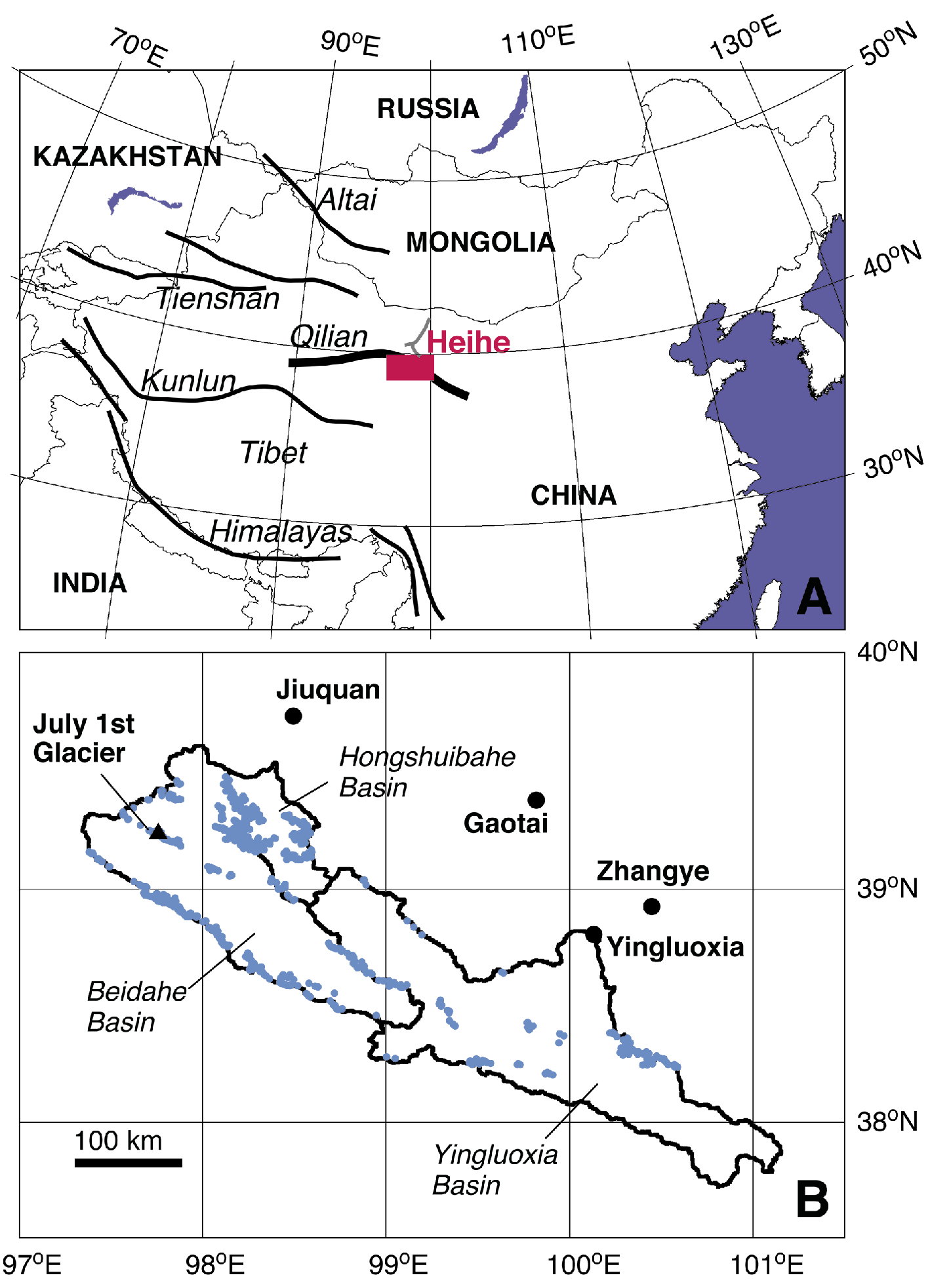
Figure 1: A) Location of the Heihe River, northwest China. Red rectangle indicates the area shown in panel B. B) The catchments of upper stream basins. Stations where several decades worth of hydrological and meteorological data are available are indicated (black circles), as is the July 1st Glacier, where glaciological observations were conducted for the period 2002-2005. Blue dots denote glaciers in the basin delineated from satellite images. Each grid square is equivalent to the grid of the used APHRODITE precipitation dataset (0.5°; Yatagai et al. 2009). |
As glaciers continue to retreat due to the on-going effects of global climate change, the availability of water during summer within river systems is expected to decline (e.g. IPCC 2007). Consequently, there has been considerable interest in gaining a better understanding of the contribution of glacial meltwater to river runoff in a number of catchments (e.g. Immerzeel et al. 2010; Kaser et al. 2010; Huss 2011). A mutual conclusion in these studies is that fluctuation of glacier meltwater significantly affects the river runoff if the river flows into arid terrain because water supply from precipitation will for a large part not attain the lower reaches. These studies tend to focus on evaluating the present-day contribution of meltwater to river runoff, and projections of likely future levels. In contrast, there has been less interest in the reconstruction of long-term historical runoff patterns at high temporal resolutions (e.g. annual) in glaciated catchments. One explanation for this may be that while paleoclimatic studies use several established proxies to reconstruct climate indices such as temperature, precipitation, or flood and drought events, finding an appropriate proxy for river runoff remains challenging. In this paper, we use models and climate reconstruction data to estimate the long-term (past 2000 years) runoff of the Heihe River in an arid basin in northwestern China (Fig. 1), where precipitation in the surrounding mountain ranges plays a significant role in providing water for the desert and oasis cities.
Reconstructing glacial runoff
 |
|
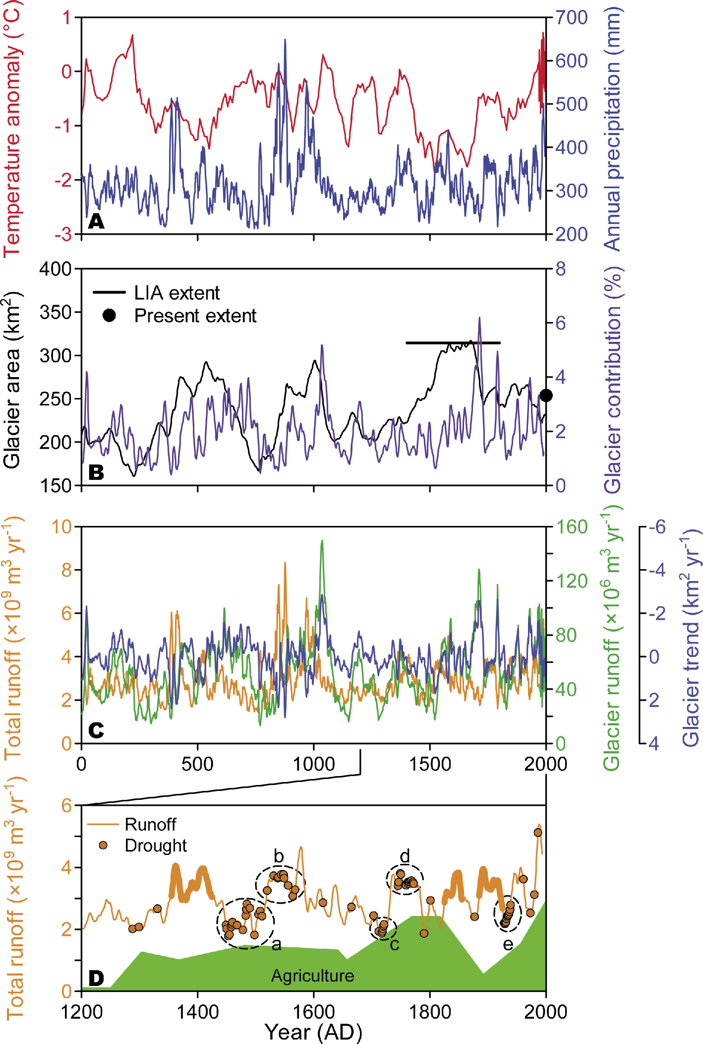
Figure 2: Climate and runoff records for the Heihe Basin covering the past two millennia. A) Annual mean temperature anomaly rel. to AD 1966-1995 (Yang et al. 2002), and annual precipitation (Zhang et al. 2003). B) Glacier area and contribution of glacier runoff to total runoff (Sakai et al. 2012). The present and LIA extents are shown by the black dot and line, respectively. C) Total annual catchment runoff, annual glacier runoff (Sakai et al. 2012), and trend of glacier extent (see equation in the main text). D) Five-year moving average of river runoff and drought events recorded in historical documents. Five prolonged drought periods (a-e) are highlighted (Sakai et al. 2012). Thick lines denote drought-free periods, which are discussed in the main text. Green shading denotes trends of agricultural activity in the region as retrieved from historical documents (Inoue et al. 2007; Nakawo 2011). |
We calculated river runoff components using an energy-mass balance model for glacier runoff (Fujita and Ageta 2000; Fujita et al. 2007) and a simple hydrological model for runoff from glacier-free terrain (Sakai et al. 2010). As meteorological variable input for the models, we used temperature and precipitation, and estimated relative humidity and solar radiation from precipitation (Matsuda et al. 2006; Sakai et al. 2010). Temperature and precipitation input data for the past 2000 years were obtained from tree-ring and ice-core studies (Yang et al. 2002; Zhang et al. 2003; Fig. 2A). Statistical downscaling was performed using meteorological data from neighboring stations (Fig. 1B). The spatial distribution and lapse rate were established by reference to gridded datasets (Kalnay et al. 1996; Yatagai et al. 2009) and are assumed to have remained constant through time. Accuracies of the models were tested against observed hydrological and glaciological data in the same region (Sakai et al. 2009, 2010). Changes in the size of the glacier are significant over the long term, as water runoff is significantly affected by changes in the extent of the ice cover. A simple but plausible glacier fluctuation model was established using an area-volume relationship for the glacier (Chen and Ohmura 1990; Liu et al. 2003). Glaciers in the catchment were delineated from a Landsat ETM+ image (Fig. 1B), and were classified into five classes based on the area they cover, as changes in glacier size vary according to their geometry (van de Wal and Wild 2001; Raper and Braithwaite 2006).
Controls on glacial runoff
We validated our calculated results against the known extent of glaciation in the Little Ice Age (LIA), which was determined from the positions of moraines on the satellite image and the present extent (Fig. 2B). River runoff levels reconstructed throughout the last 2000 years correlate closely with precipitation (r = 0.997, p<0.001; Fig. 2A and 2C), due to the small proportion of the catchment that was glaciated (1.3±0.2%). The average contribution from glacier runoff (1.8%) is slightly larger than might be expected based on the proportion of the glaciated catchment (1.3%), due to the effect of altitude on precipitation (it increases with altitude), which allows the glaciers to provide relatively more water than their extent would indicate.
We defined the trend of glacier extent (GT, km2 yr-1) by the following equation,
GT(t)=(GA(t+1)−GA(t−1))/2,
where GA and t denote glacier extent and time, respectively. Glacier runoff, and its contribution to the total river runoff, both showed a strong negative correlation with the trend of glacier extent (r = –0.741 and r = –0.925 respectively, both p<0.001, Fig. 2C). This implies that the glaciers have supplied excess meltwater to the river by reducing their ice storage during periods of glacier shrinkage. In contrast, when the glaciers were expanding during colder or more humid periods, storage of ice mass in the body of the glacier increased, and glacier runoff and its relative contribution to total runoff decreased accordingly. These results suggest that variations in glacier runoff and its contribution to river runoff do not always relate directly to glacier extent, but are also influenced by the nature of glacier response to changing environmental conditions.
Impact of human activities
Many historical documents covering the last 800 years are available for the Heihe River catchment, and allow us to compare our reconstructed river runoff levels with contemporary accounts (Fig. 2D). We use a record of drought events and highlight five of the most significant drought periods, which continued intermittently for periods of several years (labeled a-e), and a record of relative agricultural activity in the middle reach of the river (Inoue et al. 2007; Nakawo 2011). River runoff levels during drought events a, c, and e were relatively small; consequently, we suggest that these droughts were climate driven. In contrast, reconstructed river runoff during drought events b and d were relatively large. Therefore, these drought events may be attributable to human activity rather than climatic factors, and might have been caused for example, by excessive extraction of river water for irrigation. Indeed, in this region, the pioneering phase of agricultural land-use had already begun in the 13th century. In figure 2D, three relatively long drought-free periods are marked with thick lines. During the first period (AD 1355-1425), agricultural land-use had declined; therefore, human-induced droughts were unlikely, as there was a plentiful supply of natural water available (high runoff) to meet demand. The latter two periods (AD 1825-1855 and AD 1885-1925) coincide with the Dongan Revolt, during which agricultural land was left uncultivated.
Our results suggest that longer drought-free periods in the Heihe River catchment only occurred during phases with relatively low human impact and high river runoff (Sakai et al. 2012).
Past or future?
In the studied catchment, glacier extent is too small for glacier runoff to significantly affect the total runoff of Heihe River. Fluctuations in river runoff are primarily controlled by precipitation. Consequently, patterns of past precipitation levels reconstructed from ice cores and tree rings can be used to reconstruct changes of water availability in this region. However, in a more glaciated catchment, river runoff can fluctuate in a more complicated way and the influence of the glaciers is more important. It is generally believed that glacier shrinkage will lead to a shortage of water resources under a warming climate; however, our study suggests that the trend of glacier extent, advancing or retreating, is, on a shorter term, a more significant control on glacier runoff and its contribution to the river system.
Forecasting changes to the extent of glaciers, and the impact on river runoff is a societal need under the present warming climate. Current river-runoff level projections contain numerous uncertainties caused by changing environmental conditions and the application of differing general circulation and regional models. We have shown that our river runoff reconstruction based on paleoclimatological data combined with historical documents from the region, can be used to discriminate the runoff types and attribute the nature of drought events in the arid Heihe River Basin.
Selected references
Full reference list online under: http://pastglobalchanges.org/products/newsletters/ref2012_2.pdf
Fujita K, Ohta T, Ageta Y (2007) Hydrological Processes 21(21): 2882-2891
Immerzeel WW, van Beek LPH, Bierkens MFP (2010) Science 328: 1382-1385
Sakai A, Fujita K, Nakawo M, Yao TD (2009) Hydrological Processes 23(4): 585-596
Sakai A et al. (2010) Hydrological Processes 24(19): 2798-2806